Yesterday we had a high of 48° and a morning low of 35°. We ended up with 1.01 inches of rain from the system which passed by bringing our monthly total to 3.37 and 5.50 inches for the season so far.
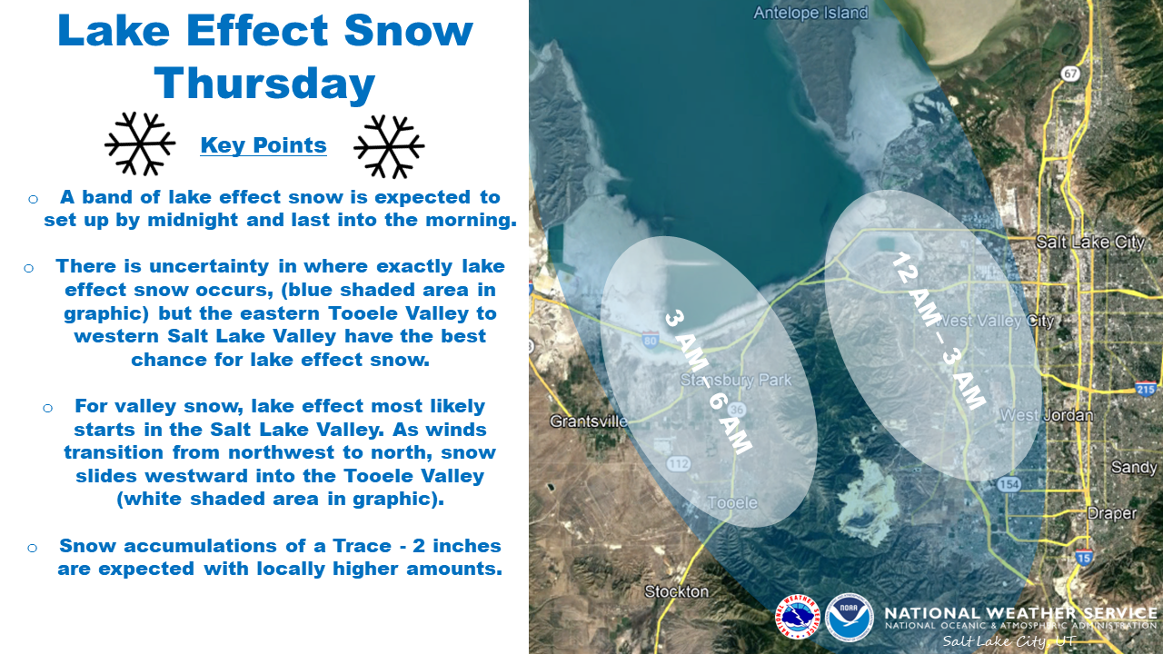
Here is an interesting tidbit – the Great Lakes aren’t the only area that receive lake effect snow. The Great Salt lake in northeastern Utah has lake effect snow advisories for today:
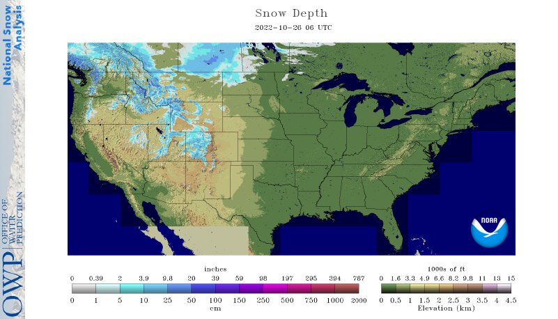
As of yesterday, we have 8.4% of the U.S. with snow coverage
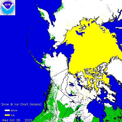
This is the current snow cover map for Alaska, Western Canada, Eastern Russia, and the Arctic:
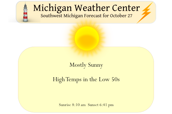
No snow for us (yet). Skies will be mostly sunny today with an increase in some high clouds this afternoon. Highs will top out in the low to middle 50s which is near normal. Light winds are expected today. Dry weather will continue Friday, Saturday, and into Sunday morning. The next chance for rain comes Sunday afternoon.
Forecast Discussion
The forecast question is the potential for patchy fog/mist. The
latest nighttime microphysics satellite image has low clouds
remaining across eastern lower Michigan. Along the US 127 corridor
eastward. There are some mid to high clouds moving along the I 94
corridor where low clouds have dissipated. Winds have calmed and
temp dewpoint depressions are 2 to 5 degrees. So as the
temperatures drop there remains a chance that patchy fog forms.
Have patchy fog around sunrise and then dissipating by mid
morning. It shouldn`t be dense and focused in the low lying
regions.

The upper level pattern has a deep upper level trough located
over the four corners of the United States with high pressure
through the mid and low levels over the Midwest. Given that, dry
and stable air will dominate the pattern which will continue
through the day on Friday.

.LONG TERM...(Friday night through Wednesday)
Issued at 336 AM EDT Thu Oct 27 2022

-- Dry weather continues Friday night into Sunday --

The dry weather in the short term will continue into the long term
period which begins Friday night. Sprawling high pressure will
dominate the Great Lakes weather scene into Saturday night at which
time the high will begin to slide off to the east. Focus will then
shift to a cut off low in the southern stream that will move our
direction. Friday night through Sunday though will feature mainly
clear skies and near normal temperatures.

-- Chances for rain Sunday afternoon through Monday evening --

Chances for rain begin Sunday afternoon...continuing Sunday night
and Monday before ending Monday evening. The system responsible for
the rain is a cut off low that develops over the Southern Plains in
the next couple of days. At present the system is a strong shortwave
diving southward through the Central Rockies (centered over Utah).
The upper low is picked up by the northern stream this weekend,
moving to Arkansas on Saturday and Indiana by Sunday. The wave
deamplifies and weakens as it moves in Sunday into Monday, but it
will still be worthy of 30-60 pct chances for rain (highest south)
Sunday night. Precipitation amounts look to be on the light side
overall, ranging from around a tenth of an inch across the northwest
CWA towards Ludington to a quarter of an inch in the south at
Jackson. The precipitation should end Monday evening as what is left
of the system washes out/moves east.

-- Dry weather returns for Monday overnight through mid next week --

Dry weather returns for the remainder of the 7 day forecast for
Tuesday through Wednesday night. The operational Canadian, ECMWF and
GFS all show a deepening longwave trough in the Western U.S. during
this time frame with ridging building downstream over the Central
and Eastern U.S. Rising heights and southwest flow should bring dry
conditions and at the very least near normal temperatures to our
area during this time frame.
More freezing temps are on the way! Wow, just wow!
The below normal temp days keep rocking! Incredible!
Such a beautiful below average day out on my hood grilling some steaks and drinking some sprites in my Michigan hoodiee tonight.. Its been a perfect cool Fall! 😎 INDY
Still barely any snow in the Lower 48. We continue to be well behind last year.
The beginning of November looks to be the nicest stretch of weather I can remember for that time of year in Michigan. Sunny and 65-70 degrees.
Not sure how sunny it was but early November 2020, 2016 and 2015 all started out very warm with many days in the 70’s and 60’s. So there is kind of a trend for there to be a warm period in the first half of November and this year seems like it will continue that trend. In 2020 there were 6 days of 70 or better reaching 77 on the 9th. In 2016 there were 4 days in the 70″s and 6 days of 65 and above.
Slim
November 2020 started out cold with measurable snow!
November 2016 was fairly warm but cloudy and rainy.
Way different this year.
Bill Steffen is in London, England. So far, he has not made a comment on the weather there. But I just looked, and London is having very warm “Old Wives Summer” or “St. Martin’s Summer” like weather and record or near record warm temperatures are expected for the next several days. With highs today thru at least Sunday in the upper 60’s to 70 and lows in the upper 50’s.
Slim
Wow sounds like a great time to visit
Yesterday was one of those days when the high for the date was just after midnight. So while the official H/L for the day was 60/33 that high of 60 was reached at 1:23AM. Most of the daylight hours were in the 40’s. There was 0.86” of total rain fall yesterday most of that fell before 7AM and there was no sunshine. The overnight low both here and at GRR was 29 that will be the new low for this month so far. Here in MBY I recorded 0.09” of rain fall after 7AM yesterday. At the current time there… Read more »
We have definitely lost quite a bit of leaves on the trees as of late. Obviously the trees hanging on to the most at this point are the oaks which is expected. The maple tree in my yard that was in peak color about 12 days ago is mostly bare at this point
Yes, more and more trees are now bare. This year most of the area had good color and it lasted for some time. The oaks while still having still having many leaves have now turned to dark red to winter like brown.
Slim
It’s a cold 28 this morning out here in the countryside at my house. Coldest morning so far this season.