
We had .65 of an inch of rain overnight from storms. It is a warm and muggy 74° at 6 am this morning, the dew point is 73.5°. Our total rainfall for the month is 1.43 inches and 14.22 inches for the Met summer (Otsego totals).
This should be the last day of tropical air as a more humane airmass moves over the state tomorrow through the weekend. It will be cloudy through mid-morning, then gradual clearing, with a high near 87. There will be a light west wind becoming southwest 6 to 11 mph in the morning.
Forecast Discussion
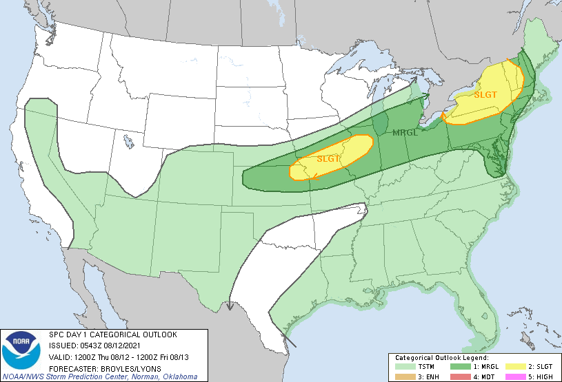
- One more round of showers and storms tonight

Latest batch of storms continues to drop heavy rain across the
Lansing area. Flood advisory currently in effect and we will
upgrade to a warning given continued rain over the next hour
exacerbating flooding of roads and highways.

Storms will continue to affect the southeast forecast area into
this morning although the severe weather threat is minimal given
the airmass has been worked over by previous rounds of convection.

Expect a break in the action for all but the far south of Lower
Michigan this afternoon then one more round of storms is expected
along the cold front tonight. Some bowing line segments and taller
updrafts should bring isolated, marginal threat for severe and
ending Friday morning.

- Finally drying out for the weekend

Dew points fall from the 70s to the 50s and lovely summer weather
is in store for the weekend. Return flow beings next week with
increasing chances for showers and thunderstorms by Wednesday.
Recurving tropical cyclone or its remnants should stay east of the
Great Lakes.
Weather History for SW Michigan
August 8
1894: Only four days after record cool weather in the 30s and 40s, the thermometer soars to record highs of 96 at Grand Rapids and 99 at Lansing.
1939: A tornado outbreak across central and southern Lower Michigan resulted in two deaths and about 100 injuries. A violent tornado moved across the southeast part of Kalamazoo, destroying dozens of homes and killing two people. More homes were destroyed and six people were injured in northern Kent County, northeast of Cedar Springs.
1973: A tornado injures five people and damages eight houses in Carson City, Montcalm County.
1977: A tornado destroys a barn and trailer north of Marion in Osceola County.
August 9
1964: Less than a week after hitting 100 degrees the temperature plummets to a record cold 38 degrees at Lansing and 43 at Grand Rapids. Muskegon went from 99 degrees on the 3rd to a low of 40 degrees this morning.
1994: Cool weather prevails for several days with low humidity and high temperatures only in the 60s. Record cool maximum temperatures are observed at Grand Rapids and Lansing, where the high on this date is only 64 degrees.
2009: A thunderstorm brings damaging downburst winds estimated at 70 to 75 mph to Muskegon County. The storm strikes Hoffmaster State Park and Fruitport, downing dozens of trees and causing some damage to homes. The storms continue into Kent County, hitting Kent City and Sparta. Another severe thunderstorm produces a downburst that blows part of the roof off a school in Jackson.
August 10
1944: The first half of August produces seven days in the 90s, peaking with a record high of 98 degrees at Grand Rapids and 95 at Muskegon on this date.
1971: A tornado damages some cottages near Croton Dam in Newaygo County.
1972: High pressure from Canada brings record low temperatures, including 40 degrees at Lansing, 45 at Grand Rapids, and 47 at Muskegon.
August 11
1864: Lansing hits 101 degrees. This was the all-time high-temperature record for Lansing before being broken by a reading of 102 in 1894.
1941: It was a soggy day as Grand Rapids and Muskegon set daily rainfall records of about an inch and a half.
2004: Cool and cloudy weather was observed with high temperatures only in the 60s. Record low maximum temperatures occur at Grand Rapids with 63 degrees, 64 at Lansing and 61 at Muskegon.
August 12
1864: The temperature hits 96 degrees at Lansing for a record high. The record for the coolest high temperature is set exactly one hundred years later in 1964 when the high is only 62 degrees at Lansing
1979: A summer cool spell sets several record lows over the course of a week. On this date, Muskegon falls to 45 degrees for a record low.
2016: Record rains fall at Grand Rapids with 2.61 inches for the day. A small tornado destroys an outbuilding and takes down a few trees east of Douglas, Michigan.
August 13
2002: Severe weather produces widespread wind damage across southwest Lower Michigan. A tornado struck near Rockford in Kent County, causing minor damage to several homes and vehicles.
August 14
1987: A total of 3.61 inches of rain falls at Grand Rapids, making this the second wettest August day on record and contributing to a record monthly total of 8.46 inches.
1988: A tornado struck East Lansing and then proceeded southeast, leaving an intermittent damage path south of Okemos to Gregory. A man camping near Stockbridge was killed when a tree fell on him.
1995: Lightning struck and killed a 33-year old man walking through his campsite in Coldbrook Park in Kalamazoo County.
Weather History for SE Michigan
August 8
On August 8, 2001, temperatures soared into the upper 90s. This was the fifth day of a six-day heatwave with temperatures in the 90s. Highs reached 99 degrees in Detroit and Saginaw, and 98 in Flint, all of which are records for the date.
Also on August 8, 1984, three tornadoes were reported around Genesee county at 2:08 pm, 2:15 pm and 2:20 pm. The tornados ranged from F1 through F3 and caused between $25,000 and $2,500,000 in damages.
August 9
On August 9, 2009, numerous roads were flooded and closed. The most significant road damage was M 53 south of Imlay City which was washed out and had to be closed for about 10 days. Over two dozen homes were also damaged due to the flooding. A local state of emergency was declared. Five to eight inches of rain falling within a 30 hour period lead to widespread flooding across southern Lapeer county. A few reported rainfall totals include 7.4 inches in Almont, 6.3 inches in Imlay City, and 5.65 inches in Lapeer.
Also on August 9, 2001, a heatwave from the 5th through the 9th, resulted in temperatures pushing well up into the 90s. On the 6th, the excessive heat caused at least 200 people to seek medical attention. The peak of the heat wave came on the 8th when temperatures reached a record high of 99 degrees.
August 10
On August 10, 2012, a strong moisture-laden storm system brought widespread moderate to heavy rain to Southeast Michigan. Saginaw received 6.93″, the most of any other location by far and its highest one-day total on record. Combined with 1.10″ from the previous day and another 0.26″ from the following day, the three-day total from August 9-11 of 8.29″ ironically catapulted Saginaw to one of its wettest summers on record despite being amidst an ongoing severe drought.
Also on August 10, 1964, Detroit reported a record amount of precipitation in a day. The total precipitation was 3.21 inches.
August 11
On August 11, 2014, widespread heavy rain and severe flooding were observed across Southeast Michigan as a moisture-laden and unseasonably strong low-pressure system traversed the area. Rainfall generally ranged from 2 to 5 inches across Southeast Michigan. The heaviest rain, a band of 3 to 6 inches, fell in the heavily urbanized corridor of Wayne, Oakland, and Macomb Counties, centered on the I-696 corridor, especially near and east of I-75.
The resultant flooding was severe due to excessive runoff. Up to 14 feet of water was reported at the I-696/I-75 interchange and nearly all major expressways in the area were shut down due to flooding and debris. Dozens, if not hundreds, of cars, were submerged or suffered flood damage and numerous homes in the Detroit area were flooded.
There were no direct fatalities associated with the flooding, although two indirect fatalities were reported. The first was a 100-year-old Warren woman who was found deceased in her flooded basement. The second was a 68-year-old Warren man who suffered a heart attack while attempting to push his vehicle out of flooded waters in Oak Park. Cleanup efforts lasted well into the following week. The total damage came to an incredible $1.8 billion.
Also on August 11, 1967, three record lows of 47, 46 and 47 degrees occurred in Detroit from the 11th-13th, respectively.
August 12
On August 12, 1988, Saginaw county was belted with a peak wind gust at 81 mph at 5:49 pm.
August 13
On August 13, 1975, a 60 mph wind gust accompanied a severe thunderstorm just after dawn at 6:45 am in Genesee county. Also, in 1947, the temperatures reached 94 degrees on the 12th and 96 degrees on the 13th in Flint.
August 14
On August 14, 1964, the overnight temperature dropped to 41 degrees in Flint, which is the record low temperature for the day. Curiously enough, the very next year, in 1965, the daytime temperature rose to 97 degrees, setting the record high temperature for this day!
Heavy rain will bring localized flooding this morning. There will
be flooded roads in the Lansing area.

There is a marginal risk of severe weather for this evening and
overnight as storms form along a cold front moving southeast
through Lower Michigan. The main threat will be for isolated
damaging winds.
I hope that all of storm lovers are happy!
Not trying to be political…but really how do we move to all electric when it is so unreliable? And every you go the hum of generators….praying for electric to come back on!!!!
They have added more days to our power being brought online.
*Off soapbox*
*everywhere
I hope you get it back on sooner than later. No time is the right time to be without it. It’s either too hot or too cold out or you just bought a bunch of freezer stuff. Seven or 8 years ago we had a nasty Fall storm that went thru. The weather had been hot and turned very cold after the storm. We went a week without power. Not fun. We had our grill for cooking outside. I learned to like hot tea made with hot water from the faucet and wore layered clothes and a jacket in the… Read more »
Rock on SS! I vote for all solar and wind power!
We are on about 28 hours without power. Saw a bunch of BBC power trucks pull in to town… Cross fingers soon for us. This stinks.
☹️🙏🤞
.93 in of rain here overnight. Loved the light show last night. We had a tree fall on our house on Tuesday from that storm. A good day for the clean up crews today before the next round.
That is awful! I hope there isn’t alot of damage.
So yeah, this is what it’s like over in this area. New GMC smashed. Check out the pics:
https://www.wlns.com/news/michigan/photos-michigan-wakes-up-to-flooding-damage-and-no-power/
Wow! Looks like a war zone!
Power came back on this morning after being out about 16 hours. Luckily we have a generator to run the vital things like the AC and the WI-FI. Wild light show last night! Went on for hours. Now we just need to get rid of this crazy humidity. Day 6 with dew points into the 70’s.
Our final round of weather was all rain overnight. Rain gauge is holding 1.5 inches this morning.
Local radio station just said 800,000 customers without power in Michigan. Lightning strike last nite zapped my computer, wireless device and furnace/air electronics. Amazingly I still have power.
Lots of light, thunder and rain here! The 2:30am storm was constant lightning and slow roll thunder.
A rather warm morning once again. The overnight low here was 70 even with the rain. The storm last night had the most lightning and thunder here in more than 2 years. As far as rain fall here at my house there was a total of 0.64″ in two events one during the afternoon and one around 8:30 last night. At this time it is cloudy and 72 with a DP of 72. The mean temperature at Grand Rapids now has a departure of 0. And at the airport there has been a reported 2.25″ of rain fall. I would… Read more »
2.1 inches in my gauge in Hamilton.
Wow, what a storm! It stormed all night. Local news this morning said rainfall reports from around the greater Lansing area range from 2.5 to 4”, nearly tripling the daily rainfall record. Multiple road and even two freeway closures due to flooding. We lost briefly lost power for only the second time in the five years since we bought this house. Our power lines are underground so it just never happens. I see the Detroit area is under flash flood warnings once again. They’ve had a rough summer.
There was a lot of lightning off to the south and east of me all night. The storm last night was one of the few time in the last couple of years that there was some loud thunder here at my house.
Slim