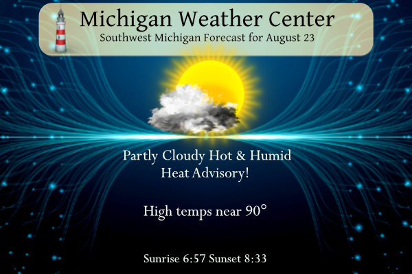
It will not be a nice day outside unless you like tropical air. Temperatures will be in the low 90s with heat indexes from 103 to 107°. I will do my chores this morning and then spend the rest of the day indoors keeping cool. Many schools will be closed today or have half-days due to heat advisories in place.
Heat Advisory
…HEAT ADVISORY NOW IN EFFECT FROM 8 AM THIS MORNING TO 2 AM EDT
FRIDAY…
* WHAT…Heat index values up to 107 are expected.
* WHERE…Van Buren, Kalamazoo, and Calhoun counties.
…HEAT ADVISORY NOW IN EFFECT FROM NOON TODAY TO 8 AM EDT
THURSDAY…
* WHAT…Heat index values up to 104 are expected.
* WHERE…Ottawa, Kent, Allegan, and Barry counties.
* WHEN…From noon today to 8 AM EDT Thursday.
* IMPACTS…Hot temperatures and high humidity may cause heat
illnesses to occur.
* WHEN…From 8 AM this morning to 2 AM EDT Friday.
* IMPACTS…Hot temperatures and high humidity may cause heat
illnesses to occur.
PRECAUTIONARY/PREPAREDNESS ACTIONS…
Drink plenty of fluids, stay in an air-conditioned room, stay out
of the sun, and check up on relatives and neighbors. Young
children and pets should never be left unattended in vehicles
under any circumstances.
Take extra precautions if you work or spend time outside. When
possible reschedule strenuous activities to early morning or
evening. Know the signs and symptoms of heat exhaustion and heat
stroke. Wear lightweight and loose-fitting clothing when
possible. The Occupational
Safety and Health Administration recommends scheduling frequent
rest breaks in shaded or air-conditioned environments to reduce risk during outdoor work.
Grand Rapids Forecast
8 23 grrKalamazoo Forecast
8 23 kzoSPC Outlooks
SW Michigan Weather History
August 20
1992: Temperatures fall into the 30s in some rural areas during the coldest August on record at Grand Rapids. Record lows for the day include 42 degrees at Muskegon and 43 degrees at Grand Rapids.
2007: Heavy rain falls across southern Lower Michigan for the second consecutive day. Grand Rapids and Lansing both set daily rainfall records and some places see over 4 inches of rain for the two-day total on the 19th and 20th.
2016: Tornadoes strike from Bangor to Grand Rapids and east of Belding. There were no injuries, despite damage to several buildings and hundreds of trees being downed.
August 21
1958: Heavy rains fall for the second day in a row, causing some flooding in the Grand Rapids area where the two-day rain total from August 20-21 was over 4 inches.
1975: A tornado blew down fruit trees in an orchard at Climax, in Kalamazoo County.
2003: A tornado with top winds around 120 mph strikes eastern Ingham County injuring two people and destroying two homes. The damage path was 4 and a half miles long and up to one-half mile wide.
August 22
1936: The Dust Bowl summer of 1936 produced more record heat, with a high of 98 degrees at Grand Rapids and 94 at Lansing.
1964: Tornadoes struck in Calhoun, Lenawee, and Hillsdale Counties. Three people were injured northeast of Battle Creek as a house and factory were damaged.
1966: A tornado struck Bellevue in Eaton County, damaging a house, garage, and two cars.
2001: Severe weather and flooding hit Allegan, Ottawa, and Kent Counties. Damaging winds hit Hudsonville, Plainwell, Dorr, and Grand Rapids. Flooding occurred in eastern Van Buren and Kalamazoo Counties where three to five inches of rain is estimated to have fallen in less than 6 hours. Several streets were closed by flooding in Oshtemo flooded. Some businesses had to pump water out of their stores in Kalamazoo during the height of the storms.
August 23
2002: Several inches of rain in less than three hours caused flash flooding in Kalamazoo, where two homes and two businesses sustained extensive damage. Waldo Stadium, on the campus of Western Michigan University, also had major flooding. At one point, three feet of standing water covered the entire football field. The flooding caused an estimated 200,000 dollars in damage.
2007: Severe weather strikes Lower Michigan with large hail and damaging winds. Some of the worst damage is across Montcalm County where thousands of trees are downed by a tornado and downburst combination that produced estimated wind speeds up to 100 mph.
August 24
1947: The second long heat wave of the month comes to a close with record highs of 98 degrees at Grand Rapids and 96 degrees at Muskegon, contributing to the warmest August on record across West Michigan.
2006: Up to baseball-sized hail fell from a severe storm at Grand Junction in Van Buren County.
2007: Tornadoes strike Lower Michigan, with the worst damage near Potterville in Eaton County. Five people were injured and 15 homes were destroyed by a tornado with peak winds estimated at 140 mph. A weaker tornado hit southeast of Lansing but the damage was limited to trees falling on mobile homes.
August 25
1910: A tornado injured four people near Scottville in Mason County. The tornado destroyed a cement block building, hurling the roof a half mile. Several other buildings were unroofed.
1940: A stalled cold front brings clouds and very cool high temperatures. At Muskegon, the high was only 56 degrees and Lansing was 57, both records for the coldest maximum temperatures for the month of August. The high of 60 degrees at Grand Rapids is only one degree higher than the record of 59 degrees set on August 26, 1987.
2004: A strong downburst tore the roof off a section of the Maple Valley High School in Eaton County. The same storm produced a weak tornado minutes later that took the tin roof off a house in Vermontville.
August 26
2000: Heavy rain and high winds produce scattered damage and some flooding. The roof of a bowling alley near Jackson was damaged by an apparent microburst. Roads were closed due to flooding across southern Kalamazoo County.
SE Michigan Weather History
August 20
On August 20, 2011, severe thunderstorms were concentrated mostly along the M-59 corridor, causing the Dream Cruise along Woodward Avenue to be cut short, as minor damage was reported. The other notable item from this event was a weak tornado reported near Chesaning in Saginaw County.
Also on August 20, 1996, 0.29 inches of rain fell in Detroit. This would account for over half of the 0.43 inches that would ultimately fall that month. August 1996 ended up being the driest August of the 20th century for Detroit.
August 21
On August 21, 2003, temperatures soared into the 90s as a cold front passed through southeast Michigan during the evening hours. Thunderstorms developed just after 6 PM EDT over Saginaw Bay and continued to develop to the southwest. This was a major severe event with hail up to the size of golf balls in Huron and Genesee Counties and wind damage from Monroe and Washtenaw Counties to Lapeer and Sanilac Counties. There was also one tornado that moved into far western Livingston County from Webberville in Ingham County.
Also on August 21, 1975, an F0 tornado developed from a severe thunderstorm passing through Wayne County causing $3,000 in damages.
August 22
On August 22, 1964, an F3 tornado hit Lenawee County at 2:35 PM around the community of Springville. Two people were injured as a result of this tornado. This was the last F3 or greater tornado to hit Lenawee.
August 23
On August 23, 2007, the event began with a thunderstorm in Midland County that moved east across the Thumb. This storm produced some large hail and the first tornado of 2007 near Argyle in northwestern Sanilac County. At the same time this was occurring, a very fast-moving squall line approached the lower half of Southeast Lower Michigan. Although the squall line became less organized, it still produced numerous reports of wind damage between M-59 and Interstate 94.
Also on August 23, 1998, Clio reported 1-inch hail that came with a severe thunderstorm at 6:50 pm.
August 24
On August 24, 2011, scattered severe thunderstorms developed over Metro Detroit, with both large hail and wind damage occurring. There were over 20 reports of severe weather including golf ball-sized hail in Marysville.
On August 24, 2007, a tornado and severe weather outbreak hit the greater Flint and Detroit metro areas. The strongest tornado was an EF2 that was on the ground for 26 miles from northern Livingston County, through Fenton, and into Holly. Additional tornadoes hit northeast of Durand (EF0), near Hadley (EF1), and near Salem (EF0).
Also on August 24, 1947, the temperature soared to 101 degrees in Flint, which is the record high temperature for the month of August in the city of Flint.
August 25
On August 25, 1948, a record high of 98 degrees occurred in Detroit. Also, records of 95 degrees on the 24th and 98 degrees on the 27th were reached during this short hot spell.
August 26
On August 26, 1970, 1-inch hail was reported at 5:15 pm from severe thunderstorms passing through Saginaw County. Also, in 1986, thunderstorms produced wind gusts of 64 mph in Genesee County.
Forecast Discussion
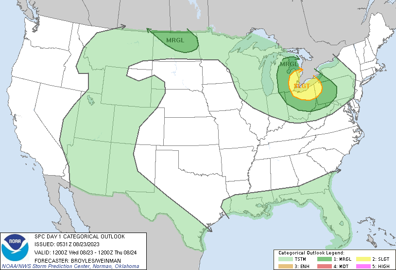
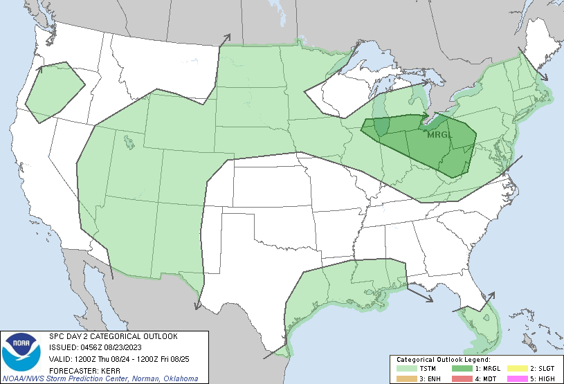
.SHORT TERM...(Today through Thursday)

-- Possibly severe storms this morning with heavy rain --

Upper level moisture and instability will bring convection to the
lower peninsula this morning. The biggest severe weather threat
this morning will be from hail, locally heavy downpours and a chance
of damaging winds.

The biggest question this morning is where the upper level forcing
will form and move the shear based convection. Beginning with the
850mb meso-analyst we see the strong LLJ from the west and a strong
warm front over Wisconsin with a strong area of Surface Based CAPE
and moisture over the upper MID WEST. However that strong warm
frontal boundary and the strong high pressure is keeping that CAPE
West of Michigan. Lower Michigan, with temperatures in the low 70s
to upper 60s remains in the cold pool with a very strong inversion
present from the surface to around 5Kft. The LCL is around 850 mb
with CAPE above that around 3000 J/kg. lapse rates from 850mb to
500mb according the model soundings are 7.1 C/km. So this a very
good environment for storm development aloft. There is also highly
anomalous moisture advecting into the region to the magnitude of 1.5
to 2 inches of PWATS.   Another concern is the presence of 900 to
1100 J/kg of DCAPE over SW Michigan. If the storms can mix down then
damaging winds could be a concern. The main question there remains
if the inversion is strong enough. So hail remains the main threat.
The area remains in a marginal risk for excessive rainfall and this
is due to the copious amounts of moisture aloft and the PWATS I
mentioned above. If you couple this with the strong moisture
transport vectors from the west and there is a chance for locally
heavy rainfall, especially in training thunderstorms.

 The CAMS are very diverse in their opinion and have varying
solutions. The latest MRMS radar at 0629Z shows reflectivity
streaming across Eastern Lake Superior, the Eastern U.P. and across
Lake Huron. This reflectivity best fits the HRW ARW member of the
HREF. The HRRR is also similar but slightly stronger. As these
project this morning the HRRR is the more robust solution forming
scattered convection as it spreads to the southeast across lower
Michigan. The ARW keeps convection primarily over the eastern to
central half of the lower Peninsula.   SPC has put the eastern
portion of lower MI in a slight risk for severe storms with areas
west of US 131 in a marginal risk for severe storms.  The best
chance for storms will be this morning from after 4 AM until noon.

-- Heat advisory today with possible afternoon storms --

The convection that moves through this morning will clear through
with a shift of the warm front and the high pressure this afternoon.
The clouds should clear out quickly and given the warm air advection
expect the area to heat up quickly this afternoon and evening. Given
any moisture at the surface, any hot temperatures will couple with
this moisture to create a stifling heat which will continue into the
evening. The heat advisory will continue for much of the forecast
area today. With the heat and significant incoming shortwave
radiation comes elevated ozone production. Please refer to the
Department of Environment, Great Lakes, and Energy website for
further details.

That heat and moisture could allow for late afternoon to early
evening thunderstorms and showers. Have increased POPS but then
remain in the 20 to 30 range. The question remains if there will be
enough instability for storms. The best location will be along the
US 127 corridor and especially southeast of I 69.  If the storms do
form there is the potential given the CAPE and LLJ present that they
could become severe.

-- Heat advisory with storms possible on Thursday --

The presence of an upper level wave, warm air advection and moisture
will allow another chance for storms tomorrow. Along with that is
the continued signal of +28c temperatures at 850mb. That should
correlate to be the highs in the mid 90s and apparent temperatures
in the 100 to 105 range. So have expanded the heat advisory for the
I 94 corridor through Thursday.

.LONG TERM...(Thursday night through Tuesday)

-- Zonal upper flow to bring a few chances of precipitation --

A general northwest flow will be in place in the long term between a
retrograding upper high that moves from the Mid Mississippi Valley
and Southern Plains into the Southwest U.S. and Rockies between
Thursday night and early next week and an upper low north of Hudson
Bay. There are several chances for precipitation... 1) associated
with the surface front sliding south Thursday night, 2) another
front dropping south Friday night and Saturday and 3) a deeper upper
trough and a surface front Monday night through Tuesday night.

As for the first chance of precipitation in the long term, not
difficult to envision showers and storms ongoing during the evening
along and ahead of a cold front. There should be convection ongoing
with the ECMWF more bullish on surface based CAPE and therefore
precipitation. It looks like conditions dry out overnight as the
front goes south. Mainly dry weather is then expected on Friday.

Our next chance for precipitation will come Friday night into
Saturday as another front drops in from the northwest. Aloft, a
shortwave will be moving through the Northern Great Lakes from Lake
Superior southeast into Ontario. At the surface the associated
front, more of a weak trough slides through our area. This does not
look like the greatest chance of precipitation, but we do have 30-40
pops in the forecast across Central Lower Michigan Friday evening.

Our final chance for precipitation in the long term will come Monday
night through Tuesday night as a deeper trough moves into the Great
Lakes, sharpening overhead. Our pops in the forecast are a bit
lackluster (20 pct) based on model blends, but see this increasing
with time given the look of the upper pattern. Given some of the
moisture being pushed south by prior fronts, understand the lower
pops, but diurnally driven showers and storms look likely. The ECMWF
is more bullish with this event too and feel its the model to follow
here.

-- Temperatures overall a bit cooler than normal in the long term --

The northwest upper flow will ensure that we have cooler weather
with the upper trough nearby and at times overhead. At 850mb we have
temperatures in the lower teens from Saturday through next
Wednesday. Those numbers for mid to late August are on the cool
side. What it will do will provide very comfortable high
temperatures each day in the 70s. Lows at times will be dipping into
the 40s across Central Lower Michigan through the period.
Rain? What rain? A total 100% miss for the GGR area! One of the worst forecasts ever! Hyping the heavy rain chances for days and zippo! Wow just wow!
This is too hot. Our temp difference from fam in southern Florida is 3 degrees, but our feels like is 3 degrees hotter!!
5PM update at Grand Rapids air temperature 90 Dew Point 79 Heat Index 106. Lansing 91 Dew Point 76 Heat Index 106. Here in my yard the temperature is now up to 95 the DP is now down to 81 with a heat index of 118. Houghton Lake air temperature 65 Dew Point 62.
Slim
30 degree difference across lower Michigan. That’s impressive.
It’s Summer…warm is just right. Not to mention, nightly forecasting of storms for us that never occur.
Keep waiting for a good nighttime thunder storm. I have been waiting all summer and there were none to speak of last year either.
Slim
Rain, what rain?
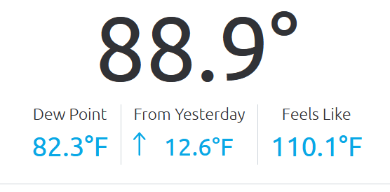
The official temperature at GRR at 4PM was 89 with a DP of 79 for a heat index of 104. Here in MBY I now have a temperature of 94 with a dew point of 82 for a heat index of 118° At Benton Harbor their temperature is 93 with a dew point of 81 for a heat index of 114. This is one of the highest dew points I can remember. I took a walk around the house just to get a feel of it.
Slim
BTW not too far to the north of here temperatures are in the mid 60’s over much of norther lower Michigan and in the low to mid 60’s in the UP up there they are saying what heat are you talking about.
Slim
At work in mount pleasant it was 75 at 4:30. I drove home 25 miles SW of mount pleasant it is is 88. Crazy.
North and east of there it is even cooler.
Slim
Action Day is in effect for the following Michigan counties…
Allegan, Kent, Muskegon, Ottawa, and Van Buren
People and businesses are urged to avoid activities which lead
to ozone formation. These activities include refueling vehicles
or topping off when refueling, using gasoline powered lawn
equipment, and using charcoal lighter fluid. Positive activities
include car pooling, biking to work, delaying or combining
errands, and using water based paints.
It is recommended that active children and adults, and persons
with respiratory diseases such as asthma, limit prolonged
outdoor exertion.
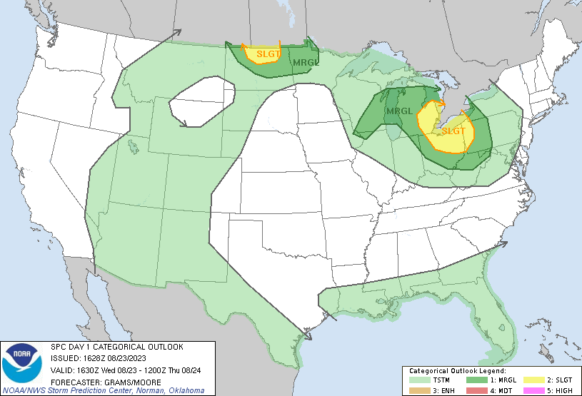
Updated Day One SPC:
Current conditions here in the valley at the Weather Center
That is ridiculous!
I’ve been absent on here lately. Had a death occur. Close friend passed away. Went way too young.
That stinks. Sorry for your loss, Kyle.
Horrendous!
Michael… The blueberry farm on 222 has 30% off their smoothies… They are a soft yogurt base… Very good. Either blueberry, raspberry, peach, strawberry or you can combo any of them.
17 states are under an Excessive Heat Warning. For those of you keeping score at home, that’s 35.4% of the states in the lower 48.
It is quite something to look at the NOAA map.
Here is a non US based long range guess for this winter season.
https://www.severe-weather.eu/long-range-2/winter-forecast-2023-2024-season-early-look-polar-vortex-el-nino-united-states-canada-europe-fa/
Slim
My current guess is the winter will be similar to last year- warm and dry aside from the lake effect areas. Probably not 110″ of snow again, but I still think above average for GR. That’s my early guess
The official H/L yesterday at Grand Rapids was 78/62 there was no rain fall. The sun was out 53% of the possible time. There were 0 HDD’s and 4 CDD’s the highest wind gust was 20 MPH out of the E. The state high was 83 at Benton Harbor and the state low was 58 at Sault Ste Marie. For today the average H/L at GR is 80/60 the record high of 96 was set in 1947 and the record low of 43 was set in 1951 and 1952. The record rain fall of 1.91” fell in 1910. Last year… Read more »
My point forecast is now down to .03 inches of rain! Rain, what rain? Another horrible forecast!
Yeah, the massive heat dome over the central US is keeping the bulk of the conveyor belt of precip off to our N, NE, and E. Like I said, we just received few sprinkles yesterday.
We had some sprinkles here early afternoon yesterday. The heat and humidity here is not supposed to be as bad as you all to the west and southwest. I am not complaining. Move in day yesterday for MSU freshman. Those who know, stay away from Meijer now through the weekend. They will have every checkout lane open and the lines will be a dozen plus deep. It’s an annual phenomenon that I wish upon no one. Our daughter went back to school last weekend. She went back early because she will be an OSL (Orientation Student Leader). OSLs are assigned… Read more »
MSU Strong!
I was there yesterday moving my daughter in the dorms are small felt like being in a Jail lol.. the place was packed bitter sweet day though I shredded a few tears leaving glad we aren’t doing it today in the heat go Spartans!! INDY
That was us last year. It’s tough to let them spread their wings and soar. I feel ya, bro.
Yeah, the MSU dorms are small and overcrowded. Last year MSU crammed three kids in many dorm rooms, which is ridiculous. Probably doing the same this year.
I moved into Landon hall fall 2017 and we had a heatwave in late September in the mid 90s with no AC… you’d think they could afford AC with the high tuition 😀
They keep talking rain for West MI, but no rain in sight yet! They keep saying risk of heavy rain, yet my point forecast shows less that .1 inches of rain today and then maybe a little early evening? Incredible!