Veterans Day celebrates the service of all US military veterans, while Memorial Day honors those who have died while in military service. Another military holiday that also occurs in May, Armed Forces Day, honors those currently serving in the US military. Having known many who have served over the decades I know it isn’t an easy job, especially for those who served in war zones. Thanks for your service!
Yesterday we set many records in the temperature department, our high was 76° and the low 44°.
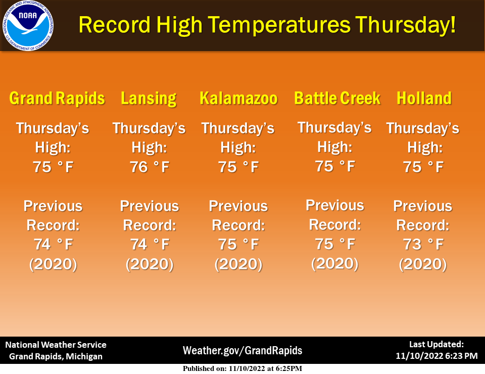
Record high temperatures for November 10th were either broken (or tied) at several locations across our area Thursday!
A surge of arctic air will flow in behind a cold front that passes through the region this morning. While the frontal passage will be dry for most locations today, it will turn cold enough this weekend for lake-effect snow showers to develop. Travel impacts may become possible downwind of the lakes. Temperatures will be 20 to 25 degrees colder than yesterday. Tomorrow through the next week they will be 40° or less for daytime highs and lows in the 20s.
Forecast Discussion
-- Mostly Dry Cold Front Today --

The west-northwest wind shift with the well anticipated surface
cold front will reach West Michigan`s shores before sunrise and
the Lansing/Jackson area by mid-day. Cold air advection below 925
mb will tend to offset the diurnal warming trend in West Michigan
(i.e. temperatures will generally hold or fall during the day),
while Lansing/Jackson may eke out one more fairly mild day near 60
before more efficient cold air advection arrives this evening with
the core of the upper level trough. Sprinkles can`t be ruled out
today in western parts of the area, but mid-level subsidence and
drying on the western periphery of Nicole`s rain shield will work
against our rain chances.

-- Lake Effect Snow This Weekend --

For at least the first half of tonight, the depth of cold air
will be too shallow (inversion heights too low) for lake-effect
precip, but by daybreak Saturday the moisture, lift, and cloud
top temperatures will be adequate for showers to start. A rain or
wet snow mix is expected daytime Saturday, and a few of those
showers could extend far inland by afternoon/evening.

Saturday night will feature the best opportunity for impactful
snow in NW-wind lake effect belts (west of US-131) as the upper
trough axis passes through. The cyclonic polar jet will be
briefly entirely south of our area during that time and deeper
cold air will raise the inversion heights to near the top of the
DGZ. Except for very near the 50-degree lake, temperatures in most
areas will dip below freezing. Streaks of a few inches of snow
accumulation appear likely at this point, with a real chance of
locally overperforming amounts where heavy snow persists. Heavy
snow rates especially at night can overwhelm warm ground
temperatures, so slick roads due to slush or snowmelt refreezing
will be possible (bridges/overpasses susceptible to this first).
Snow showers will linger into the day Sunday but shortwave ridging
will increasingly limit the lake effect potential Sunday night
into Monday.

-- Cold and Occasional Snow Next Week --

The large-scale wave pattern across the central continent,
featuring a tendency for deep and broad troughing, will favor
colder-than-normal weather here for quite a while, and global
model ensembles remain low-spread among temperature solutions
through Thursday. Generally it will be a freeze-thaw cycle with
highs in the upper 30s and lows in the 20s. What is less certain
are the tracks and timing of shortwave troughs moving through the
large-scale pattern which will be responsible for occasional
upticks in both stratiform and lake-effect precipitation from
Tuesday onward. Chance PoPs will populate the mid to late week
forecast with some potential for accumulations, even inland away
from the lake.
Winter in November baby! Nothing better!
Currently 36 in my hood feels like Winter!! INDY
Not sure how long it will last but there is blue sky to the west and northwest at this time. It is now 45 with that clearing to the west and northwest.
Slim
Definitely an impressive day yesterday with regards to all the records broken. +25 degrees above the average high? Wow. On the flip side, to equal those numbers and reach -25 below the days average low it would have had to reached a low of 9 degrees.
Below normal temperatures with snow showers as far as the eye can see who would of thought ?? looks like a December forecast next week … Heloo Winter ….INDY
Rock
On!
Monday Tuesday is looking good for a storm system with snow yes snow everyday the models are coming together nicely over west Michigan time to dust them snow shovels off … Should be a very active strom track over Michigan this winter season for above average snowfall.. Here we go!! INDY
This has to be the warmest start ever for November for just about all locations.
It has to be up there… 2020 was quite warm (and I think either 2015 or 2016 if I remember correctly). Seems that the first half of November has been trending warmer recently.
While a very warm start to November this year was not the warmest first 10 days to any November. I have not checked all past Novembers but the mean this year for the first 10 days of November are. Grand Rapids 53.6°, Lansing 55.1, Muskegon 56.1, Holland 55.2. In 2020 the mean for the 1st 10 days that November was Grand Rapids 55.7, Lansing 55.6, Muskegon 56.5. Holland 56.8. 1975 also had a very warm start to November with a mean for the 1st 10 days at Grand Rapids 58.3, Lansing 58.1. Muskegon 57.5 and Holland 57.2. But none the… Read more »
Wow look at all those record highs! If we didn’t just smash the records in 2020, locations would have been 5-8 degrees above the old high yesterday.
Not sure how old old man Winter really is but we welcome you with open arms to Michigan…Let it snow let it snow let it snow wow weather can change very fast in cold ways thats why I love it!! ❤ INDY
Old man winter is as old as the hills.
Slim
There’s no question winter is going to be making an appearance here in West MI moving forward. The GFS has come more in line with the Euro showing an area wide snow around the middle of next week.
A big THANK YOU! to all the Veterans out there who have served or are serving our great country.
Couldn’t agree more. Thank You to all those have protected us for so many years and I know they aren’t Veterans yet…but thanks to those serving right now!!! May God bless all of you and your families, who serve as well!!!
Yesterday was a record setting day as noted above records were set at all west Michigan major locations. One item that is not stated in the above record is that record warmest minimums were set at Muskegon with a low of just 63 and Holland with a low of 56. At Grand Rapids and Lansing it was the 2nd warmest minimum for the date.
Slim
The official H/L at Grand Rapids yesterday was 75/52 There was no rain fall and 91% of possible sunshine. Here at my house I had a high of 77. For today the average H/L is now down to 49/34 the record high of 73 was set in 1909 and the record low of 16 was set in 1987 the record snow fall amount of 5.8” was in 1995.
Slim