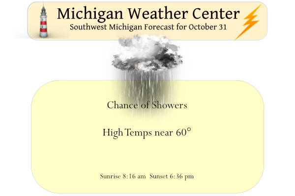
We have a warm 52° at 4 am this morning with .20 of an inch of rain fallen thus far. Yesterday’s high was 63° and the low 34°.
We will see mainly cloudy skies today with shower chances mainly south and southeast of Grand Rapids. It will dry out and the sun returns Tuesday until at least Friday with temps in the 60s.
Forecast Discussion
- Showers Lasting Through This Evening -

The first of a pair of upper level waves continues to move through
the area this morning bringing scattered rain and low clouds. With
PWAT values up towards 1-1.5 inches, moderate rainfall rates will be
possible at times. As the wave lifts north it will weaken and shear
apart, so showers should weaken as they move further north.

The secondary more amplified upper wave will move through northern
IL this afternoon and into southeast MI by this evening. There may
be a brief lull in shower activity this morning before showers
become more numerous this afternoon and evening along and south of a
line from Kalamazoo to Lansing. 24 hour rainfall amounts of up to
0.5 to 1 inch still look possible with the HREF LPMM highlighting
areas along and south of a line from Kalamazoo to Lansing to Flint.
Most areas should be dry by this evening, but some showers may
linger for areas further south near and south of I-94.

- Showers Possible Friday Afternoon/Evening -

Conditions turn dry Tuesday however there could be some fog to start
the day. Persistent upper ridging will support quiet weather through
much of this week before a weak cold front approaches Friday. There
is still a bit of disagreement on the overall evolution of this
system. Between both the GFS and Euro ensembles there seems to be
considerable disagreement on QPF. In general, the front looks to
weaken as it moves through lower MI, then stall out and lift back
north as a more potent cutoff low approaches from the southwest.

- Warmer than Normal Through This Week -

There is still significant agreement among GFS and Euro ensemble
members on warmer temperatures Tuesday through Friday. Given the
uncertainty on the evolution of the late week systems, consensus
on temperatures begins to diverge for the end of the week. Above
normal temperatures will persist through at least Friday.
I would not call it warm but with the dew point in the mid 50’s it dose feel a little humid out today. I would think that there have not been too many Halloween’s that have felt that way here in Grand Rapids.
Slim
Happy Halloween- hoping the rain holds off today. I don’t mind if it is warm or cold on Halloween, but rain is always the worst.
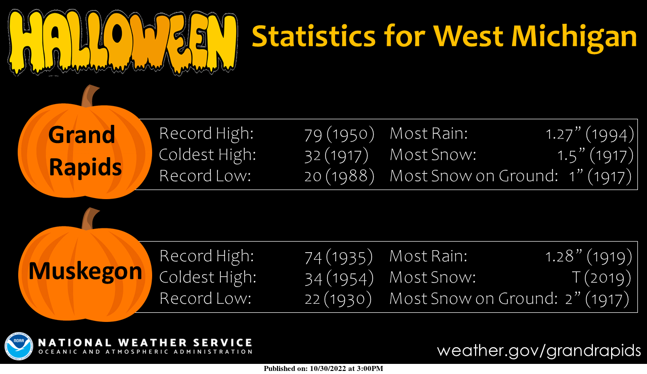
Happy Halloween! Yesterday was yet another warm late October day with the official H/L at Grand Rapids of 62/36 there was no rain fall and 22% of possible sunshine. Last night was a very mild night and the overnight low here in MBY was just 49. It looks like that 49 was also the official low at GRR. I now have a temperature of 50 with some light mist. I had 0.04” of rain fall overnight. For today the average H/L is now down to 54/38 note the average daily high is falling faster than the overnight lows. The record… Read more »
Happy Halloween!
It’s 10 degrees warmer this morning than yesterday morning, which was 10 degrees warmer than Saturday morning.