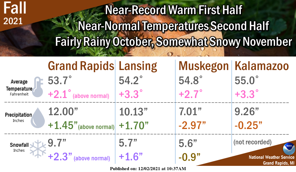
As we look back at climatological fall, the season was remarkably warm (record-breaking at some locations) between September 1 and Oct 15, but after that, it was fairly typical. Otsego had 10.25 inches of liquid precipitation and 7.9 inches of snowfall (which is well ahead of last year’s snowfall.)
Yesterday’s high temp climbed to 52° with a low of 34°.
Saturday will be the best day of the weekend with sunny skies and temps near 40°, Sunday, however, will be a blustery day with winds gusting to over 50 mph in some areas with a mixed bag of precipitation which will change to all rain as the day progresses.
Forecast Discussion
- Rain and snow expected early this morning into today -

Weak low pressure is centered in Eastern Nebraska this morning
with a warm front extending to the southeast into Northern
Missouri. Well north of this front, light rain and snow has broken
out across Wisconsin. The precipitation is being aided by
isentropic lift noted on the 290K surface. Vertical motion is also
enhanced by the right entrance region of a jet streak in the area.
The lift will weaken as we move through the day and as the
precipitation spreads east into our area. So, while we are
expecting precipitation, heavy rain and snow are not anticipated.
Precipitation amounts should be less than a tenth of an inch based
on the probability matched mean values via the HREF. Therefore,
where the precipitation remains snow, totals should range from
little to none up to maybe around a half inch.

- Strong low pressure to move through Sunday into Monday -

The change in the models tonight was for the very deep low that
the ECMWF had Sunday night into Monday to be a bit weaker and more
in line with the rest of the models. The ECMWF still deepens the
low to strong levels, its just well off to the northeast. That
said, looking at the wind gusts via the ECMWF ensembles at
Ludington, the max gust has actually gone up. What this tells us
is that the operational run of the EC may be a bit of a weaker
outlier. In any event, we are going to see a windy time frame from
Sunday into Monday. The mean max gust at Ludington via the 51
members of the ECMWF ensembles is 55 mph. About 8 of the members
have gusts over 60 mph. So, the more likely outcome would be a
gust in the 50-60 mph range.

In terms of precipitation we should see a mix change over to rain
on Sunday as strong warm air advection takes place. There is the
threat of some freezing rain across Central Michigan on Sunday
before the warm air complete invades.

The synoptic scale precipitation will then taper off Monday before
transitioning into lake effect for Monday into Monday night. The
moisture depth looks somewhat shallow in BUFKIT overviews. The
upper pattern quickly goes back to zonal during this time frame
and we lose the upper trough. Not sure how impactful the snow will
be given the loss of significant cyclonic curvature aloft.

- Precipitation still expected Tuesday night -

Some light snow is possible Tuesday night into Wednesday as an
upper trough and shortwave slide through the area. Precipitation
in general looks light with this wave.

- Another system for Thursday in active pattern -

The pattern remains active in a zonal upper flow as we head into
mid to late next week. The next in a series of shortwave troughs
moves through on Thursday. We have a mix of rain and snow in the
forecast.
It looks like it is time to review the Facts!
1. Great start to winter!
2. November = below normal temps and well above normal snowfall!
3. Get ready for lows next week in the teens and low 20’s. January cold arriving a month early!
4. Accumulating snow is on the way for next week! Incredible!
5. Winter in West Mi is the best!
6. Rock n roll will never die!
Warm fall leads to another short winter? I’ll take it.
Best kind of snow today, it falls and melts on contact! In just over a couple of weeks, days start getting longer and then Spring is just around the corner!! I’ll take another short, warm winter!!
Our above average snowfall continues outside its beautiful….InDY
Getting some light snow here at this time no accumulation. With that wet snow falling the temperature here is 34.
Slim
What waiit huuu wow more snow falling who said a warm December?? lol…InDY
We are getting hammered with snow as we speak! Incredible!
With the warmth and the very late color change of the leaves, it was a strange autumn. It seems as the years go by, spring and fall are becoming shorter.