Cyclogenesis is the rapid development or strengthening of a low pressure center. A cyclogenesis bomb is where the central barometric pressure drops at least 24 millibars in 24 hours.
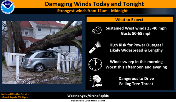
This is the latest from the NWS in regards to the high winds today:
Strong and damaging winds are almost certain today with gusts in the middle of the night across portions of MO and IL to in excess of 60 mph, and the low will only continue to deepen today as it works northeast through the area. A concern is the fact that this low will move on a track closer to our area than the 1998 Fall Storm, the Fitzgerald Storm of 1975 or the Armistice Day storm of 1940. All of those systems tracked further west across Wisconsin. This storm will move across Lake Michigan today which will put the rise/fall pressure couplet and therefore the strongest winds right through our area. Model cross sections in BUFKIT continue to show mixing depths tapping 65 knots around 4,000ft. Winds in excess of 50 mph are a certainty, with 60 mph likely and even higher values possible.
Below is the HRRR model for wind gusts today at 10 meters (33 feet):

This is the point forecast for wind gusts (Allegan County): The blue line is the gusts, the line below is wind speed and direction.

This is a good time to make sure all your mobile devices are charged – the winds are starting to pick up and we will start seeing some snow shortly. I live in a valley but can see the tops of the trees swaying.
You can keep track of current conditions on the front page here – I have a ticker on top with the current warnings for the area. Stay safe……
Great call Rocky on schools being closed I have lost count of days now my gals school being closed lol…And it’s still snowing how could that be …INDY..
We are in for at least a couple straight weeks of mid winter like conditions. This is a sign of things to come and this does no even include the Saturday storm!!!
http://wxcaster.com/gis-gfs-snow-overlays2.php?STATIONID=GRR
What a storm! Wind, cold, snow, near blizzard conditions, horrendous roads, school closings and power outages, but don’t worry, some on here said no big deal!
So all the crews that were here by our house have left. I’m guessing they’re waiting till daylight to replace poles? There are a couple with the tops of the poles still connected to the lines just blowing around in the wind. I’ll try and get some pictures soon if I can get the spot light on hem to light them up.
It’ll be so nice when the warmer weather arrives and you can actually go outside and enjoy the warm temps and the world comes back to life after the death of winter!! So awful being cooped up in the house all day with these terrible winds and cold temps! Looks like another awful Monday and then weekend coming up!! With temps far too cold to go out and do anything outside. The warmer temps are coming, just hold on, the winter misery will be over soon!
The snow just keeps coming up here in northern Kent county! It has been snowing all afternoon and evening up here! The roads are horrendous and the school closings are starting to come in! Still very windy and low visibility! Wow what a storm!
What a wind storm!!
It’s been snowing here since 11:30am, so definitely a snow & wind event for me!
So even bigger trees came down by us now on the power lines. Biggest blue explosions I’ve ever seen! Snapped several telephone poles like twigs, lines down everywhere, what a mess! All generators are now fired up and running.
Good luck and hopefully no house damage!
No house damage. We have the wood burner going and plenty of generator power.
Stay warm and safe. Hope all is ok. It shows for that area power back on Tues 4 PM Hopefully it will come on sooner.
We are still getting hammered with snow and horrible visibilities and even worse road conditions! This is a monster storm!
Major wind storm!! Snow, not really….
What a winter! The snow maps keep getting better and it looks like arctic air by next weekend! Incredible!
They actually keep getting less and less every time you post another one! Keep posting them, maybe we can get my are to the 0 to 2 inch range!! Lol!!! WHO KNEW!?!?
In your dreams! Read or weep baby! Rock n roll lives forever!
https://www.instantweathermaps.com/GFS-php/conussfc.php?run=2019022418&time=PER&var=ASNOW&hour=384
More like read it and laugh!!! Those fake fantasy maps crack me up!!!
Good call on the high wind warning for Kent county! Nothing else this should have been with the flurries we got today to go along with the wind!
Drove back from Sandusky today. What a heck of a 4 hour drive!
I can only imagine! We have come from Missouri and hit snow in Chicago . Nothing could have prepared us for the conditions driving I-196 thru Saugatuck area. It was terrible.
Winter on life support about a week and a half or so left then start getting out the lawn equipment! Love this shortened winter!! Basically a November And February winter! Gotta drive 4 hours nort to find snow!!
There is all kinds of snow where I am. I am ready for Spring.
Thanks for the facts Sandy. The warm weather fanatics hate snow and just can’t admit we are heading for an above normal snowfall season and this is been a wild snowy winter!
Is everyone including the experts still predicting below normal snowfall for GR the season? Wrong again!
What a storm and what a winter! Skiing for at least 10 straight weeks and counting! I love it!
Another swing and a miss for the RDB today with less than an inch of snow here!! Also not sure what snow maps to believe that he is posting?? The first 5 day snow map he posted earlier this morning showed 14 inches of snow for my area, then the next one he posted a few hours later showed around 8 inches for my area, now this most recent one showed 4 to 6 inches for my area!!! LOLLOLOL!! Those maps are hilarious!!
Near white out conditions here the last hour ..
How is that possible?
I tell it like i see it. Looks like a band of moderate snow set up right over head ..
Sounds good – enjoy!
Live web cams from Holland, no snow falling out by the lake either with normal visibilities.
https://www.cityofholland.com/hctv/holland-tv-skycam
Exactly what the models predicted. The wind will blow the snow inland! Who knew?
Amazing cold!
Keep talking about warm Spring weather! We have a ton of winter left! I am makeing plans for skiing and snowmobiling for the nene 2 straight weeks at least!!!!!!!
https://www.instantweathermaps.com/GFS-php/conussfc.php?run=2019022418&time=PER&var=ASNOWI&hour=384
The snow maps look awesome!!!!!
http://wxcaster.com/gis-gfs-snow-overlays2.php?STATIONID=GRR
We are getting pounded in northern Kent county and have seen at least 2inches of snow and poor visibilities. Some schools are in jeopardy for Monday!
Two things looked great today.
1. The MSU basketball team that took it to u of m on their home court. (Sorry u of m fans but you get another chance in a week or so).
2.The RDB model that predicted 2 to 4 inches of snow and near blizzard conditions! For GR! Another bingo! Incredible!
I figured without Langford and Ward (30 ppg), Blue would have won by 15 or more. State’s defense was outstanding in the 2nd half. Only three bench players, though. The starters can’t keep playing that many minutes.
Very good points and the fact MSU overcame 2 of their leading scorers not playing was impressive!
Zero snow falling here, visibility is normal. Here’s a pic of our back yard. Very little snow, you can see the grass poking through. Most of what you can see is ice from all the water in the yard that froze:
http://tinypic.com/usermedia.php?uo=jJm7XUcEEIw0EtE8zX7e2Ih4l5k2TGxc#.XHMgdrJOmhA
And our powers back on! Those were some intense blue flashes when the trees came down on the lines earlier!
Lk effect is rolling in with a west wind it’s snowing and blowing hard again … With all the rain overnight still have over 3 to 4 inches of snow on the ground + today’s I have forgotten what my yard looks like lol.. Stay safe we have the strongest winds blowing now to 10pm on the backside of Bombo Genesis…We have survived a polar vortex 2 Major ice storms and now Bombo Genesis the winter that was supposed to be over called out by so many the snow will keep falling well into March enjoy … INDY…
Don’t worrry Indy the warm weather fanatics said this storm was no big deal and questioned why were in a watch! No big deal, just near blizzard conditions, snow, poor visibilities, 40 to 50 mph winds and very slippery and icy roads! Kent should be in a winter storm warning as we speak!! Incredible storm!
I received a text message early today at 3:24 am about a severe thunderstorm warning. Anyone know if there truly was a warning this morning?
Not here. I heard there was suppose to be and I think on the radar it showed but I honestly am not positive. Maybe you can back up a radar and look at that time.
I got a “Special Weather Statement” email that indicated a line of storms were moving through. I never heard anything while I was sleeping though.
Snow has pretty much stopped here now. I would guess about an inch, but of course it has all blown far away and not accumulated anywhere. Good call going with the high wind warning as this is definitely NOT a blizzard.
Looks like your power should be back on by 4PM
I see that. I was just debating on weather to fire up the generators or not. Guess I’ll wait a little bit yet. At least we have the most critical utility…..WI-FI! Ha!
Highest wind gust here was 45 just before our power went out at 11:30. Of course now with no power I have no way of checking my pws. Guessing by visually looking outside I would say we have for sure topped 50mph several times. Lots of trees snapping all around the area here.
Looking ahead we have a nice little snow storm coming Tuesday and next Saturday even bigger storm showing up on the models that would give all of Michigan probably a Blizzard that is a ways out but models been pretty darn good this winter something to think about….The winter that keeps going INDY..
The peak gust at my house so far today is 39 mph. That’s windy enough for me! I don’t want to know what 50-60 mph will sound like!
Is that still your highest wind gust?
45 is now the highest!
It’s gonna be hard to measure snow… looks too windy to accumulate.. Maybe we will just have to drive around and check for drifts tonight..
No snow. Getting sporadic peeks of sunshine. Just retrieved our trampoline from a couple of houses down. Too windy to pull it back so I used the lawn tractor and a tow strap. Put it near the house and weighted it down with some bags of top soil and salt. Tis breezy!
Good idea to weigh down your trampoline! Glad you were able to retrieve it!
Someone in Jamestown is reporting wind gusts of 55 MPH.
Just think this low pressure would of came up over Ohio about 180 miles or so east we would of had 1978 all over again ..Wow amazing winter we are getting in late February.. INDY…
The low looks to still be near the Sault Ste Marie as their latest reading was 978.4 at their airport and 975.7 at KANJ
Slim
Full out Blizzard out at thee YARDofBRICKS NE side of GR …INDY…
Not quite a “blizzard” here but getting moderate snow fall and blowing snow at this time with a temperature of 31
Here is the NWS definition of a Blizzard
lizzard
(abbrev. BLZD)- A blizzard means that the following conditions are expected to prevail for a period of 3 hours or longer:
Sustained wind or frequent gusts to 35 miles an hour or greater; and
Considerable falling and/or blowing snow (i.e., reducing visibility frequently to less than ¼ mile)
Slim
Well it appears the storm has moved in. Very windy here now and snow is flying. The wind is howling thru here. I wonder what the speed is??
I was wondering same thing. Lol
The latest from GRR was west winds at 36 with gust of 47 the top gust recorded at GRR so far is a reported 49MPH
Slim
Thanks Slim. It is a whiteout here.
Tree just fell on the power lines here. Blinding blue flashes and now the powers out.
What is the windspeed by you?
The official high for Grand Rapids for today will be 46 here at my house it was 41.6 the current temperature here at my house is 33.5 and at the airport the last reading was 35. At this time I am getting of and off light snow showers. It is windy but as of yet not too bad. The lowest pressure at GRR was 987.1 and the latest was 991.3
Slim
It looks like the low is close to the Sault as there last reading there was 979.8 and falling.
Slim
Some crazy waves out at the beach today! Most of the ice has been destroyed already:
https://spyglasscondos.com/live-stream
Those waves are crazy!!
NAM!
http://wxcaster.com/gis-snow-overlays.php?STATIONID=GRR
So is your prediction the 14 inches for our area that it was showing earlier this morning or the 8 inches by Friday that it’s showing now??
What are you talking about and where have you been! I post snow maps for your viewing pleasure. The official RDB snowfall prediction for he current storm was posted yesterday for gr and it was 2 to 4 inches with near blizzard conditions! We are well on the way for another bingo! Incredible accuracy!
What a monster storm!
Looks like Dr Cohen is throwing in the towel on winter too after the first week of March! Better get those Winter sports in during the next week and a half!!
https://mobile.twitter.com/judah47/status/1099657833077972998
Western Michigan (Snow & High Winds Today/Tonight) THE WEATHER PROS SUN FEB 24, 2019 10:20AM UPDATE Rob Guariano ON CALL 24/7 WEATHER HOTLINE 315-925-2500 ========== We have rain going to snow showers the next few hours as the winds crank close to 62mph at times for the occasional snow globe look. The snow is a coating to 1″ by dark and up to 1″ in spots tonight. Winds stay gusty through Noon tomorrow. More snow likely Wednesday. ========== TODAY Wet Snow Showers 12noon to Dark ACCUM 0-1″ FALLING TEMPS TEMPS 31 3pm TEMPS 27 6pm Winds to 62mph ===== TONIGHT… Read more »
Alright, let’s revisit this Thursday! Rocky and his “RDB Model” is saying this model is accurate and a “bullseye”, so let’s all look at this Thursday and see if we get the 14 inches of snow that this is calling for in Northern Kent County, heck I’ll even give it til Friday since it’s a 5 day map! But 14 inches is his call for accumulated snow from now til Friday!
http://wxcaster.com/gis-gfs-snow-overlays2.php?STATIONID=GRR
Oh and it looks like maybe only a week and a half or so of this garbage cold weather and then temps start moderating nicely!
https://weather.com/weather/tenday/l/USMI0344:1:US
https://m.accuweather.com/en/us/grand-rapids-mi/49503/extended-weather-forecast/329374
I expected it to be much worse out than it is. Rain stopped and is drying up. Very windy.
amazing how flexible the trees are –
On this great weekend for Winter sports, I belive someone snapped a pick of Rocky skiing in the rain:
https://www.flickr.com/photos/tritonshowers/4874656459/in/photostream/
Haha looks about right!
So much for the blizzard warning for GR. That winter storm watch for 1” of snow was really strange.
Check this out! High this Sunday in the mid 40’s and the high next Sunday in the mid teens! This along with plenty of snow! Welcome to March and mid winter like conditions! I love it!
Can you say bingo? These totals include the snow for Wednesday! And then after this a possible big snowstorm on Saturday! Buckle up and get ready to rock n roll!
http://wxcaster.com/gis-gfs-snow-overlays2.php?STATIONID=GRR
The forecast discussion is the only thing updated on the NWS GR website. They need to get it together. The warnings on the main page have not been updated. Even if you click on the Watches, Warnings, and Advisories link on the main page, you only see the ones from yesterday. Did the govt shut down again??
Fortunately, we have Michael’s ticket above 😬
Agreed – the NWS Grand Rapids have been having issues with updates for quite some time, don’t know what their problem is – it is frustrating.
It has been updated. They must be a fan of your website.
maybe jealous? Things are a lot more structured here…
*ticker
I can’t even get the GR NWS site to open 🙁 Fortunately, Michael’s site is up and at ’em! Crossing my fingers that everyone keeps their power on….