With the warmth and humidity yesterday in place the stink bugs were making their ghastly appearance in droves covering the house and hanging out near the doors. We don’t want these beasties in our house or anywhere for that matter. I found if I spayed mosquito repellent around the doors they seemed to not like it and moved away allowing us to enter without their stinky little bodies coming in with us. I hate those things….
We have now moved in to October, putting an above normal September to bed (temp and precip wise). We finished the month with 7.13 inches of rain in Otsego.
We now are moving from a summer-like pattern back into fall as we progress into midweek and beyond. I am not seeing frost in the near term however one has to think it can’t be far away.
Today and tonight we have expectations of another round of heavy rain – the heaviest being along and north of I96. This could be another 1 to 2 inch event with perhaps 3 inches in some areas prompting a flood watch for Ottawa – Kent counties on to the north and east. The chance of rain and storms will likely last right on through Thursday so we are looking at a wet start to the month. Temps by Friday will be in the mid 50s.
PM Update:
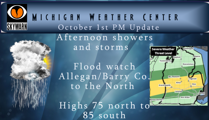
Central Michigan is now included in the slight risk area for storms – the main threat is for heavy rain and wind. Allegan and Barry counties are added to the flood watch..
…we are favoring a more southern track of the storms…which would put these two counties in an increased risk for flooding. Allegan in particular has very saturated conditions from all the recent rain…which would support efficient runoff. Already the storms in Muskegon county have produce upwards of 1.5 inches of rain in an hour. This gives an indication of how efficient the rainfall rates will be for this event.
It is 1:15 AM and it is thundering and lightning with a really heavy down pour. I hope it lets up soon – don’t need this here. We had just made it in from running the dog outside. Good night.
Oh how I wish it were daytime. A pitch black “column/funnel”, (more of a column) rotating counter clockwise , just lowered to tree top level across the backyard moving SSW. It was lit by lightning flashes, and Amway’s parking lot. Probably my only potential “real” weather, and it had to be at night 🙁 Although it was clearly visible. Well…that makes my list of the most fascinating thing within 100 yards of me. Good night all.
ADA – received a half inch of rain today. As of 11pm, quite a good looking light show to the NNW.
High of 79° and a low of 70° in Lansing. That’s good for a +19°. That’s incredible! Super humid to boot. Is this the last day of “summer?”
Yesterday came in at +14 above average, and looks like today will end up at +17 above average with a possible record warm minimum that Slim mentioned below. That would also put the month of October at a ridiculous +17 above.
70′ degrees out at thee YARDofBRICKS NE of GR not going to make mid 80’s today like the NWS called for bust if you ask me it happens …One thing for sure check out radar the rain is building across the lk again with the cold front this will be the 3rd round for me today stay dry ….INDY…
Rained for about 15 minutes, thundered once, a whopping total of 0.12”, and now the sun is out again. Nothing noteworthy here.
Getting very heavy rain with lightning out at thee YARDofBRICKS NE of GR temp is 70* degrees now … Interesting day that’s for sure not nearly as warm as yesterday and today was supposed to be warmer no sun out will do that …INDY!
Here at my house I recorded 0.57″ of rain in that short but heavy shower. Did not notice any thunder here. Temp is now down to 69 here with a DP of 67. The high here today was 77. But guess what the sun is now out.
Slim
Not a drop of rain here yet today, in fact the sun has been peeking out the past hour bringing the temp up another couple up to 79.
Just like that getting more heavy rain out at thee YARDofBRICKS NE of GR I say it again verry wet Fall pattern we are in…Most I can remember in years ….INDY!!
2pm 73* degrees now out at thee YARDofBRICKS NE of GR im thinking 80*s degrees or better is out the window now that the NWS was calling for today why we have more rain moving into the area we are in a slight risk area now for severe storm tonight I’m still thinking the heavy rain will be the story of the day …INDY
Most of the rain today so far has been just to the north of Grand Rapids. The latest temperatue at GRR was a reported 77° with a DP pf 67° The current temperature at Indy’s location and my house is 75 I have a DP of 69 here.
Slim
80 with a 76dp in Otsego
76 dp?? That’s a lot of moisture in the air!
No rain here yet but everything feels damp and wet. 77 temp and 70 dew point, yuck. Spent 3 hours outside and I’m completely soaked in sweat. Just doesn’t seem right being October.
75* degrees out at thee YARDofBRICKS NE of GR with a nother heavy rain shower what’s new lol moving through seeing more clouds then sun today just may keep the temps down let’s hope so ..INDY ….
75 here at my house as well with lots of clouds and some off and on light rain.
Slim
Like I said before the bigger news for the month of September is constant rain we have had seems like every 3rd day it rained don’t it?? look it’s October now and we have another 2-3 inches of rain coming tonight into tomorrow crazzy if you ask me one month from now all this rain maybe snow that would be greatttt ..Like it or not here comes Winter… IWS weather page will be tracking the storms this afternoon into the overnight we have some fantastic weather scarecrows on the IWS weather page even MV stops by sometimes who knows there… Read more »
9 days of thunderstorms for GR in September. Exactly what everyone on here wanted. Amazing!
The rainfall was to variable to say that was the bigger news for the month. The first part of September we were skunked several times from getting any rain as were other areas. GR ended up around 10th place for temps and rainfall, but other locations ended inside of their top 3 all time temps while rainfall totals were less. What is rare is what we have now with dew points in the 70’s and heat index readings like yesterday near 90.
Thanks for all the stats today Slim! One of the warmest September’s ever here and surrounding locations. This year has seen two dramatic pattern changes. The first back in January when it flipped from incredibly mild to well below, and the second back in June when it flipped from months of below to well above average.
Yesterday H/L at Grand Rapids was 84/57. That high of 84 is the 2nd warmest reading for any September 30th at Grand Rapids. So far the low here at GRR has been 69 and if it stay above 69 until midnight we will set a new record warm minimum for October 1st For today the average H/L is now down to 66/47. The record high is 89 set way back in 1897 and the record low is 27 set way back in 1899. The warmest minimum is 68 set in 1971 and the record coldest maximum is 46 set in… Read more »
Oh you know, just another humid summer day in October! Will 2019 end up being our 4th warm year in a row?
Just another it’s only October 1st ??? INDY
Gr has had 7 out of the first 9 months with below normal temps! What a great cool pattern we are in! Keep it coming!
And no 80’s in October who knew? INDY
The month of September was a very warm one. At Grand Rapids the mean for the month was 66.4° that was good for a departure of +3.6. And that is good for the 11th warmest September on record at Grand Rapids. The high for the month was 88 on the 11th and the low was 48 on the 5th there were 10 days with highs in the 80’s 12 days with highs in the 70’s and 8 days with a high in the 60’s it was a wet month with 7.32” of rain fall and that was good for the… Read more »
For September 29th the reported average for the day was 57.0 which should be a departure of 0 but in the monthly daily report the departure is reported as -0.3 and unless that is changed that is what will be in the history books.
https://w2.weather.gov/climate/xmacis.php?wfo=grr
Unless other wise indicated the numbers that I report on come for the NWS. And when I make a mistake I will admit to making one.
Slim
Yep rounded down to zero for an average day. Rule #1 of statistics says that you can’t add more decimal places to your end result than the data group you gathered. Since NWS only measures daily temperatures in whole degrees, any and all decimals when taking averages and such must be rounded to the closest degree.
It should also be noted that averages are also rounded up or down to the nearest degree.
As you know the more warmer days that are recorded the warmer the daily average will become. Sometime in 2021 the new averages will be coming out and look for most of the averages to go up. We have had a lot of warm months in the last 20 years.
Sim
forgot to mention our low this morning was 67 degrees….