Yesterday we started with some light rain and ended with some thunderstorms. We ended up with .78 of an inch of rain which brings our November total to 1.37 inches and 11.13 inches since September 1st. Our high temperature was 48° and the low was 38°.
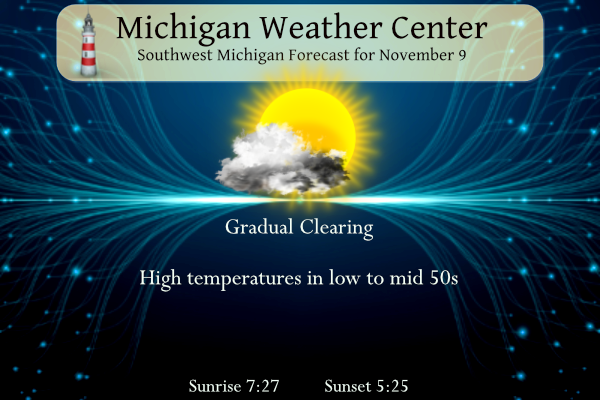
Today we will see gradual clearing with temperatures in the 50s and winds from the west gusting 30 mph.
Forecast
SW Michigan Weather History for Today
1913: A massive storm that became known as The White Hurricane sank numerous ships on the Great Lakes and caused millions of dollars in damage across Michigan. This storm was one of the deadliest and most destructive natural disasters to hit the Great Lakes, killing more than 250 people while wrecking 19 ships and stranding 19 others. The financial loss in vessels alone was nearly five million dollars, or about 100 million dollars at current value. Lost cargo, such as coal, iron ore, and grain was estimated at over 68,000 tons.
SE Michigan Weather History for Today
On November 9, 1913, the Great Lakes was struck by the “White Hurricane.” This November 1913 incredible storm (concentrated on Lake Huron for its death and destruction) was the greatest ever to strike the Great Lakes. No other Great Lakes storm even begins to compare in modern history with its death toll of at least 235 lives and up to forty shipwrecks. For more on this powerful storm see: The White Hurricane.
Also, on this date in 1999, a much tamer record was achived with Detroit having its warmest temperature so late in the season of 75 degrees.
U.S.A and Global Events for November 9th:
1864: On Election Night, a violent tornado strikes a ferry on the Mississippi River near Chester, Illinois, blowing away all but the hull. The boiler and engines are found up the bluff. Half of Chester was destroyed, and twenty died during the storm.
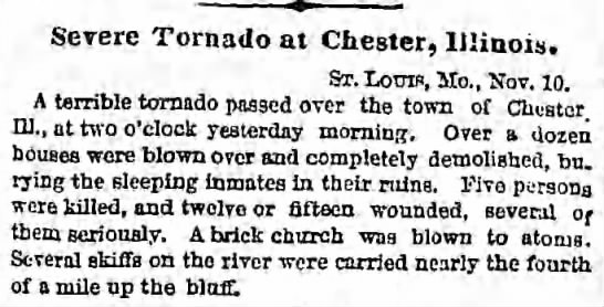
The image above is from The Brooklyn Daily Eagle Brooklyn, New York
November 11th, 1864, Fri • Page 3.
1926: An estimated F3 to F4 tornado tore through La Plata, Maryland, killing 14 individuals at a small school. This storm caused 17 deaths and injured 65 others. Click HERE for more information from the Monthly Weather Review.
Forecast Discussion
After an active period over the last 24 hours with rounds of showers
and storms, we will see much quieter weather settle in for the short
term, valid through 00z Saturday.

Short wave and sfc low responsible for the showers and storms
yesterday, have moved well east of the area already this morning in
the vicinity of Lake Erie. The dominating feature of note for today
and tonight will be the dry slot coming in from the west.

This dry slot is associated with the entrance/confluent region of a
strengthening upper jet that will move across the region. The low
clouds and patchy light drizzle will persist into this morning,
before the low level moisture mixes out. This will lead to mostly
sunny skies by this afternoon, and mostly clear skies tonight.

The upper jet streak will move on by Friday, and we will see a short
wave arrive later in the day. The ingredients to go along with short
wave are not favorable at all for much coverage or intensity of rain
showers through 00z Saturday. Forecast soundings indicate moisture
depth will not be all that deep, being only around 4-5k ft.
Inversion heights around 5k ft agl are responsible for keeping the
moisture layer limited.

Later on Friday as the short wave passes through, 850 mb temps will
be dropping down to around -5 to -6C, providing delta t`s over the
lake around the mid teens C. This will help the cause for a few
showers west of U.S.-131 in the afternoon hours, and into the long
term.

-A Few Lake Effect Showers Possible Friday Night-

Cannot rule out a few lake effect showers near the lakeshore Friday
night into Saturday morning due to cold air advection (with 850 mb
temps falling to near -5C) and a weak shortwave traversing the area.
Capped PoPs at slight chance as moisture depth and inversion heights
are not impressive, being capped near 5000 ft. Looking at thermal
profiles, wet bulb zero heights lower to 1000 ft overnight with sfc
dewpoints just below zero, so cannot rule occasional snow showers
mixing in with any rain showers with wet bulbing effects. However,
given limited moisture and warmer surface temperatures, impacts are
not expected.

-Dry Conditions Saturday Through Mid Next Week-

Conditions dry out for the rest of Saturday into Sunday as shortwave
ridging moves through the upper Great Lakes region before a
shortwave trough passes north of the area Sunday night. Given that
forcing isn`t all that impressive for the CWA and deep layer
moisture is lacking, will leave the NBM PoPs as is with PoPs below
slight chance (10 percent) in our northwest CWA and lower south and
east. This is further supported by little ensemble support for
measurable precipitation.

Beyond the weekend, surface and upper-level ridging moves into the
area Monday and continues to influence our weather through the end
of the long term period. The sensible effects of this weather is
persistent dry conditions for this period. Rising 500mb heights and
associated low-level warm air advection (850 mb temps rise into the
8-10C range) also causes high temperatures to warm into the mid-
fifties by mid next week. This would be above normal for lower
Michigan this time of year with normal highs around 50 degrees for
Grand Rapids in mid November.
Get ready for lows near or below freezing the next 4 nights! Wow!
DDDDD DDDDD DDDDD……Severe Blowtorch warning for next week!! Please see the current CPC OUTLOOK and get prepared now!!! WOOOWWWW!!
55 and sunny here today. A good number of golfers on our course today. They’re aware of the CPC too. They’re going to remain open later than usual this year.
Not weather, but I made it on WOODTV8’s website:
https://www.woodtv.com/news/ottawa-county/welcome-back-community-restaurant-in-zeeland-reopening-after-fire/
Congrats Barry!!
That’s great news! The exterior looks fantastic. Congrats, Barry!
Yesterday was quite the day. Had lightning and thunder in the morning and after sunset the same thing even though the stuff after sunset was vivid and noisy. I don’t think I’ve ever seen a November evening with that much lightning and thunder. Also got an incredible amount of rain some of the most of probably anywhere in Southern Lower MI. Seen some standing water in the backyard last night.
Same here to all of that.
While I did receive a lightning notice on my phone (I did not see any) looks like most of the thunderstorms were to the SE of my house. Not to put any stock into it but here are some weather lore sayings just for the fun of it. Note the part of thunder in November
https://www.stormfax.com/wxfolk.htm
Slim
It sure was gloomy yesterday with lots of clouds there were periods of heavy rain 0.67”. It was cool 44/37 windy at times highest wind 32 out of the E. There was a report of a thunderstorm. For today the average H/L is 50/35 the record high of 77 was set in 2020 the record low of 16 was set in 2003. The record rain fall of 2.53” was in 1966 the most snow fall of 4.0” was in 1894 the most snow on the ground was 7” in 1921. Last year the H/L was 59/36 and there was a… Read more »
At the current time it is partly cloudy and 42 here in MBY. While the official rain fall amount at GRR was 0.67″ here in MBY I only recorded 0.52″
Slim
Get ready for plenty of cold nights! Rock n roll baby!