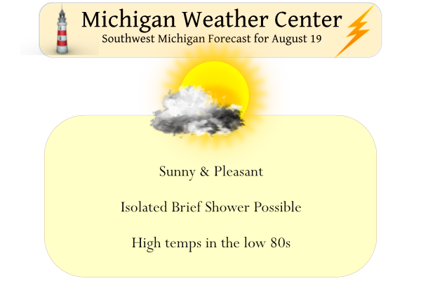
We close out the work week with another pleasant day with highs in the low 80s, a brief popup shower is possible later in the day. Yesterday’s high was 79° and the low 56°. We currently have 59° at 6 am. Sunrise is 6:55 this morning and sunset is at 8:40 pm.
Our chance of showers increases over the weekend.
We are in the marginal risk area for late tomorrow into Sunday:
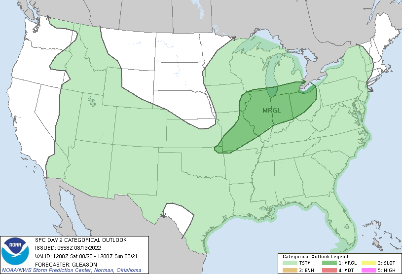
SPC Discussion
 A closed mid/upper-level cyclone over the Upper Midwest Saturday
   morning should devolve into a positively tilted trough as it moves
   slowly eastward across the Midwest, Great Lakes, and mid MS Valley
   through the period. A weak surface low associated with the upper
   trough should likewise move slowly eastward across IA and vicinity
   through early Saturday evening. A cold front attendant to the
   surface low is forecast to progress east-southeastward across parts
   of the Midwest, mid MS Valley, and central/southern Plains.

   A seasonably moist low-level airmass characterized by generally low
   to mid 60s surface dewpoints is forecast to be in place ahead of the
   front. Filtered diurnal heating should aid in the development of
   weak to moderate instability across these regions by Saturday
   afternoon. With mid-level west-southwesterly winds across the warm
   sector expected to mostly range around 25-35 kt, deep-layer shear
   should remain fairly muted. Still, similar values of effective bulk
   shear will probably allow for some convective organization.

   It appears that weak ascent associated with the upper trough/low,
   and modest low-level convergence along the front and pre-frontal
   confluence zones, will encourage multiple bands of loosely organized
   convection to develop Saturday afternoon and continue through the
   evening. Multicells capable of producing isolated damaging winds
   should be the main threat as these thunderstorms spread generally
   eastward. Some marginally severe hail also appears possible with the
   strongest cores given the moderate instability forecast and
   deep-layer shear up to 35 kt, which may support transient supercell
   structures.

   The Marginal Risk for wind/hail has been expanded eastward based on
   latest guidance trends to include more of the Midwest/OH Valley and
   parts of the southern Great Lakes region. Some consideration was
   given for including even more of the OH Valley into the TN Valley in
   low severe wind probabilities, but deep-layer shear should decrease
   with southward extent across these areas. This limits confidence in
   how organized convection will be, so opted to not draw an even
   broader Marginal Risk at this time.
Forecast Discussion
-- Today through Mon --

Latest GOES water-vapor imagery reveals a vort max over central
MN, with RAP mesoanalysis indicating a closed low at 500 mb. In
the low levels, a surface cyclone is consolidating over central
MN, with Lower MI now situated in southwesterly low-level flow.
This system will quickly evolve into a vertically stacked low
today, then progress eastward this weekend. By Sun afternoon, EPS
and GEFS ensemble means indicate that this system will traverse
the CWA--with either a closed low aloft (EPS), or an open-wave
trough (GEFS).

For today, daytime heating, coupled with surface dewpoints near
60F, should yield modest surface-based instability (MLCAPE of
500-1000 J/kg) in inland areas. Most locations will remain dry,
but HREF guidance suggests that isolated showers/t-storms may
develop this afternoon, perhaps initiated by differential heating
along the advancing lake "shadow" as southwest flow strengthens
today.

A gradual uptick in shower/t-storm coverage is still expected on
Sat as large-scale forcing for ascent increases ahead of the
approaching deep-layer low and PW climbs to near 1.5 inches.
Deterministic CAMs suggest that several small convective clusters
may affect portions of the forecast area through the day, with
modest instability (MLCAPE of 500-1000 J/kg) by afternoon.
However, weak low-level and deep-layer shear will limit convective
organization.

The Sat night-Sun timeframe will likely be the wettest overall
portion of the weekend as the aforementioned low/trough arrive over
Lower Michigan. Modest instability and shear will again limit the
risk of severe t-storms. However, locally heavy rainfall is
possible, particularly during the daytime on Sun. The combination of
deep moisture, tall/skinny CAPE profiles, and a deep (10-15 kft)
warm-cloud layer will support warm-rain processes and possibly
enhanced rainfall rates. Additionally, weak cloud-layer flow
(under 10 kts) in the vicinity of the midlevel low suggest slow
storm motion. These environmental factors support a risk of
locally heavy rain, and the WPC day-3 marginal risk of excessive
rainfall appears justified.

For Mon, chance PoPs (highest SE) will be maintained. EPS and GEFS
ensemble means have trended somewhat faster with the progression of
the weakening open-wave system on Mon, with subsidence/drying in its
wake. Nevertheless, daytime heating and lingering boundary-layer
moisture may support widely scattered showers/t-storms in the
afternoon/evening.

-- Tue and beyond --

High pressure is expected to build into the region on Mon night,
providing settled conditions into Wed. Global ensemble means
exhibit broad agreement on the large-scale features over North
America by midweek, with a pronounced ridge over the western
Canadian provinces and a deep closed low over NE Canada. A cold
front may approach on Thu, possibly brining renewed precip
chances.
Get ready for more below normal temps and sun next week! What a summer! Wow!
Sneaky, 30 second showers all day.
Had a nice little shower move through this morning. Everyone have a great Friday!!!
Continuation of very the pleasant late summer weather. Yesterdays official H/L at Grand Rapids was 84/59. There was no rain fall and the sun was out 85% of the time. The overnight low here in MBY was 59 at the current time with clear skies it is 61 here. For today the record high of 98 was set in 1955 and the record low of 43 was in 1977. Today looks to continue the pleasant weather pattern but there are increasing chances of some rain (maybe heavy?) over the weekend.
Slim
A nice cool 58 currently with a mix of clouds and sun. I can see a rain shower off in the distance. Looks like some high rain chances again for this weekend. We have been spoiled this summer with nice weather so no complaints from me.