
We had a trace of rain yesterday morning with a high of 80°, the low was 64°. Sunrise today was 6:37 and sunset is at 9:03 pm. Today we will see mainly sunny skies with highs in the mid-80s, tomorrow will be another story.
One or more rounds of thunderstorms will be possible across Lower Michigan on Wednesday. As time goes on, the threat for severe thunderstorms will migrate from northwest to southeast. The later in the day that a thunderstorm develops in your area, the hotter and more humid the day will become. Any thunderstorms that develop could produce locally damaging wind gusts, large hail, perhaps a brief tornado, and potentially heavy rain with some flooding.
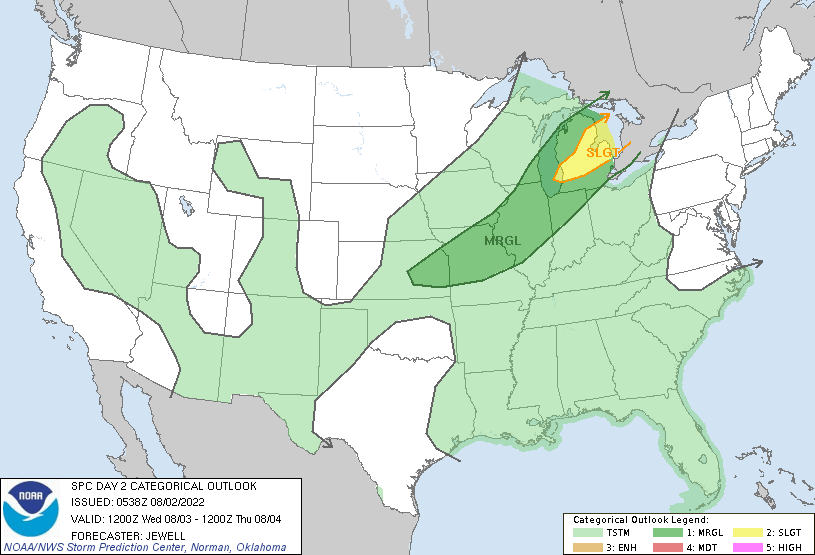
Below is the current outlook from the SPC for tomorrow, and I am sure there may be changes to it as time progresses.
A shortwave trough will affect the Upper Great Lakes region as a
   surface low moves northeastward out of Ontario. A cold front will
   trail southwestward across northern MI, southern WI, and into the
   lower MO Valley. Ample low-level moisture with dewpoints near 70 F
   will combine with heating to produce moderate levels of instability
   ahead of the front.

   Early day convection associated with the low-level jet may produce a
   few strong gusts or marginal hail over MI, as midlevel lapse rates
   will be seasonably steep. Air mass recovery is likely in the wake of
   any early storms, and potential outflow boundaries could locally
   enhance low-level shear. Winds around 850 mb will exceed 40 kt,
   though this, and deep-layer shear, will largely be parallel to the
   front. Models suggest afternoon redevelopment will be robust, with
   damaging gusts and a few reports of marginal hail most likely.
   Mesoscale factors may contribute to a brief tornado threat, or
   low-level rotation with the developing line.
Forecast Discussion
Amid surface high pressure behind yesterday`s cold front, drier air
advecting in from the northwest around 850 mb this morning will
support lower dew points as boundary layer mixing depth increases
today. Far southwest Michigan may not catch much break from the
humidity, however.

Well anticipated and fairly abrupt warm air advection commences
tonight with a southwesterly low-level jet transporting a plume of
air from the western CONUS heat dome. In the vicinity/north of an
advancing warm front overnight, thunderstorms are likely to develop
over WI/upper MI as midlevel lapse rates steepen above a 850-800 mb
layer of moisture transport. Convection-allowing models in the 00Z
HREF have been diverse in their handling of the convection overnight
into Wednesday, though storms threatening the Ludington area by
daybreak if not sooner seems to be where the clustering starts.

Convection-allowing models typically underestimate the longevity and
southward extent of well formed nocturnal MCSs in this pattern.
Since over 2000 J/kg MUCAPE and little inhibition for MU parcels
will be present over the area Wednesday morning, it would not be
surprising for backbuilding to occur late into the morning on the
southwest flank/outflow of whatever MCS evolves. This has big
implications on the temperature/cloud/heat index forecast for
Wednesday, which in the absence of storms, would be a sultry day
with highs in the 90s, dew points in the 70s, and a heat index
nearing 100. When an upper level anticyclone is not well established
in the region and our upper levels are more influenced by a trough
moving through the northern Great Lakes, this is a plausible "heat
advisory bust" scenario. Not knowing how far south the morning
thunderstorms will propagate into Lower Michigan, it seems we should
just be prepared for anything.

If much of the area remains storm-free through Wednesday morning,
2000-3000 J/kg MLCAPE and moderate deep-layer shear will be
available for any convection that may break through an eroding cap
during the afternoon. Hail, damaging winds, and perhaps a tornado
could occur depending on convective mode and line orientation
relative to the shear. Heavy rainfall rates are also likely, so any
training convection (whether it be in the morning or afternoon) may
produce locally substantial totals.

Fortunately a break from the worst of the heat and humidity is still
expected for Thursday and Friday. Another plume of warmer air from
out west may wash over the area on Saturday, then another upper
level trough moving through the northern Great Lakes on Sunday could
support additional showers or thunderstorms.
Breaking news – the GR National weather service has very accurate temp reporting equipment and data! Average temps this summer yet some on here constantly tell us it has been a hot summer! Speaking of a joke – what a joke!
Rock on Indy! Normal temp summer with no heat waves! Absolutely INCREDIBLE!
Wow basically a average Summer happing here in Grand Rapids Michigan who would of thought?? .. Its been easy peasy sofar in the heat department thats fine with me how many days until September?? Summer is going out the window fast INDY
The official H/L at Grand Rapids yesterday was 83/68 officially at GRR there was just a trace of rain reported and there was 21% of possible sunshine. Here in MBY I recorded 0.15” of rain fall. The overnight low both here in MBY and at GRR was 62. For today the record high was 98 set in 1964 and the record low of 46 was set in 1920 and 1927. There is a chance of some heavy rain on Wednesday and it looks like it will be humid and maybe even hot depending on how the morning storms play out.… Read more »
Wow GR hit 83* degrees yesterday only 79* in my hood far from the 100’s that was once predicted on here talk about a jolt… INDY
July temperature averages across the major reporting stations: Lansing +1.7 Detroit +0.6 Flint +1.2
And, of course, GR is the coldest relative to average once again at 0.0. What a joke!
Looking at some other major reporting stations is the Great Lakes area for July 2022. Chicago -0.1, Rockford IL +0.2, Cleveland just like Grand Rapids +/-0.0. Erie PA +0.4. Fort Wayne -0.3. Alpena -0.5, Sault Ste. Marie -1.1. So some locations were cooler than average and some were average and some were warmer than average. As for GR if you have a issue with their reports you can write them and see how they respond.
Slim
Those other stations aren’t really comparable. GR has now been consistently cooler relative to average than the major Lower Michigan stations for a year now (since I began tracking). And probably well longer than that. I don’t really have the time to go back and look. Coupled with their cold weather bias in their write ups (compared to other NWS offices) and the seemingly more conservative leaning of their employees, I’m beginning to wonder if this is exactly what they want to report. As I told you, I’ve written them before – and their response was hardly reassuring. They simply… Read more »
I mean the GRR measuring location has not moved in the last 15 or 30 years so all the temperature data they are collecting daily is from the exact same location. The only difference is the averages are now compared to 1990-2020 instead of 1980-2010, but that is consistent among all locations. So I’m not sure what your point is, that they have been adjusting measurements to be lower in recent years or that their equipment is faulty?
The relative coldness of GR recently is very difficult to try to explain away.
Perhaps, it could be that their new “average” has a lot of years backed into it when the measurement location was different and warmer than where it is now. Moving measurement locations and then comparing today’s data to historical data at another location is definitely not ideal and not good science.
Slim, Thanks for the facts! They always get in the way of the warm weather bias and hype!