The summer flies by and we now begin August. Sunrise today in Otsego was 06:36 and sunset tonight would be at 9:04 which gives us 14 hours and 28 minutes of daylight. Yesterday’s high was 84° and the low 58.5°.
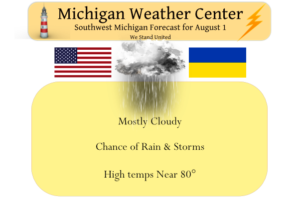
Showers and thunderstorms will be on the increase early this morning. Some of the storms could contain gusty winds. Then for the afternoon, the central area of showers and thunderstorms are forecast to push east of Lansing and Jackson, however, a few lingering light showers could persist. Most locations will end up in the 76 to 81-degree range for high temperatures today.

Forecast Discussion
-- Showers and storms through early this afternoon --

There is not really any change to the expectations for the potential
showers and storms through mid-afternoon for the area. We continue
to look at some lower potential that a few storms may become strong
to severe toward the U.S.-127 corridor and to the east. We agree
with SPC nudging the marginal risk a little to the West for today.

The ongoing showers and storms have showed a slight decrease in
coverage and intensity over the last couple of hours. This is
evident in radar and satellite imagery with cloud tops warming a
little. There is pretty good agreement that there should be a slight
uptick in coverage and intensity of the showers and storms when the
line comes onshore. We believe this has to do with some added
heat/moisture flux coming off of the lake in the SW flow. This seems
plausible with all observed water temps in the low to mid 70s.

Instability will be respectable with MU CAPEs forecast to be over
1,000 J/kg as the short wave moves through. The limitation to this
is that it is not totally sfc based aside from the help from Lake
Michigan. Deep layer effective shear values are on the marginal side
here with values of 25-30 knots. The better chance for stronger
storms will be further east, where some diurnal heating could boost
instability some before the short wave moves through toward 18z. The
window of opportunity for severe weather for our area is kind of
small. If it were to happen, some strong winds would be the most
likely threat.

Clouds will hang on behind the line of showers/storms, with a shower
not out of the question. We will see skies gradually clearing late
this afternoon, and continue through Tuesday as high pressure moves
overhead.

-- Heavy rain potential Wednesday into Thursday --

There is a trend for temperatures to not be as hot on Wednesday,
with the threat for heavy rain increasing a little bit. The trend
for not as hot temperatures is evident as rain chances with the
incoming front are looking more likely to come in a little earlier
in the afternoon on Wednesday.

There will be plenty of heat and moisture over the area, as we will
be in the warm sector by later Tuesday night. It is looking like we
will not see the full potential of warming now with clouds and rain
coming in a little bit earlier. This is all the case as a result of
the models bringing in a short wave and associated low level jet in
a little quicker.

The front will be only slowly moving SE through the area, and will
likely not clear the area until Thu morning. This means we could see
multiple waves of showers and storms move through along the front.
The low level jet does stick around near the area for a good chunk
of this time, although it is not oriented perfectly with the nose of
it moving east overnight. Precipitable water values of over 2 inches
continue to be expected. We will need to watch for the potential of
heavy rainfall, which agrees with the thinking from WPC with the
area in the Excessive Rainfall Outlook for Wed/Wed night.

We should see the front slowly clear the area on Thursday morning,
taking most of the rain with it to our South.

-- Unsettled weather possible around next Sunday --

We can`t rule out a small chance of a shower or storm from late Thu-
Sat at this time. It does look like most areas should stay dry with
typical summer-time temperatures during this period. The small
chances of a little rain would be a result of some diurnal
instability, along with some enhanced convergence near the lake
breeze with an easterly flow expected. A weak ridge of high pressure
aloft will become nearly stationary oriented from WSW to ENE, will
limit the chances with warmer temps aloft.

A better chance for rain will come in centered around the Sunday
time frame. The upper ridge is pushed south a little more as the
main upper ridge builds again over the Plains, and we get back under
the NW flow ahead of the ridge. This scenario will push another
Canadian type of cold front down into the area. At the same time,
the low level flow ahead of the front looks to be tapping plenty of
Gulf moisture, and interacting with the front.
Lots of predictions on a hot week did we even make 80* degrees today?? I believe its 79* out in my hood currently… INDY
Too funny – how all the warm weather hype goes up in smoke! Maybe one 90 degree day this week in GR! Certainly no heat. Waves are sight! Incredible!
“No heat”
Definitely not100* degrees that was supposed to come .. INDY
Yes
August lose lots of daylight and average temperatures fall September is closer then ever now love it …INDY
I typically think of August as the warmest month (I know it is technically July). Same thing with winter, a lot of times February feels like the coldest month (even though it is January).
At Grand Rapids August has been warmer than July 14 times. The biggest difference was in 1947 when July had a mean of 69.1 and August had a mean of 77.7. The last time August was warmer than July was just last year when August had a mean of 74.3 and July was 12.3. So yes in some years August is warmer than July.
Slim
Welcome to August. July 2022 at Grand Rapids seen a mean temperature that was exactly average. The mean for the month was 72.1 and that was average. The highest reading was 90 and that occurred on 4 different days the low for the month of 52 was on the 10th There was a reported 2.82” of rain fall and that was below the average of 3.86. At Holland their mean was 72.1 for a departure of +0.5 it was much wetter at Holland as they reported 4.51” of rain fall. At Muskegon their mean was 73.4 that was a departure… Read more »
The official H/L yesterday at Grand Rapids was 80/60 there was no rain fall and the sun was out 77% of the time. Here in MBY the overnight low was a warm 70 and at the current time it is 72 there are a few showers to the west of here but not sure how much if any rain will fall here. For today the average H/L has started it downward trend at 82/63. The record high of 98 was set in 1988 and the low of 74 was set in 1947. The week ahead now looks cooler than it… Read more »
July was a very nice month. 🙂
Rock on Slim! The facts keep getting in the way of all the warm weather fantasies! Basically a normal temp summer so far! Wow just wow!