
Todays Weather Forecast
[columns] [span6]

SW Michigan Forecast
[/span6][span6]
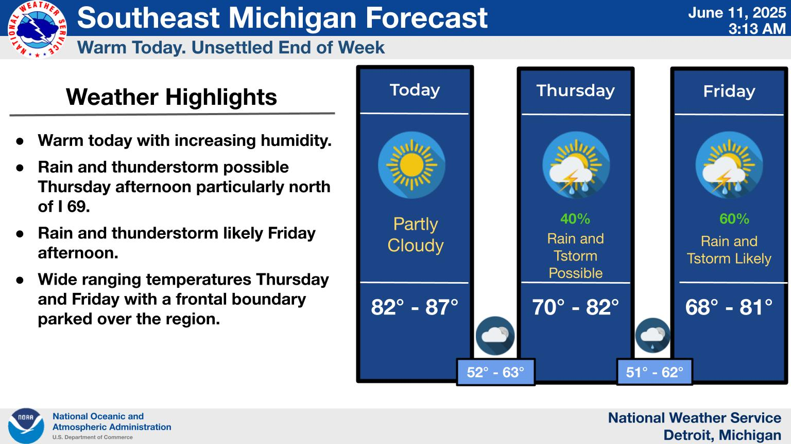
SE Michigan Forecast
[/span6][/columns]
[columns] [span6]
Northern Michigan Forecast
[/span6][span6]
U.P. Forecast
[/span6][/columns]
Forecast Discussion – Northern Michigan
.NEAR TERM...(Today through Tonight)
Issued at 328 AM EDT Fri Aug 14 2020

Impactful weather: None.

Pattern synopsis and forecast:

An upper level weak shortwave/trough was over nrn Michigan early
this morning, underneath overall ridging aloft, while at the sfc, we
still had a ridge axis laid across the region, coming from a center
of high pressure in Quebec. There was still some pockets of mid
level clouds around nrn Michigan, but no precipitation. PWATs were
greater across NW lower Michigan up to 1.25", while the relatively
drier air (just under an inch PWAT) was across mainly the eastern
CWA. Further upstream, larger scale upper troughing was across the
eastern half of Canada and lee side of the nrn Rockies. A deeper
moisture and instability channel was seen lifting up through the
central and northern Plains ahead of this troughing, resulting in
spotty areas of convection.

The sfc ridge axis is going to hold across the region today through
much of tonight, while the weak upper level trough/shortwave lingers
today, before ultimately getting sucked into the larger scale upper
troughing that approaches by late tonight. Not expecting anything
exciting per se as far as weather in nrn Michigan, but considering
the late day shower/storm in the GTV Bay region yesterday, gotta
consider this happening again today within lake breeze convergence
expected in far NW lower this afternoon/early evening, especially
with no apparent cap in place. Also, the approach of the larger
scale trough late tonight, and MUCAPES growing to several hundred
j/kg, are intriguing, but the LLJ/convergence is well north of us.
All-in-all, a chance of seeing a shower or storm across primarily NW
lower and eastern upper is small to say the least, but not
impossible. The chance would be in far NW lower this afternoon and
early this evening (maybe Gladwin/Arenac counties too from Lake
breeze convergence off Saginaw Bay?), and late tonight into daybreak
for eastern upper and mainly along and west of I75 in nrn lower.
Confidence is pretty low and pretty much all areas are likely to see
no precipitation.

Highs today will be in the middle to upper 80s most areas, slightly
cooler lakeshores. Lows tonight will be in the upper 50s to the
lower half of the 60s.


.SHORT TERM...(Saturday through Sunday)
Issued at 328 AM EDT Fri Aug 14 2020

High Impact Weather Potential: Thunderstorms/low-end severe threat
Saturday afternoon/evening.

Pattern Synopsis:

An amplified shortwave will progress from Northern Lake Superior
across Ontario Saturday as a blocking ridge centered over Quebec
tries to hold firm. Additional troughing slides overhead on Sunday
as this ridging exits towards the Atlantic. At the surface, a
cyclone associated with the shortwave will deepen and trek across
Ontario into Hudson Bay by Saturday, sweeping an attendant cold
front down across the Great Lakes through Saturday night.

Forecast/Details:

Confidence has increased in the cold front swinging through the area
Saturday afternoon/evening, which is faster than previous day`s
thoughts. Although low-level flow across the Great Lakes will be
weak, southerlies will help bring a corridor of low/mid 60s
dewpoints into northern Michigan by Saturday afternoon.
Destabilization is expected shortly after noon with daytime heating
through partly cloudy skies in the AM, resulting in instability of
1,000+ J/kg MLCAPE across interior northern lower ahead of the
front. Forecast soundings show somewhat steep lapse rates for the
region, especially in the low-levels, but meager shear will really
hinder more serious severe potential. A severe storm or two can`t be
ruled out Saturday afternoon/evening: however, any stronger storms
that develop will struggle to sustain themselves in an environment
characterized by <25 kts 0-6km bulk shear and wind speeds aloft that
struggle to reach higher than 20kts in the lowest 500mb. When strong
updrafts/cells develop, the expectation is that most will quickly
dump their cores before being able to produce hail sizes aloft large
enough to reach the surface above severe criteria. Inverted-V near-
surface profiles and near 600 J/kg DCAPE could help support some
severe wind concerns, especially when stronger cells begin to
dissipate. The front is expected to move through by Saturday night,
ending any severe concerns at that time.

Uncertainty lies in rain potential on Sunday after the frontal
passage brings low-level subsidence, despite upper-level support and
weak lingering instability. Current confidence is relatively low in
additional rain developing outside of eastern upper and the eastern
half of the forecast area. Otherwise, highs near 80 drop down into
the mid 70s on Sunday heading into a week of much cooler temps
across norther Michigan as of late with sustained northwest winds
behind the front.


.LONG TERM...(Sunday night through Thursday)
Issued at 328 AM EDT Fri Aug 14 2020

High Impact Weather Potential: None

Upper-level troughing is expected to encompass the area from the
Great Lakes up into Hudson Bay at the start of the week while
ridging dominates west of the Mississippi River. High pressure will
continue to build into the region from the northern Great Plains
underneath subsidence aloft provided at the ridge/trough inflection
point. This, combined with low-level moisture being purged from the
region over the weekend, will keep rain chances low through much of
next week. No notable systems will result in relatively weak winds,
thus delayed return flow/moisture return. However, cooler temps have
their sights on northern Michigan through the long term. After the
cold frontal passage over the weekend, afternoon highs look to drop
down into the lower 70s through early next week and may not reach
back into the 80s until the end of next week/next weekend. Some
chillier overnight lows in the mid 40s could bring a slight taste of
fall to the area.
Forecast Discussion – Southern Michigan
-- Hot with a chance of an afternoon showers/storms in the south
 and east --

The upper ridge that has dominated the weather pattern this week
will begin to break down this afternoon. This weakening ridge
will be sandwiched between two upper level low pressure systems.
One, is a weak wave will be moving through the Ohio valley and a
stronger, deeper system that is making its way through the upper
Midwest today.

As the weak system in Ohio moves northeastward, it will bring
moist easterly flow across the Lower peninsula. This will
increase the unstable CAPE to southern Michigan. Couple this CAPE
with the hot daytime temperatures that are expected to be in the
upper 80s to low 90s and you get a chance for showers and
thunderstorms. The latest CAMS have storms sparking after 4 PM.
However there remains several limiting factors. First, is the
remaining stability of the region. That will stifle any
convection from forming. The next is the lack of shear and upper
level forcing. Any convection that does form, will be late in the
afternoon, and will be in the east, near Jackson to Lansing, and
south, perhaps on a very weak boundary south of Kalamazoo.

-- Best chance for storms Saturday evening --


The beformentioned system that is currently moving through the
upper midwest, will trek through Michigan, on Saturday. The front
weakens, with no convection expected through the first half of
Saturday. However, the latest models have the system regaining its
strength as it moves through central Michigan late Saturday.
There is some moisture pooling ahead of it, but given the lack of
diurnal heating and timing, any convection will quickly move into
south east Michigan.

- Cooler and drier trends next week --

We will become under the influence of general trough aloft for
much of next week. This results in much cooler temperatures, and a
mainly dry forecast.

The latest model trends keep the upper jet mainly north and
northeast of the area, on the anti-cyclonic side of the jet. A few
isolated showers can not be ruled out, especially on Monday with a
short wave not far away. However, ridging in the lower levels
being produced by the upper ridge to our west should keep most of
the area dry most of the time. In addition, moisture will be quite
limited once it gets swept out on Sunday.

Temperatures will only get into the mid 70s on Monday, and will
slowly rebound to the lower 80s by Thursday.
https://www.weather.gov/oun/sfcmaps
Current Surface Map.
Crazy radar day. Storms growing in the SE, and moving to the NW :/
We are desperate for rain. They are so close. The sky is black to the south and east.
Wow, I know there are some who think this summer has been hot here but this is from Phoenix
Most days at 115F or better: 7 days and counting (old record 7 from 1974)
Most days at 110F or more: 37 days and counting
Most lows in the 90’s: 20 days and counting (old record 15 from 2013)
I am sure glad I do not live in Phoenix
Slim
I don’t know how one would live in that. You would be stuck inside for the entire Summer.
Yesterday’s official high at Grand Rapids was 86. At my house and at Muskegon the high was 88 and to the east at Lansing it was 85. The overnight low both at the airport and here at my house morning was 64. At this time, it is 66 here at my house.
Slim