[columns] [span4]
[/span4][span4]
[/span4][span4]
[/span4][/columns]
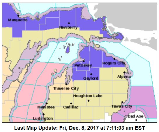
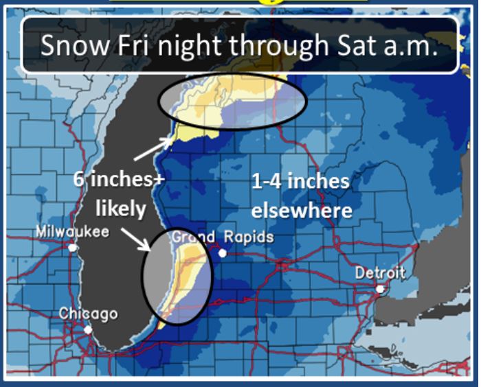 Above are all the winter weather advisories for the state (in blue). There is a winter storm warning for Berrian County (in pink) where heavy lake effect snow expected. Total snow accumulations of 4 to 7 inches, with localized amounts up to 9 inches, are expected. This extends into La Porte and St. Joseph counties in Indiana.
For the lakeshore counties Grand Rapids to the south lake enhanced snow expected. The lake enhanced snow bands will be heavy at times from around midnight till just before sunrise. Plan on slippery road conditions. Total snow accumulations of 3 to 6 inches, with localized amounts up to 10 inches, are expected.
By mid morning Saturday the system enhanced snowfall will end and intense north to south snow band will develop near the Lake Michigan shore from near South Haven and south by the lake shore. Additional snowfall is expected in that area during the day time hours of Saturday.
For Emmet-Cheboygan-Presque Isle counties in northern Michigan the winter weather advisory continues until noon today additional snow accumulations of 2 to 4 inches are expected this morning.
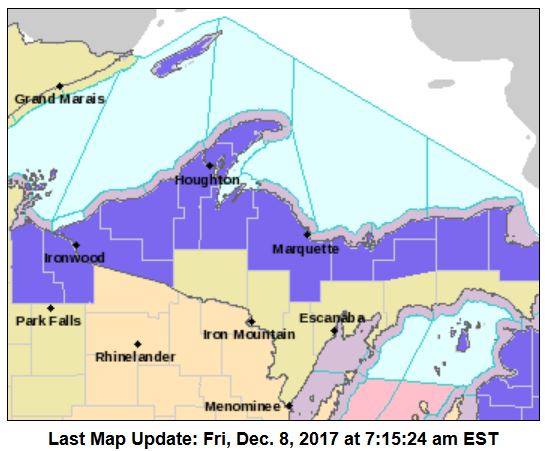
The winter weather advisory for the U.P continues for Alger-Luce-Northern Schoolcraft counties – until 5pm Saturday – total snowfall accumulations of 3 to 6 inches, with localized amounts up to 8 inches, today. Snowfall rates from Munising east could briefly reach one to two inches per hour this morning. Another round of lake effect snow is expected late tonight through Saturday, with additional snowfall accumulations of 4 to 7 inches, with localized amounts to 9 inches.
Today should start out largely precipitation free and temperatures will for stay near to below freezing all day. Tonight a developing storm system will track quickly south southeast from western Lake Superior this evening to central Lake Michigan by midnight. This will bring a period of snow to the entire area overnight. The snow will be heavy at times west of US-131 and south of Muskegon.
The system quickly moves to Lake Ontario by Saturday evening bringing down polar air into the Great Lakes. A narrow band of heavy lake effect snow should mostly stay off shore during the day time hours of Saturday, impacting only extreme western Allegan and Van Buren Counties. High pressure follows for Sunday but the next system will bring more snow Monday into Tuesday and bring down more polar air.
Today: A 40 percent chance of snow showers after 1pm. Increasing clouds, with a high near 32. West southwest wind 10 to 15 mph.
Tonight: Snow showers. Low around 26. South southwest wind 7 to 11 mph. Chance of precipitation is 100%. New snow accumulation of around 2 inches.
Saturday: Snow showers likely, mainly after 4pm. Cloudy, with a high near 31. South wind 7 to 14 mph becoming north in the morning. Chance of precipitation is 70%. New snow accumulation of around an inch possible.
Saturday Night: Snow showers likely, mainly before 7pm. Increasing clouds, with a low around 19. North wind 7 to 9 mph becoming west after midnight. Chance of precipitation is 60%. New snow accumulation of less than a half inch possible.
Sunday: A 40 percent chance of snow showers. Mostly cloudy, with a high near 30. West southwest wind 9 to 15 mph, with gusts as high as 24 mph.
Sunday Night: A 50 percent chance of snow showers. Cloudy, with a low around 26.
Monday: Snow showers likely. Cloudy, with a high near 32. Chance of precipitation is 60%.
Monday Night: Snow showers likely, mainly before 1am. Cloudy, with a low around 18.
Tuesday: Snow showers likely, mainly before 1pm. Mostly cloudy, with a high near 25.
Tuesday Night: A chance of snow showers. Mostly cloudy, with a low around 13.
Wednesday: Snow showers likely. Mostly cloudy, with a high near 27.
Wednesday Night: Snow showers likely. Mostly cloudy, with a low around 20.
Thursday: A chance of snow showers. Cloudy, with a high near 33.
Got about 1.5 inches Here so Far,,,,Snowing Heavy to Moderate as I Type….
Been Having ON & OFF Light To Moderate Snow Here In Allendale For The Last 2 Hrs or So. No WIND To Speak Of, Snow Is Floating Down Peacfully….Very Serene…
Snowing here. They are saying 4 to 6 inches for Saturday.
WHY?? Do My Comments Go To Moderation THEN…Disappear ….HMMMMMMm?….
Starting TO….SNOW Here Just Started. A TUNE for Your FRYday Nite.
Cue::::-:::-
https://m.youtube.com/watch?v=Y-wMGuR3r2U
Hear Is Donald Fagen For Your Ears on This HEAR(pun) FRYday Night…Cut Called “Snowbound”….
CUE —->>>>
https://m.youtube.com/watch?v=Y-wMGuR3r2U
A possible day of skiing coming up for this Sunday! It should be perfect mid winter conditions! Just think a week ago I was golfing in 50 degree temps! Who would have thought?
Not ME…LOL…
We Have Had 6.2 inches of Snow Offically HEAR @ Thee YOCS inAlllendale…..Looks Like We Could Pick UP another half a Foot…Late FRYday Nite into Saturday……Stay Cued……
Welcome to the SNOW belt!
Looks like we are going to get more snow tonight.
INDEED…..
Welcome back!!
Thanks….Sister SANDY!!! Merry CHRISTmas To You and Yours. GOD BLESS….
And then for the next two weeks! Lots of pretty colors right over Lower MI! Get ready!
http://www.instantweathermaps.com/GFS-php/showmap-conussfc.php?run=2017120818&time=PER&var=ASNOWI&hour=372
Awaiting…MODERATION
I’m ……..BACK!!!!!
Stay Cued….
The snowfall maps just give you the basic trend and are not meant to take literally. We are now clearly in a pattern and trend that show COLD and SNOW as far as the eye can see! Welcome to a Rock n Roll winter party!
http://wxcaster.com/gis-gfs-snow-overlays.php?STATIONID=GRR
That’s all good and fine, but you said the same thing last year, and it started snowing on the same day last year, and then the actual long term pattern took hold again after about 2 or 3 weeks. Maybe it’s the start of a new one, maybe it’s not, but none of us will know until about 3 or 4 months from now.
Yes, last year the temps were a little too warm for GR however the Petoskey area was hammered and had above normal snowfall. This year the snowfall will be more widespread and you can count on tons more snow in the GR area than last year!
I know we see snow fall maps the show massive amounts of snow expected for a period of up to several hundred hours and just for the fun of it I looked up the most snow on the ground at 4 Michigan locations. here is the most snow on the ground ever reported by month for Grand Rapids, Muskegon, Lansing and for the fun of it Marquette. For Grand Rapids November 14” in 1940, December 22” in 1951, January 27” in 1978, February 24” in 2014, March 20” in 2014 and April 10” in 1975. Muskegon November 14” 1925, December… Read more »
You never cease to amaze with these weather stats! Those snowfall maps are a joke. If we would get the amount they show, we would be getting 418 inches of snow every Winter. I always wanted to keep track some year and compare them with the actual snowfall. It would be ridiculousl!
Climatology for today December 8th At Grand Rapids, MI
The 30 average H/L for Grand Rapids is 37/26 the 120 average is 36.5/23.8³
The record high is 64° set in 1966 the record coldest maximum is 17 in 1909
The record low is +2° in 2005 the record warmest minimum is 47 in 1966
The most precip is 0.78” in 1966
The biggest snow fall is 4.5” in 1937 the most on the ground at 7 am was 9” in 1909
Last year the H/L was 27/24 1.1” of snow fall was reported at 7 am there was a trace
Slim
MichaelV thanks for removing the annoying capcha. I really appreciate. Makes it much easier to post. The sunshine is beautiful this morning. The calm before the storm.
ya, the capcha was buried deep in the administrator settings – had a hard time locating it….
Yes, Thanks
Slim
For those of you who have had to deal with the annoying capcha to post here it should be disabled now. I also removed the subscription link to cut down on the foreign country’s trying to hack this site.
HEY JACK!!! YOU SHOULD BE ABLE TO POST NOW!!!
Thanks….MV
Still Having Problems….Says Awaiting Moderation ….
Here is the latest long range precip forecast and it is a doozy! With near normal temps during this time frame we will see many feet of SNOW!!
http://wxcaster4.com/cfs/NORTH-AMERICA_CFS-NODE1_SFC_45DAY-ACCUM-PRECIP_180HR.gif
Nothing but green here. Got new Cooper tires on our SUV this fall, and I can’t wait to see how they do in snow.
The event tonight is synoptic in nature and will be very widespread. You can count on seeing a lot of white by Saturday morning! Enjoy! The pattern change has arrived and winter will be ROCKING!
I hope so. We’re leaving shortly for Midland. We’ll be there until Sunday for our son’s hockey tournament.
I love this map! So much for no moisture to work with?
http://wxcaster.com/gis-gfs-snow-overlays2.php?STATIONID=GRR
Lopking Great!
http://origin.wpc.ncep.noaa.gov/pwpf/wwd_accum_probs.php?fpd=24&ptype=snow&amt=1&day=1&ftype=probabilities
The system coming through Saturday morning has a liquid content of .26 which would give most of SW Michigan under 3 inches of snow – this is not counting lake effect because the models (and mets) have a hard time determining where the bands will set up.
We do have several models showing several systems coming through up to and past Christmas – at this time I think SW Michigan would have just under 2 feet on the ground for the holidays.
Snowsuits are ready!!! We had to go out and throw snowballs yesterday!!! LOL!!!
Keep the facts and the good news about snow coming!