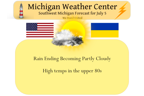
We had .73 of an inch of much-needed rain overnight and early this morning. Yesterday’s high was 90° and the low was 58°, we currently have a warm and muggy 69° at 6 am.
There is still some rain around the area this morning mainly south of Allegan and Barry counties. There is a chance of showers later today mainly south of I96.
Convective Outlook
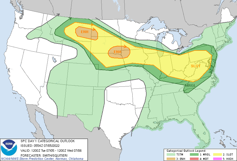
 It seems increasingly probable that a linear cluster of storms will
   be ongoing across parts of the southern Great Lakes/Upper OH Valley
   early this morning.  A seasonally moist and destabilizing airmass
   will reside downstream from this activity across the Mid-Atlantic
   states.  A rejuvenation of storms during the morning into the midday
   or development on the leading outflow are plausible scenarios.  The
   potential squall line would move southeast across the central
   Appalachians and parts of the Mid-Atlantic states this afternoon
   into the early evening.  Strong to severe gusts (50-65 mph) are
   possible in proximity to the stronger cores and surges in the band
   of storms.  This activity may move as far southeast as southern VA
   and NC during the evening with a risk for wind damage before
   weakening.  Farther west over the OH Valley, clusters of storms may
   yield isolated to widely scattered wind damage.
Forecast Discussion
- Mainly dry today...chance for showers/storms this eve/tonight -

Precipitation is sagging south into portions of Indiana and Ohio
this morning and we do not expect significant redevelopment
despite the low level jet being overhead. Not out of the realm of
possibilities that some additional convection develops off of the
top of the cold pool that has set up in the wake of the southward
moving convection though. As of 330am some isolated showers/storms
have formed over Lake Michigan. Any additional development would
most likely be from I-96 to the south which is where the core of
the low level jet resides.

During the morning hours the showers and storms should end with
the low level jet weakening and peeling off to the east by noon.
We will likely see skies become at least partly cloudy in the wake
of the early morning convection.

The next question is whether or not we see showers and storms move
into Southern Lower Michigan this evening. The questions is where
the effective front ends up based on the surging southward line of
storms. We appear to be right on the edge of the chances for
storms and the SPC seems to agree with a gradient to the
categories located over Southwest Lower Michigan. The low level
jet is weak this evening and won`t be much of a help for
additional development. There may be a subtle shortwave at 500mb`s
but there is not much to go on at 500mb either. We will have a
better idea of the threat for storms this evening as we work into
the midday hours and can ascertain where the low level boundaries
have set up. My feeling is that it may be south of our area
despite the HREF showing activity this evening to the south and
west of GRR towards LWA and AZO.

- Next chance for rain exists Wednesday night and Thursday -

West-northwest zonal flow will be in place during this time frame
with the GFS and ECMWF both indicating a weak shortwave moving
through aloft. The GFS is quicker with the wave with the better
chance for precip occurring Wednesday night. The ECWMF is a little
slower and bring the precipitation through more during the day on
Thursday. We have played a bit of a compromise in our forecast and
have the higher pops (50/60 pct) late Wednesday night into
Thursday morning.

- Dry Friday through Sunday -

Ridging noses into the area during this time frame and we should
stay mainly dry. BUFKIT overviews are devoid of deep moisture
during this time. Most of the 51 members of the ECMWF ensembles
also are largely dry during this time.

- Chance for precipitation increase again next Mon and Mon night -

A trough digging into the upper midwest and Northern Great Lakes
will bring our next chance for showers and storms. A surface
trough will also be moving through the area, especially Monday
night into Tuesday. More members than not in the ECMWF ensembles
have precipitation during this time frame. Given the long range
out in the forecast we only have 20-30 pct chances for
precipitation for now.
Breaking news! The high temp in GR was well below 90 degrees! 86 degrees to be exact! All the hype about 90 degrees and not even close! Incredible!
Getting into a more active pattern wet as we approach the middle of July for being the hottest time of the year high 70’s low 80’s not bad at all as far as the eye can see could be worse …Currently the humidity is dropping outside feels tons better then this morning out in my hood … INDY
Thick and humid air outside today. Heat index is back around 90 again. Yuck.
Yeah, I’m not digging the 70+ dewpoints. The breeze doesn’t help either.
Check out the monster bow echo in South Dakota. 96 mph wind gust. I’m glad we’re not getting that.
Wow! Yeah we don’t need anything like that!
ADA – 1/2 inch of rain overnight. Not much, but appreciated. Heard a small amount of Thunder slide past us to the SW.
We sure got some much needed rain last night. Lots of thunder and lightning too. I don’t have a rain gauge I will have to pick up one.
First rain in close to a month with 0.79” and another 90 degree day. It’s been very sunny, hot, and dry for quite a while. I noticed on yesterdays climatological report the record snowfall for July 4 is a trace in 1990. Is that correct??
https://forecast.weather.gov/product.php?site=grr&product=cli&issuedby=grr
That is very interesting. I think that’s a good one for our resident historian, Mr. Slim.
With a H/L of 93/74 I doubt very much there was any snow fall that day. There may have been some hail as there was a reported 0.22″ of rain But there was no snow fall.
Slim
According to the gauge at the Holland airport, they received 1.7 in., a personal station near Hamilton had 1.4 in., and my gauge (2 miles east of Hamilton had 2.3 in. Maybe I need to get a better gauge…
Only received 0.55″ of rain in my neighborhood. Don’t think it’ll have much effect on the drought-like conditions we’ve been experiencing. This was the first rain I’ve recorded in 3 weeks.
My weather station recorded 0.65” of rain last night. It’s 71 and cloudy with a nice light breeze coming through the window.
Looks like we received approximately a half inch of much needed rain. We could use a couple of more nights like that this week.
Agree…my garden will be happy for this rain. I will have to get out there and weed while that ground is wet. Too hard to pull since it has been cement!!
After this week there are hints that there could be a mid summer cool down and that cool down could take us through much of the heart of summer.
Slim
Most of the area finally received a good rain fall. Here in MBY I recorded a total of 0.82” of rain fall in last nights showers and thundershowers. Looks like the official amount at GRR was 0.83” The official H/L yesterday at Grand Rapids was 90/62 there was a total of 0.71” of rain fall before midnight the day had 54% of possible sunshine. For today the average H/L is 83/62 the record high of 101 was set in 2012 (note here in MBY I recorded a unofficial high of 108) the record low of 44 was set in 1972.… Read more »