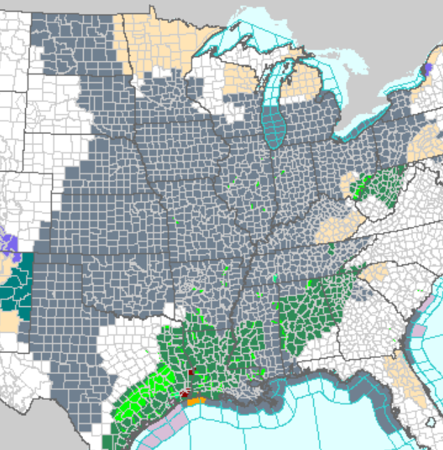
 Our grand January thaw continues and rain on top of that has made a sloppy mess. Here’s an interesting graphic you don’t see often, a good portion of the US has dense fog advisories in place this morning.
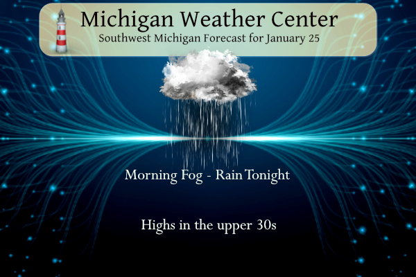
Plan on areas of dense fog during this morning’s commute. A melting snowpack and slightly above-freezing air sets the stage for fog. These conditions will be largely unchanged for the next couple of days. Another round of rain moves in tonight as temperatures remain in the 30s.
Above-normal temperatures are expected over the weekend into next week as our snowpack continues to slowly melt. Rising river levels could lead to some minor flooding.
Forecast
Weather History
1950: Muskegon sets the record high for the month of January at 63 degrees. Grand Rapids also ties their monthly record high of 66 degrees.
1967: Temperatures reach the 60s for the second day in a row across Lower Michigan. However, the spring-like weather is about to give way to one of the greatest snowstorms on record.
On January 25, 2023, a winter storm brought widespread snow from New Mexico through the Ohio Valley and Great Lakes. Heavy bands of snow developed locally with 4 to 9 inches of total snow across most of Southeast Michigan.
On January 25, 1950, the daytime temperature soared to 67 degrees in Detroit. The normal high temperature for January 25 is only 31 degrees!
Also on this date in 2007, an intense lake effect snow band hit the thumb, leaving the Lake Huron shoreline areas with 10 to 12 inches of snow.
U.S.A and Global Events for January 25th:
1821: The Hudson River was frozen solid amid the coldest winter in forty-one years. Thousands of persons crossed the ice from New York City to New Jersey, and refreshment taverns were set up in the middle of the river to warm pedestrians.
1937: Las Vegas, Nevada dropped to 8 degrees above zero, setting a record low for the city.
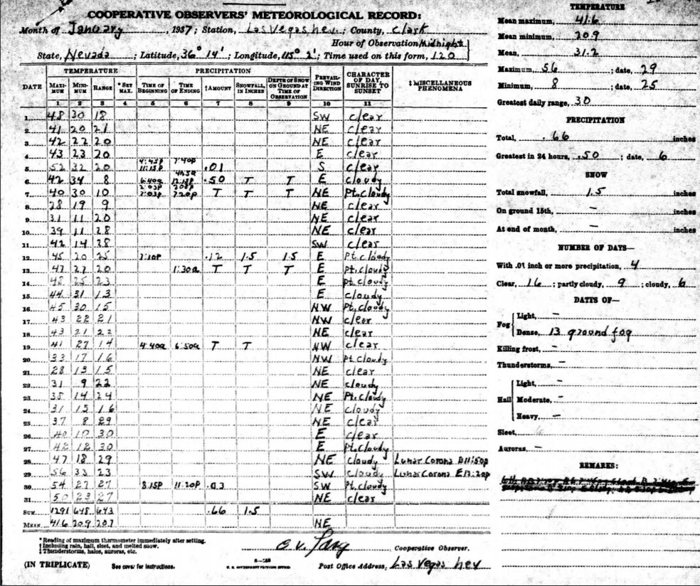
1949: Las Vegas, Nevada, recorded 4.7 inches of snow. This brought the monthly snowfall total to 16.7 inches which still ranks as their snowiest month on record.
Forecast Discussion
- Dense fog into today

We will be holding on to the Dense Fog Advisory as is for this
morning. There was a bit of concern in the evening that the fog was
not extensive enough to justify keeping the advisory. As the rain
has moved out, the light winds have allowed the moist boundary layer
to condense and the fog to become more dense across the advisory
area. The latest short term guidance supports these trends, and
supports keeping the advisory in place for all but the U.S.-10
counties.

A lack of drier low level air around the area and weak January sun
angle will limit the improvement for much of today. As a little bit
of diurnal mixing and increasing wind in the lower levels should
help prevent the dense fog from holding on through the entire day.
Broad ridging aloft in place over the area today will keep
precipitation limited to the mist in the fog.

- Another round of rain Tonight and Friday

The SW flow aloft will continue to feed additional energy and
moisture up into the area for additional rain chances for tonight
into Friday. A fairly robust short wave over the High Plains of TX
and OK this morning will lift NE toward the area tonight. A sfc low
will strengthen as it takes a track near Toledo by 06z Fri and then
NE into Canada beyond that time. This will bring an area of
stratiform rain up into the area from very late this afternoon into
Friday.

This system will bring a nice surge of Gulf moisture over the area
to bring the rain. We will stay under the cool portion of this
system with the warm sector staying well SE of the area. That said,
there is no cold air to speak of with the northern branch of the jet
well north of the area. The only slight caveat to this is up toward
the far NE portion of the area, where they may be near freezing at
the onset of the rain tonight. Most of the data shows it being warm
enough for rain even up there, with only a non-zero chance there
could be a brief period of light freezing rain before going to rain
as it warms.

The heaviest rain looks to occur over the SE portion of the area
near the nose of the low level jet and sfc low. The amounts from
tonight through Friday look to range from just over an inch toward
Jackson, and then tapering off as you head NW.

- Rising rivers and localized minor flooding possible

Our snowpack has likely reached saturation now and has begun
releasing water. This will eventually lead to river rises, but it`s
the round of rain expected tonight that will be what really gets the
water moving toward the rivers.

Tonight into Friday morning should be super sloppy as snow melts and
more rain falls. The water will reach the smaller
streams/tributaries first, and our focus is on the smaller rivers
generally around the Lansing area (Looking Glass, Maple River,
Sycamore Creek, and Red Cedar) for the highest chance to exceed
bankfull and possibly approach minor flood levels by early this
weekend. Eventually this water flows into the main Grand River
itself, which will see large rises, but no significant flooding is
expected.

The other factor to consider is the ice that remains on some of the
larger rivers - specifically parts of the Grand River near Comstock
Park. While the ice remains in place at this time, it`s already
showing signs of losing strength. So while we do expect this ice to
eventually start shifting and moving around, the risk for breakup
ice jams remains fairly low simply because the ice doesn`t appear
that it will have enough strength to cause much of a problem.
However, if you live near an ice-covered river - and especially a
spot with a history of ice jams - now`s a perfect time to pay extra
attention and make a plan for what you`d do if the water started
rising.

- Quieter Pattern for Next Week

Model consensus is for the system on Saturday night and Sunday to
stay primarily south of Michigan, tracking through the Ohio Valley
Rgn. However will maintain low chance pops for rain or mixed rain
and snow near and south of I-96 in case a more northern jog in the
low track occurs.

A generally quieter pattern is expected next week with a
continuation of above normal temperatures but below normal
precipitation amounts. A northwest flow aloft will prevail, with
weaker clipper type systems containing limited QPF occasionally
diving south through the state.

Timing and track of these systems in the northwest flow may change
but currently the first low is shown to come through MI on Tuesday
with a chance of rain and snow showers. Another one looks to dive in
for Wednesday night/Thursday, which also acts to hold back the big
upper ridge to our west from advancing in our direction.

Highs over the weekend into next week are expected to be around 40
with lows 25-35. Normal highs for this time of year are around 30
and normal lows are 15-20.
The melt continues. Grass has reappeared.
I wouldn’t mind a bit of sun, it’s been pretty gloomy. Very typical of Michigan, nothing unusual. But a few days of sun would be great!
Who loves winter? Who is ready for another major snowstorm? Who is ready for the polar vortex?
On m46 today I saw a semi and truck collide at Warner road. Very bad accident, I assume major injuries. It was about 1/4 mile in front of me and I think it was due to low visibility. This fog is no joke and people need to use their low beams so other drivers can see them a little farther out.
Yikes that doesn’t sound good at all. Hopefully everyone comes out ok. I agree, lights on people! And also put the cell phone down and SLOW DOWN.
M46 is still closed 8 hours later. Crazy. I was 3 vehicles behind the accident. Got lucky. Fog is sticking around, especially in depressions near open fields.
So after a brief mini cool down last week, we’re right back to well above normal temps and no snow like it has been all winter so far! The warmth is going to be sticking around for weeks on end!
Breaking News>>>> all signs point towards a return to winter weather around the second week of February, just like I mentioned about a week ago! Get ready to rock! Who wouldn’t want snow in MI in February! Maybe the polar vortex will return! Wouldn’t that be awesome?
Here’s what you said about a week ago about the end of January going into February….
Rocky (Rockford)
Great news! Excellent winter conditions will last all weekend and then after a brief mini warm up, all signs show a cool down by month end with tons more snow! I absolutely love it!
January 17, 2024 9:05 am
He’s already changed the end of the month cool down to mid February cool down LOL what a joke
Next in the historic winter sequence is the Storm team 8 broadcast from 1/25/2014
This was the beginning stages of the Arctic air dump and relentless snow
https://m.youtube.com/watch?v=6qh5QxqIxRw&pp=ygUYc3Rvcm0gdGVhbSA4IGphbiAyNSAyMDE0
Looks great and maybe we will see the polar vortex return this yr around the middle of February! Bring it on! Rock n roll will never die!
Maybe. The CFS weeklies wants to bring colder air in here around the middle of Feb but that’s to far out to know yet though.
Rocky must be hibernating after this prediction he made!
Rocky (Rockford)
Great news…. The so called big warm up will be short lived and then bam right back to cold and snow! I love it!
January 18, 2024 9:02 am
And here is the forecast….
https://weather.com/weather/tenday/l/b523690bfd952b86fef3627c919dd9855281a8da16b83c10bdd381c64ae12cbc
Yikes. What happened to the big snow storm he also predicted for this weekend? Or his snow models showing 2 more feet of snow over the next 2 weeks?
Now he’s pushing his predictions out a week and next week he’ll push those predictions out another week!
Last time I was by the Grand River the river was chucked full of chunks of ice. A little concerned portland may get some flooding. Portland is no stranger to it though. I’ve been by other rivers in the area and they look far better and flowing much better. Maybe things are flowing ok I’m no river expert but has sort of an “ice jam” look. River flooding is why I would absolutely never buy a home near a river.
Just another well above average temp day. Looks like January finishes as another warm month.
How is that possible with all the cold weather hype??
Despite a 10 day blip, the long-term mild trend we’ve seen for years remains in place.
I love it! Keep the warmth ROCKIN!
That’s like 1/3 of CONUS under a fog advisory. That is wild.