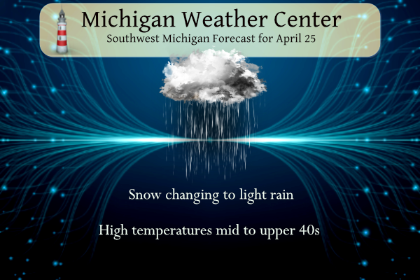
You may be waking up to some light snow showers this morning. This will provide little or no snow cover before changing to periods of light rain later this morning as temperatures warm into the low to mid-40s. We may see some clearing as we get into the late afternoon and evening. This will provide another opportunity for frost overnight. Despite the cool weather, the grass is greening up with the fertilizer I applied last week.
U.S.A and Global Events for April 25th:
1875: New York City received three inches of snow, the latest measurable snowfall on record for that location.
1880: A violent tornado, at times up to 400 yards wide, swept away at least 20 homes in Macon, Mississippi. Pieces of houses were found 15 miles away. 22 people died, and 72 were injured. Loaded freight cars were thrown 100 yards into homes. Clothes were carried for eight miles.
1910: Chicago, Illinois was blanketed with 2.5 inches of snow, and a total of 6.5 inches between the 22nd and the 26th. It was the latest significant snow on record for the city. Atlanta, Georgia also received late-season snowfall when 1.5 inches fell. Their 32 degrees low is the latest freeze on record.
1912: An estimated F4 tornado struck Ponca City, Oklahoma. One person was killed, and 119 homes were damaged or destroyed. Dozens of oil derricks were flattened or twisted, southwest of town. The tornado was reportedly visible and audible for 20 miles.
1990: Thunderstorms produced severe weather from Texas to Nebraska. Thunderstorms spawned fifteen tornadoes, including a powerful F4 tornado near Weatherford, Texas. Between 3 PM and 8 PM, a storm complex tracking northeastward across central Kansas spawned four tornadoes along a 119-mile path from Ness to Smith Center, with the last tornado on the ground for 55 miles. Del Rio TX was hit with hail two inches in diameter and wind gusts to 112 mph. Brown County and Commanche County in Texas were deluged with up to 18 inches of rain, and flooding caused more than 65 million dollars in damage.
Grand Rapids Forecast
425 grrForecast Discussion
--Snow and Rain Mix today--

Another shot of winter is upon us as a large upper level low will
move through the northern Great Lakes today. This will drop 850mb
temperatures to -6C this morning. 07Z Radar is bringing in bands
of precipitation on shore with cloudy skies ahead of it.
Precipitation is currently rain but is expected to transition to
snow towards morning. The central and eastern region should remain
cloudless which is why the freeze warning will be needed through
sunrise. The upper level low will swing a trough through the
region this morning which will increase instability. This coupled
with the influx of moisture, snow is expected just before and
shortly after sunrise.

While temperatures will remain cold, clouds will lift and
temperatures will be warm enough for rain and not snow for any
precipitation this afternoon.

--Morning Freezes through mid week with an end of week warm up--

The roller coaster of temperatures will continue through this
week. Daytime highs will peak into the mid to upper 60s by Friday.
Overnight lows Wednesday and Thursday AM should be below freezing
as clear skies couple with the cold air mass settling over the
region early Wednesday morning. While temperatures will be
slightly more marginal Thursday AM, they should be at to just
below freezing. The cold air mass will move eastward which will
allow temperatures to increase the end of the week.

--Another round of rain possible Saturday evening--

While the ensembles diverge, there is a decent chance for a wave
of precipitation Saturday evening into Sunday morning. Models have
different solutions for placement of the upper level low however
both have precipitation through the region. Lows Saturday night
into Sunday are expected to be in the low to mid 40s so
precipitation should remain rain.
I love it! GR officially recorded accumulating snow today =.2 inches! Wow just wow!
What a day, accumulating snow this morning and now temps barely reaching 40 degrees! The cool pattern is really locked in!
And then throw in a freeze warning for good measure! Wow just wow, WOW!
Ryan Hall Y’all posted a video that discusses what we could see in the long term. Here is the video. Sounds like a pattern change could be in store heading into the first week of May. We shall see. I along with a couple others alluded to this yesterday
https://m.youtube.com/watch?v=p51j8ta1-FA&pp=ygUPcnlhbiBoYWxsIHknYWxs
I watched this last night. It was interesting.
When he said you know deep down what it is.. I was like it looks like a hurricane. LOL!!! I was right… LOL!!!
Ahhhh….April. The mid point of Winter in the Southern Arctic. As May arrives, the snow totals will continue to grow, as do our hopes for relief from the incessant cold. Alas, snow in June will be here soon.
Rock on!
While before today it has only snowed in 8 years since 1893 the last time on this date was in 2013 when 0.2″ fell. The first time it snowed on any April 25 was in 1926 with a trace. For tomorrow April 26th when it also only has snowed in 8 years the last time was in 2022 and in 2021 The first time it snowed on any April 26 was in 1931 and the record is just a trace.
Slim
I should point out that it has only snowed in 8 years on this date since 1893.
Slim
While it CAN snow this time of year, it is becoming a bit more unusual. The last time I seen a solid blanket of snow this late in April I would say was out turkey hunting in I believe it was 2011 and that was I believe on the 18th.
You can remember what you were doing on April 18, 2011? I am impressed. I can’t remember what I did last week. 🙂
Yes, it snowed on April 18, 2011 but that was NOT the last time it snowed on April 18th it also snowed on April 18th in 2022 and again in 2018 both times 0.3″ fell
Slim
Haha yes I have a pretty good memory when it comes to weather and the date things occurred. Where we were turkey hunting was in Barry County east of Middleville and we had a solid inch if not more it was coming down hard.
The ground was solid white this morning on my way to Grand Rapids. The most snow was near Ionia. Looks like February 25th rather than April!
Southern Kent county is getting pummeled with snow!
Some people will say it is a great day for golf! Forget golf and embrace the cold Spring! Above normal snowfall, a cold Spring and now snow in late April! Incredible!
Looks like we won’t see reliable warm temps until may 4-5th. And that is far enough away a lot can change. This temperature has really slowed down spring after the sudden burst caused by those 80f days.
You know it and some will not face the facts!
Snowing pretty decently here right now. The deck and trees are coated
No snow here, although a few flakes fell from the sky yesterday. I’ve mowed twice.
Mowing and snowing = Pure Michigan
Have a great Tuesday my friends, and make someone smile 🙂
Snow is once again falling here at my house with a temperature of 34.
Slim
Let it snow let it snow let it snow let it snow let it snow let it snow let it snow ..great balls of fire …INDY
Where is the warm April weather at? not here with snow falling on April 25th
Slim
We been seeing snow since November no wonder why GR is at #3 snowfall of all time this Winter season whats that favorite saying on here I love long Winters thats the Truth in 2023 …INDY
Wow check out the snow outside great balls of fire ….INDY
Let it snow, let it snow, let it SNOW!!!!!!!!!!
For today the average H/L at GR is 62/41 the record high of 86 was set in 1915 and the record low of 22 was set in 1967. The record snow fall amount of 3.0” fell in 1976. The next 5 days look to have a up and down pattern with some days near average and then falling back to well below average.
Slim
The official H/L yesterday at Grand Rapids was 49/33 There was a trace of snow fall and 54% of possible sunshine. That high of 49 was the 9th coldest high for any April 24th at GR.
Slim
Yes, there is snow on the roofs and tops of cars this morning. For only the 8th time since 1893 there was snow fall on April 25th in Grand Rapids history. The overnight low here in MBY was 30 before the clouds and snow moved in. A total of 0.06” of snow/rain was recorded here.
Slim
Breaking>>>>>current conditions = accumulating moderate snowfall!!!!!!!!!!!!! Rock n roll will never die!
Snow is on the roofs and tops of cars here.
Slim
The ice box continues check out the forecast for this up coming weekend snow and rain showers with temps in the 40’s our early March like weather continues who knew ??? INDY
Rock on and keep the facts rocking!
It has been a very up and down April with some very warm days and then some very cold days. If not for that very warm week the leaves and gras would not be growing as it is.
Slim
Funny how some people keep saying it is warm outside and a warm spring and we keep getting frost/freeze warnings, double digit below normal temp days and SNOW! Let’s review the facts! Above normal snowfall winter and now we are entrenched in below normal temp pattern! Wow, just wow, WOW!!!!!