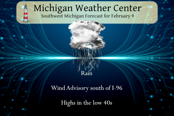
This will be more of an early spring-like day than winter with temperatures rising into the low 50s and copious amounts of rain with the chance of a thunderstorm possible. The winds will pick up this afternoon thus a wind advisory will be in place.
...WIND ADVISORY REMAINS IN EFFECT FROM 10 AM THIS MORNING TO
11 PM EST THIS EVENING...

* WHAT...Winds becoming southwest this afternoon, and then
  northwest by this evening 20 to 30 mph with gusts up to 50 mph
  expected.

* WHERE...Ottawa, Allegan and Van Buren counties.

* WHEN...From 10 AM this morning to 11 PM EST this evening.
...WIND ADVISORY REMAINS IN EFFECT FROM 10 AM THIS MORNING TO
7 PM EST THIS EVENING...

* WHAT...Winds becoming south 20 to 30 mph with gusts up to 45
  mph expected.

* WHERE...Barry, Eaton, Ingham, Kalamazoo, Calhoun and Jackson
  counties.

* WHEN...From 10 AM this morning to 7 PM EST this evening.
Grand Rapids Forecast
1 9 grrLansing Forecast
2 9 lanKalamazoo Forecast
2 9 kzoForecast Discussion
-- Rain and Wind into this evening, transitioning to some snow --

We will be holding on to the headlines for both the Winter Weather
Advisory up North, and the Wind Advisory for the South as is for
the time being this morning.

First thing is dealing with the potential for some freezing rain
up across the interior portions of Central Lower. Rain is
progressing as expected from South to North this morning. No
problems so far with temps having come up a degree or two, and
being solidly above freezing. As the rain moves in across Central
Lower, the four counties in the advisory do have temps 31 and
below with dew points 30 and below.

Temps are forecast to come up gradually, and being below freezing
a bit to start increases the chances of some freezing rain before
temps warm above freezing. Thus, the Advisory looks good
especially that this may affect the morning commute. The 15z end
time also looks good.

Otherwise, the solid band of rain coming in right now will
scatter out as the front and dry slot lift through the area. The
front will bring with it the low chance of some thunder, as is
typical with the edge of the dry slot. Stability indices indicate
that the thunder chance is low with sfc and elevated parcels
approaching thresholds, but not quite there. It may end up being
more of a narrow cold frontal rain band with convective gusts
across the South. It is this scenario, and the dry slot working in
that will give the first potential of gusty winds approaching 45
mph across the southern two rows.

Rain will then fill back in by mid-afternoon as the upper and sfc
lows lift up through the area. Eventually as the lows pass by, we
will see the stronger gradient on the backside move in, and bring
the colder air in. That will gradually change the rain over to
some snow as the precipitation in general tapers off with the
system.

There still looks to be some lake effect snow showers on Friday
with the brief thermal trough of -10C or so coming through, and a
strong secondary upper trough moving through. This should pass
east of the area by 00z Saturday, and bring the snow showers to an
end. Accumulations look to be minimal with this as the sfc temps
are not all that cold with temps in the low to mid 30s.

-- Quiet and mild this weekend into early next week --

Once the system moves by on Friday, we are looking at a fairly
high amplitude ridge building overhead through the weekend. The
brief bout of cold air on Friday, will be pushed out by increasing
WSW winds and allow temps to moderate quickly. Add to that high
confidence of sunshine per good ensemble agreement, and it looks
to be a tranquil weekend.

The quiet weather will continue through the day on Tuesday, but it
will not be as sunny as the weekend. There is actually a fairly
strong wave that will pass through the area on Monday.
Precipitation chances look very limited with it, as there is no
really moisture to speak of in the lower levels. The main thing is
it will just temporarily limit warming.

-- Another potential wet system Tue/Wed next week --

We are looking as a somewhat similar scenario after dark next
Tuesday, as to the current scenario playing out today. A strong
lobe of energy will lift to the NE from the southern Plains to
over the area. There is a good chance the way it shows now that we
will see rain from that system.
Its now up to 43 here in NW GR with some rain and some wind. Not a real nice day but hey one dose not have to shove rain.
Slim
I like how the CPC just keeps those warm temps right over Michigan for weeks on end! Just like a nice warm blanket!! Who wouldn’t want warm temps this time of year!?!?!
Horrendous weather! Nothing worse than a cold, windy rain other than freezing rain!
Who is their right mind would prefer todays weather; temps in the mid 30’s, wind and rain vs a snowstorm? Wow just wow!
For February 9, this is amazing! Not much wind outside yet, and temps are in the mid 40’s, not 30’s, with temps in the 50’s around Kalamazoo and moving North. Just think how much money everyone’s saving on their heating bills!
Mid 30’s? Where? LOL
Upper 30’s here. Temperature has been at 39 here for some time.
Slim
I got 40’s here, not bad!!
Its now up to 43 here, warmer to the south and southeast of Grand Rapids.
Slim
Benefits of this rain is I can finally get a nice car wash for my car. I went to the coin wash the other day to spray the buildup of salt off but that’s as much as I’ll do when roads are a salty mess.
I just ran a couple of errands. I purposely drove through the puddles to drench the undercarriage. Car is washed and it didn’t cost me a darned thing.
Wow the rain is really intense here. That band by you Barry must have moved over here. Lots of ponding of water in my backyard
Just had 20 minutes of really heavy rain and most of the yard is now under water. Still raining but not as hard, should definitely have all the salt washed off the roads now. Best part is no shoveling needed! Let it rain!
Breaking Weather News>>>>>>Winter Weather Advisories have been posted up in Snow country! Get your skies ready to rock n roll! Wow, just wow!
Temps in the 60’s in Louisville this weekend!! Just a short 5 hour drive!! Get your clubs ready and enjoy the courses down there people!! Wow to the wow WOW!!
It looks like March and sounds like April outside with birds chirping and a moderate rain. I’m definitely looking forward to this weekend… sunny and low 40s
I’m planning on getting the grill out and cooking up some meats for Super Bowl Sunday! BRING IT!!
Looks like it will be a great weekend of skiing up in Snow country! Fresh snow is in the forecast! Skiing here I come baby! I love it!
LOL! Winter must be over. Rocky is talking about snow conditions 200 miles up north again…
Yep keep the snow up there! Keep the spring weather ROCKIN here in West Michigan!
One word to describe our current weather pattern is boring. Just a cold rain this morning. Would be nice to get some thunder.
Mark… Wisdom from my Dad… He would say today is a good day if you are a duck!!! Lol!!! He worked outside and I would ask him how is it….this was always his reply on rainy days. Lol. I miss him so much!!
Ain’t that the truth? It’s a great day for water fowl.
LOL!!! Yup.
Thank God it is still winter and we will be seeing more accumulating snow and snowstorms! Incredible!
Lolololol!
50’s and rain and just look at that extended forecast! I love short winters!
Good morning! Yesterday was a rather pleasant February day with an official H/L of 43/24 there was no rain or snow fall and the sun was out 63% of the time. Here in my yard the temperature fell to 31 last night before rising to the current temperature of 35 and at this time there is a cold rain falling. Today looks to be wet for at lest the start before a dry slot moves in and then back to rain later in the afternoon. The weekend looks cooler but still not cold and there is a good chance of… Read more »
Thank God this is all rain today!! Cleans all the salt off the roads and the cars! Gets the ground moisture up for the morels that will be popping in a couple months and best of all I don’t have to shovel rain!
It’s not rain. It’s Matt Kirkwood’s tears from the lack of a winter.
Lol!!!! That is so true Mookie!!