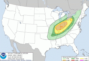
 Our main concern focuses on today with the chance of storms. There is a marginal risk of severe weather across southern Lower
Michigan this afternoon. The main threat will be high winds and
heavy rain.
Low pressure will track south of Lower Michigan today with the chance for strong thunderstorms across far southern Lower Michigan this afternoon. Fair and colder weather will move in on Monday and Tuesday as high pressure builds in.
Yesterday we had a lot of thunder over the south part of the state, enough to delay the Spartan game for three and a half hours, they won over the Nittany Lions 27-24, the Wolverines won over the Gophers 33-10. Severe weather today should stay south of the state in Indiana and Ohio though some may sneak into the extreme south east corner.
This is Winter Weather Awareness week in Michigan, I have a slide show on the forecast page you can check out which describes the various types of storm systems which can affect us along with other info.
Speaking of cold and snow there is a lot of disagreement with the various models I look at everyday with what may be coming for next weekend. The GFS has our first shot of really cold air and perhaps our first accumulating snows of the season with highs only in the 30’s.
The ecmwf has a deeper trough than the gfs. The strength of the high building in behind the cold front is much stronger on the ecmwf than the gfs…1033mb vs 1026mb. As a result, the cold front stalls out on the gfs and never quite makes it through the cwa before moving back north. The cold front on the ecmwf pushes through the cwa.
Much colder air flows in behind the ecmwf front compared to the gfs: ecmwf h8 temps near -14c vs 0c on the gfs. If the ecmwf is correct, Saturday will probably be much colder than advertised. The gfs develops a wave on the front and moves it through the cwa Saturday, but the ecmwf is dry thanks to the strong high pressure over Ontario. Confidence is low toward the end of the forecast period due to the significant discrepancies in the models.
We should have a better handle on this around mid-week – in the meantime we should be enjoying some sun through most of the week in southern Michigan to finish up any yard work which needs to be done.

As far as yard work I will (some date) in the future have a lot of leaves to rake up as the trees in my yard still have many leaves on them. One tree did lose a lot of leaves yesterday. BTW the average (in recorded GR history) of the first 1” snow fall is November 19th with a range of October 12th 2006 to December 23rd 2011. The average for the first 2” snow fall is November 27th with a range of October 12th 2006 to March 18th 1906 and for the first 3” snow fall the average is… Read more »
How are the temps looking for the next 2 weeks? Thanks.