
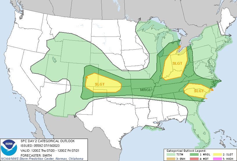
Another mild day today with warm air moving into the region out ahead of an approaching cold front. Highs will be in the upper 70s to low 80s. Showers are storms are expected tomorrow with an approaching cold front. We have a marginal risk that any storms will be severe over the southern half of the state with a slight risk in the extreme southeastern portion.
Weather History for SW Michigan
July 16
1945: The second morning of record cool weather in five days produces low temperatures of 42 degrees at Grand Rapids and Muskegon.
1986: A plane carrying executives from Holland to Muskegon crashed while landing in heavy fog. The pilot had descended below approach minimums and the plane struck two trees about two miles short of the runway. Three people were killed, including the pilot. Three others were injured.
July 17
2006: A widespread severe weather outbreak struck West Michigan. Dozens of trees were downed by winds gusting between 60 and 70 mph. A camper was injured by a falling tree at a campground in Dorr, Allegan County. Two-inch diameter hail fell at Marne in Ottawa County.
2009: The high of 67 degrees at Grand Rapids is a record cool high temperature for the date, and contributes to July 2009 becoming the coolest July on record. The highest temperature for the entire month is only 84 degrees, the lowest monthly maximum temperature for any July on record.
1994: A small, short-lived tornado was observed lifting small debris at the Clare County airport north of Harrison.
July 18
1952: Thunderstorms with heavy downpours resulted in flooding of basements and some streets across West Michigan.
July 19
1894: Temperatures reach 100 degrees across much of Michigan for the second day in a row. At Lansing, the high of 102 degrees ties the record for the all-time hottest temperature.
2009: Cool and unstable air over Lake Michigan spawns at least two waterspouts. One of the waterspouts moves inland near Holland, just north of Lake Macatawa, but quickly dissipates and causes no damage.
July 20
1954: Severe thunderstorms produced golf ball-sized hail and damaging winds across West Michigan. In Kent, Ionia, and Montcalm Counties, dozens of trees were felled and some crops were wiped out by the hail and high winds.
2003: A tornado with peak winds around 100 mph struck near Battle Creek. It left an 8-mile-long damage path and tore a garage from a house. Three outbuildings and a barn were also destroyed. Hundreds of trees were uprooted or broken off. The tornado width was nearly one-half mile wide where the most severe damage occurred.
July 21
1934: A brutal heat wave peaks during the Dust Bowl summer with a high of 104 degrees at Grand Rapids, second only to the 106 and 108-degree readings from July 1936. Temperatures reach the mid and upper 90s even right along the Lake Michigan shore.
1983: One person drowned on the Kalamazoo River as a tornado struck Saugatuck and then crossed the river, generating a large wave of water.
July 22
1953: Severe thunderstorms struck during the late evening as a cold front moved through. High winds downed numerous trees, and several streets in Grand Rapids were blocked by falling trees.
Weather History for SE Michigan
July 16
On July 16, 2021, heavy rain and urban flooding were reported across the Metro Detroit area and Detroit Metro Airport from the daily rainfall record of 2.20 inches. Some areas in Wayne and Washtenaw Counties received over 3 inches of rain.
On July 16, 1980, between the hours of 8:30 AM and 9:30 AM, a powerful derecho swept through Southeast Lower Michigan. Winds were estimated to be up to 100 mph in Washtenaw County and up to 150 mph in Wayne County. Several observers remarked about the horrid dark green color the sky took on as the squall moved overhead. This storm blew out windows in the Renaissance Center. There was only one reported injury, and it was caused by the wind forcing a woman into a revolving door.
July 17
On July 17, 2012, the afternoon high temperature soared to 102 degrees, reaching 100+ degrees in Detroit for the third time that month. Highs also reached 101 degrees in Flint and 100 degrees in Saginaw. All either tied or broke the existing record for the date.
On July 17, 1931, the temperature reached a record high of 100 degrees in Saginaw. Saginaw also had record highs of 98 degrees on the 15th and 16th.
Also on July 17, 2006, a squall line moved across Southeast Michigan hitting the Tri-Cities and Thumb regions the hardest. Severe weather was reported in all seventeen counties of Southeast Lower Michigan. Most of the damage was from severe winds, but there were a few reports of hail up to golf ball size in Saginaw. Winds were estimated up to 100 mph in eastern Huron County as hundreds of trees were snapped or uprooted. One person died, and one person was injured from lightning in Detroit.
July 18
On July 18, 2011, hot and humid conditions gave way to a batch of thunderstorms, with over 20 reports of severe weather across Metro Detroit. The severe reports included a blowdown with dozens of trees snapped northwest of Monroe with winds up to 80 mph. Unfortunately, there was also one weather-related fatality when the high thunderstorm winds knocked down a power line onto a man in Detroit.
On July 18, 2010, A weak EF0 tornado hit Lighthouse County Park in Huron County. The tornado touched down at 10:11 PM with maximum winds of 80 mph. The total path length was estimated at 2 miles, with a maximum width of 75 yards. Numerous trees were blown down, one of which fell onto a camper. Roof damage was also observed at one home.
Also on July 18, 1942, the overnight temperature dropped to only 80 degrees. This is the highest record maximum low temperature ever recorded in Detroit and ties the records set on July 1, 1931, and July 5, 1921.
July 19
On July 19, 2020, several rounds of storms moved through the region, spreading from the Tri-Cities area during the morning to the Metro Detroit area by afternoon. These storms caused numerous instances of wind damage throughout the day as well as heavy localized rainfall. The storms resulted in large trees on mobile homes, damage to structures at Willow Run airport, and an overturned semi-truck near Ypsilanti. Over 100,000 customers lost power due to the storms.
On July 19, 1996, a severe thunderstorm came through Flint producing 58 mph winds in the early morning hours.
July 20
On July 20, 2022, a line of severe storms produced damaging winds across much of Southeast Michigan with Detroit Metro Airport measuring a gust of 66 mph at 3:08 pm.
On July 20, 2021, a line of storms formed along a cold front and tracked from Saginaw Bay southward into the Metro Detroit region. These brought damaging winds and small hail to Lapeer, Oakland, Wayne, and Washtenaw Counties during the late afternoon and evening hours.
On July 20, 2019, severe storms brought widespread wind damage reports across much of Southeast Michigan with approximately 610,000 customers losing power. Some of the hardest hit areas were around Columbiaville where a 72 mph gust was recorded.
On July 20, 1984, Genesee County experienced hail that was 1.75 inches in diameter.
July 21
On July 21, 2011, the peak of the heat wave was reached when high temperatures reached 100 degrees at Detroit, Monroe, Adrian, Grosse Isle, and Ypsilanti. The 100 degrees at Detroit was a record for the date and was the first 100 recorded in Detroit since 1995. This hot day was in the middle of a stretch of heat that saw highs reach 90 or greater at Saginaw for 5 days in a row, 6 days in a row in Flint, and 7 days in a row at Detroit. The heat wave was the longest and strongest heat wave to hit Southeast Michigan since July 1987. It also helped to make July 2011 the warmest month on record for Detroit, the 3rd warmest month for Flint, and the fourth warmest month in Saginaw.
Also on July 21, 1998, during the late afternoon and early evening, a broken line of severe thunderstorms moved through metro Detroit as well as Lenawee and Monroe Counties. This squall line produced a wind gust to 75 mph at the Ann Arbor Airport, widespread wind damage across the metro area especially in Dearborn, hundreds of thousands of power outages, and unfortunately 2 deaths in Woodhaven as severe winds brought down a video store awning. There were also two other injuries at the video store and one injury at Michigan International Speedway (MIS).
July 22
On July 22, 1960, Detroit experienced its highest official wind gust during a severe thunderstorm of 104 mph at 5:18 p.m.
Grand Rapids Forecast
7 19 grrForecast Discussion
.SHORT TERM...(Today through Thursday)
Issued at 317 AM EDT Wed Jul 19 2023

- Warm weather today

Warm air advection will develop today as deeper south to
southwest flow sets up ahead of the approaching front. Model
projections show a 925 mb thermal ridge building into the CWA
today, sharpening as it does. Values are shown to rise into the
low 20 deg C range later today which supports high temperatures
going into the low to mid 80s. Ensemble forecasts also support
those max temperatures, which is what we will forecast. There is a
potential for northern zones to see more in the way of cloud
cover, which raises the uncertainty level for high temperatures
today there.

- Risk for strong/severe storms Thursday

A cold front will be dropping southeastward through the zones
during the day. From the 00z SPC HREF run, MU CAPE values are
forecast to reach into the 1500-2000 J/kg range, with the highest
values over southeast parts of the CWA. A slowly weakening mid
level jet is shown to pivot over the frontal zone as it tracks
through the CWA Thursday afternoon. Still deep layer shear is
shown to be in the 35 to 40 knot range, which is sufficient for
organized convection. Thus we will maintain the potential for some
severe weather in our products. The main window looks to be in the
1 pm to 6 pm timeframe.


.LONG TERM...(Thursday night through Tuesday)
Issued at 317 AM EDT Wed Jul 19 2023

-- Gusty winds into the weekend --

The upper level low that is bringing the cold front Thursday will
continue to move eastward Thursday night into Friday. The upper
level flow will have a convergent gradient that will allow for gusty
northwesterly flow. NBM was not representative in wind strength, so
in coordination with surrounding offices have used a blend including
the CONSraw to bump up the winds. Temperatures will remain in the
upper 70s into the low 80s.

-- Successive troughs will bring chances for showers and storms --

Mild weather will continue overall however several troughs moving
around an upper level situated over northern Canada will bring
chances for afternoon showers and storms. The first of these will
swing through the region Saturday into Sunday. While the downsloping
trough will bring enough instability the latest models have reduced
the amount of moisture so will limit convection development. However
diurnal late afternoon, evening showers and storms remain possible.


 A trough moving through the region Sunday will be deeper and will
have vort maxes associated with it that will bring a higher chance
for showers and storms Sunday into Monday. Latest EC has SB CAPE
peaking around 1500 J/Kg Sunday night into Monday.

This unsettled pattern will keep temperature at to slightly below
normal well into next week.  The unsettled pattern will continue
through next week, which in part is due to a quasi stationary high
that has set up over the four corners and is dominating the inter
mountain west.

Friday through Monday will be a slightly cooler than typical for
July stretch with hotter temperatures seemingly on their way into
Michigan for the second half of next week.
.SHORT TERM…(This evening through Thursday night) Issued at 234 PM EDT Wed Jul 19 2023 Forecast concerns deal with convective trends through the period. A cold front currently moving across the Red River of the North will move across Lake MI Thursday morning. Latest Nam3km develops showers over the lake mid morning and then develops into storms as morning turns to afternoon. HREF is a few hours earlier than that, but the general theme is to develop storms by the afternoon along the front as it moves southeast. Even early over the lake, the GFS shows 600-800 j/kg SBCAPE and… Read more »
A few strong to severe thunderstorms are possible Thursday afternoon and evening with the best chance near and east of US127. Large hail, damaging winds, and locally heavy downpours are all possible in any thunderstorms and a brief tornado cannot be ruled out.
Some rain and thunder tomorrow afternoon would be nice. The last time everything popped a couple of miles to the east of us and we got nada.
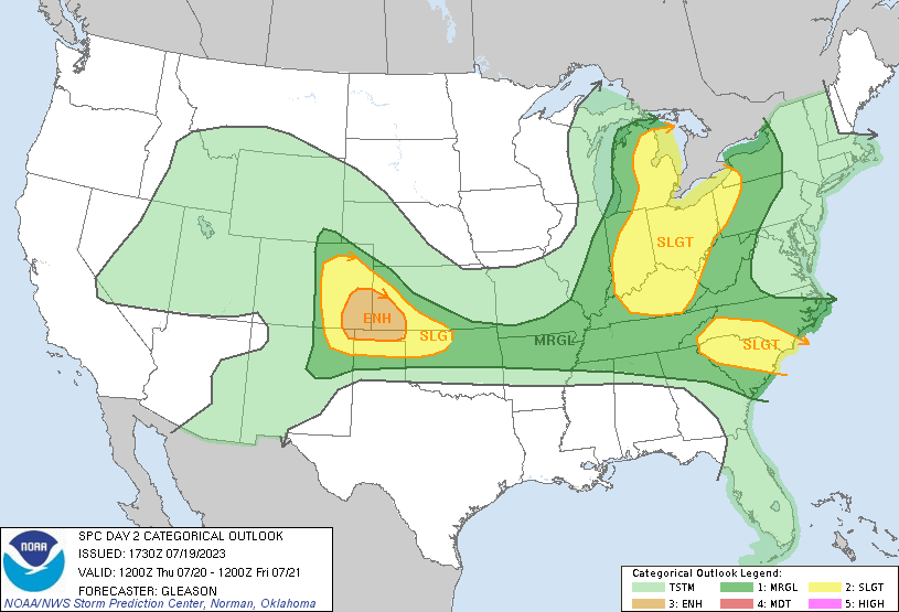
Updated SPC:
More facts! GR is well above normal for precip this month and basically normal for the entire year! Drought?
Facts! GR has seen 3 out of the last 4 months with below normal temps! Incredible!
I love cool summers! Keep this cool pattern rocking right into winter!
Cool is a relative term, IMO. I would not call this summer cool. If I wear shorts everyday and perspire when outside and away from the A/C, that is just not “cool” to me. Has it been cooler than average? In a few areas, sure. A vast majority of areas have been above average.
I figure late May to September is warm, even if it is “below average”. Same thing with late November to March, it is typically cold even if “above average” (of course this is relative to the person too)
We are on track for our 15th warmer than average month in a row! Wow!
70s and 80s isn’t cool in my opinion. 60s would be a different story. It’s been a mild/warm summer. Plenty of 80s ahead which I love.
I’m so glad we’re here. The weather in these parts has been spectacular with temps in the upper 70s and low 80s. Meanwhile, it seems that the rest of our planet is on fire. Records are being smashed in the southern US, but also Europe and Asia. Rome was 107. China had their all time high of 126. So again, let’s count our blessings.
Amen to that!