After getting through the spring and early summer without mosquitoes they are now out in full force making up for lost time. We went to Binder Park Zoo on Friday where it was heavily populated with the flying vampires making for a less than enjoyable experience. If you head that way be aware of road work on I94 from about Fort Custer to Kalamazoo, another treat especially during pm rush hour on a Friday.
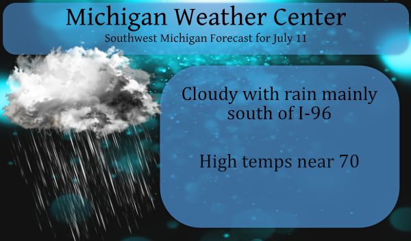
Rain and cooler temps will prevail over southern lower Michigan with rain chances increasing today. Rain will be the main feature for a good portion of the week. We could see some lighting and hear some thunder however any storms should be tame and not reach severe criteria.
Forecast Discussion
-- Occasional shower and eventual storm chances through Tue --

Our weather here in Lower Michigan will be controlled the next three
days by the upper low that is closing off in the IA/MO border area
this morning.

We are seeing the NE periphery of the low and moisture return trying
to make its way up over the area this morning. It has had a hard
time surviving this far north so far, with much of the rain drying
up. This is likely due to the easterly flow holding some drier air
in the lower levels. We will see enough forcing with waves lifting
north over the area that eventually the dry low levels will be
overcome for areas mainly along and south of I-96 today. The thunder
threat has diminished a fair amount for today as compared to what
was expected 24 hours ago. The thunder chance through 12z Mon will
be limited to the very southern portion of the area later tonight.

We will see additional rain showers and some embedded storms then
for Monday into Tuesday. Monday will see additional waves ride up
ahead of the main upper low to our SW. The main associated frontal
system will try to move over the area, but looks to be held just
south of the area. This placement jives well with the severe weather
threat from SPC being SE of the area.

The showers and storms on Tuesday look to be the result of the upper
low opening up, and the resulting wave moving through the area. The
current timing of the passage of the trough by early afternoon would
limit severe weather potential at the moment. Timing of features
with upper lows are frequently problematic. If this trough were to
be delayed some, and come through the area closer to peak heating,
we could see the severe threat increase a bit with the forcing, the
mid level winds favorable, and some instability to be tapped.

-- Round of organized storms possible Wed night into Thu --

It looks like we should see a break in the activity for much of the
day on Wednesday, as we should be in between systems for much of the
day.

The break will likely be short lived as the upper jet remains
nearby, and another decent wave will move over the region by
Wednesday night. This wave looks to be organized enough to help
develop a 45+ knot low level jet ahead of it Wednesday evening. This
would likely produce a MCS to our west, and drive it toward the
state. This is still almost 4 days away, and the timing and movement
of features are still not set in stone by any means. It is something
that could bring decent impacts to the area.

We will see the sfc front associated with the sfc low then drop
through the area on Thursday and Thursday evening. This will keep
the potential for showers and storms in for the area until later
Thursday night. Areas that escape any MCS activity Wednesday night
and Thursday morning would have the chance to destabilize Thursday
afternoon. This could be another possibility of severe weather with
potential ingredients being available.

-- Quieting down toward next weekend --

A residual small chance of rain may linger into Friday with the
upper trough still having to pass through. The chance looks low with
the sfc front having swept the warmer and more moist air to our
south by that time. Once the trough moves through, anti-cyclonic
flow aloft and ridging at the sfc will allow the area to dry out a
bit, with slightly cooler air to filter in for a bit.

Rain showers below normal temps in the middle of July who knew??? INDY
Just another below normal temp day is on tap! Incredible!
After the 10 first days of July Grand Rapids has a mean of 72.6 and that is exactly average after 10 days. The high so far this month is 89 and the low so far is 54. There has been 0.70″ of rain fall and that is below the average of 1.21 after 10 days. At Muskegon they have a mean of 70.4 and that is -1.0 the high/low there so far is 86 and 49. they have had 0.38″ of rain fall 0.84 is average. At Holland the mean there is 70.9 and that is a departure of -0.5… Read more »