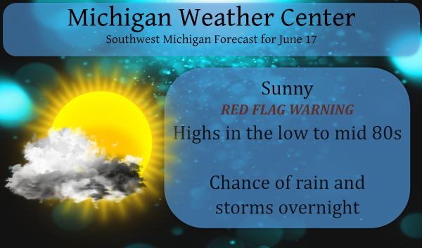
We have a current temp of 45° at 5 am this morning and yesterday’s high was a comfortable 77° with dewpoints in the 40s. For me, this was a perfect day.
The NWS is still calling for an 80% chance of rain for tonight in Southern Michigan and 60% for tomorrow. Rain has been meager for SW Michigan with many areas seeing a quarter-inch or less for the first half of the month. Rainfall totals for overnight may not exceed a half-inch of rain with many areas seeing less than that unless of course, you get a storm. Certainly, no drought buster is on the way…
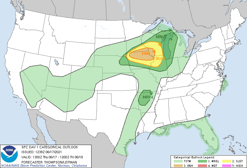
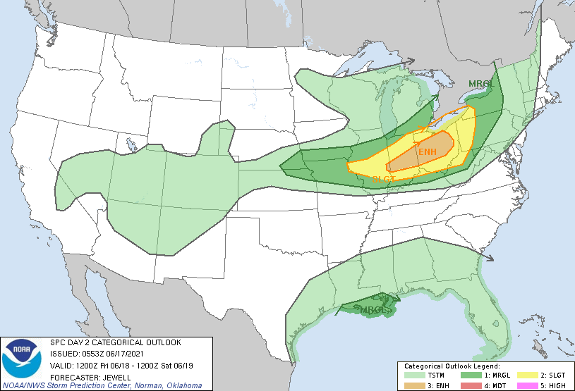
The risk for severe weather exists to the west of us mainly in southern Wisconsin and Iowa. Tomorrow’s outlook shows severe weather to be just south of Michigan.
[columns] [span6]
[/span6][span6]
[/span6][/columns]
Tropical Outlook
[columns] [span6]
[/span6][span6]
[/span6][/columns]
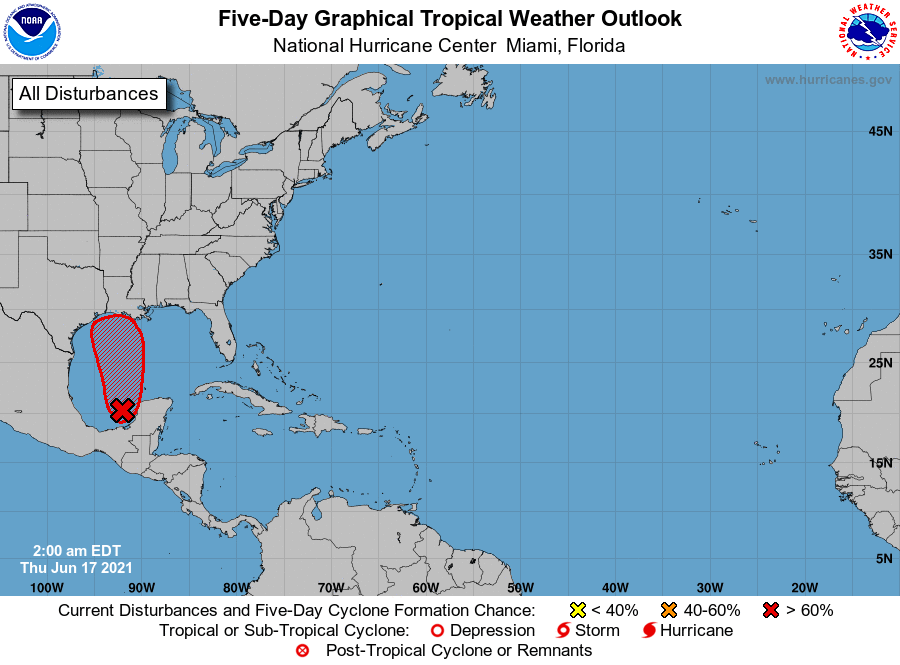
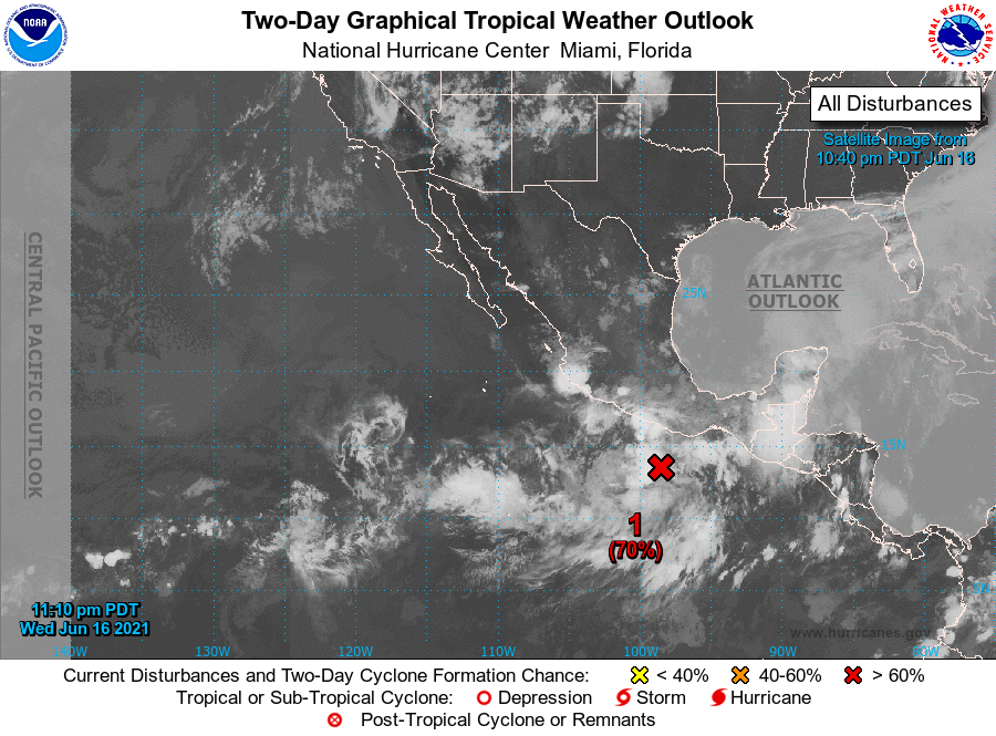
There is an 80% chance of tropical storm development in the Gulf of Mexico and a 90% chance as it begins to move northward towards Louisianna over the next five days. We have another in the eastern Pacific near southern Mexico which has a 70% of tropical storm formation. The central Pacific will remain quiet with no tropical storm forecast.
Forecast Discussion
-Warm and dry today with high fire danger

Very dry air mass remains over MI today with sfc dew pts in the
40s. Warmer high temps in the mid to upr 80s and abundant sunshine
results in afternoon minimum RHs falling to quite low values of
15 to 25 percent. Winds will be a bit stronger today, mainly
north of GRR where some gusts near 20-25 mph may occur later this
afternoon when RHs are lowest.

Fire Weather Watch remains in effect over northern sections
including the Manistee National Forest where fuels remain very
dry. Additional coordination with DNR/USFS and WFO APX later this
morning will determine if upgrade to Red Flag Warning is needed.
Needless to say the potential exists for fires to grow out of
control quickly this afternoon.

-Showers and storms late tonight/early Friday; gusty winds

High amplitude upper ridge over the wrn GrtLks Rgn this morning is
quickly flattened later today/tonight in response to a corridor of
100 kts winds moving along the U.S./Canadian border. Southwesterly
low level jet increases to 45 kts tonight, pushing an impressive
mid level theta-e ridge into the area with PWATs near 2 inches.

This will certainly be a big/abrupt change from today`s dry air
mass and will support a high probability of much needed rain late
tonight as warm front pushes in our direction. However total QPF
likely won`t exceed a half inch in most places.

Severe wx threat tonight is low since strongest convection
expected to be to our west/southwest where the best instability
will be present. HREF ensemble mean MUCape over our area is
generally 500 J/KG or less through the night with much higher
values over srn WI/nrn IL.

However one thing to watch will be the potential for some rather
strong wind gusts to around 50 mph as first batch of LLJ aided
elevated convection rides in atop our antecedent dry low level
air mass. Some of the CAM wind gusts progs bear this out.

Potential for renewed tstm development exists on Friday ahead of
southeastward advancing cold front. Could be a few strong storms
south and east of GRR before fropa where SB capes are shown to
rise to over 2500 J/KG. Limiting factor will be subsidence behind
departing morning convection, with much higher svr wx threat
south of MI.

-Warm weekend; more showers and storms later Sun into Mon

Will have to keep an eye on the wave dropping through nrn Lwr MI
on Sat in nw flow aloft as this could set off a few storms. A much
better chance of of showers and storms arrives for Sunday night
and Monday as northward moving warm front is followed by a strong
cold front and mid level trough. Confidence in timing/impact of
these features is low at this time, but given strength of the cold
front and H5 trough a decent svr wx risk could certainly develop
on Monday.

Although dew points drop off with Friday`s fropa, rather warm
air sticks around through the weekend until the Monday cold front
ushers in below normal temps fro Tue-Wed of next week.
.UPDATE...
Issued at 923 AM EDT Thu Jun 17 2021

After coordinating with the fire weather partners we decided to go
with a red flag warning for the entire cwa. The winds might be
marginal this afternoon for southeast zones but much of the area
is in a D2 drought. Aside from that...the latest day1 outlook from
SPC has expanded the marginal risk for severe weather in our CWA.
The main time period for storms is forecast to start up around
midnight.
No rain here yet.
UPDATE… Issued at 1032 PM EDT Thu Jun 17 2021 Situation is largely unchanged in regard to how convection is expected to evolve tonight. Showers and storms continue to fire upstream and in some instances overhead, but are quickly entrained by dry and lose steam (over Lake Michigan and Western Lower). As we continue to work through the night however this will no longer be the case. High resolution models show the low level jet and 850mb moisture transport increasing overhead as we move through the night. The best chance for showers and storms is still expected to be the… Read more »
Storms…Rain…”what a concept”…
This a good read:
https://www.nbcnews.com/news/weather/heat-wave-west-enters-day-6-entire-state-arizona-soars-n1271166
Does anyone know when we should expect the severe weather tonight?
If (and that’s a big IF) there will be severe weather, it looks like sometime around midnight until very early morning.
https://forecast.weather.gov/product.php?site=GRR&issuedby=GRR&product=AFD&format=CI&version=1&glossary=1
Thank-you. I do see storms in northern Wisconsin but they do not look like they are coming here.
You’re welcome, Sandy. I am no expert, and there are people here that are far more smarter than me. If I had to guess, I think the best chances of any storms will be the SW corner of the state. I am hopeful for some rain, though. We’ll take anything we can get at this point.
Sadly, radar doesn’t look very “wet”
updated post – red flag warning and storms tonight.
The SPC has expanded the marginal risk for severe weather to west Michigan.
https://www.spc.noaa.gov/products/outlook/day1otlk.html
thanks, Mark – perhaps our first chance of severe weather tonight – stay tuned.
👍
Possibility of severe weather late tonight but with the timmin and a cold lake Michigan doesn’t look good but it’s something to track at least it’s been to long ..Like Slim posted another cool night for sure made it down to 50* in my area a perfect fire night loving the cool weather let’s keep it going into July …Have a nice Thursday…INDY
Speaking of fires. I can’t remember the last time there was a red flag warning here. URGENT – FIRE WEATHER MESSAGE National Weather Service Grand Rapids MI 912 AM EDT Thu Jun 17 2021 MIZ045-046-050>052-056>059-064>067-071>074-172115- /O.NEW.KGRR.FW.W.0003.210617T1500Z-210618T0000Z/ Mecosta-Isabella-Muskegon-Montcalm-Gratiot-Ottawa-Kent-Ionia- Clinton-Allegan-Barry-Eaton-Ingham-Van Buren-Kalamazoo-Calhoun- Jackson- 912 AM EDT Thu Jun 17 2021 …RED FLAG WARNING IN EFFECT UNTIL 8 PM EDT THIS EVENING… The National Weather Service in Grand Rapids has issued a Red Flag Warning, which is in effect until 8 PM EDT this evening. * Winds…Southwest 5 to 10 mph with gusts up to 25 mph. * Relative Humidity…As low as 16 percent.… Read more »
The overnight low here at my house was a cool 48. The official overnight low at GRR was 50. Not too far to the north at Cadillac the low dropped to at least 38 for a very chilly mid June night. At this time it is clear and 57 here.
Slim
Local TV met last night said Lansing has received half of the normal precipitation year to date – approx 7.5″ received, which is approx -7.5″.
I have thoroughly enjoyed the past two days. I did a brake job on my sis-in-law’s minivan last night. It was nice to do without sweating my you-know-what off.