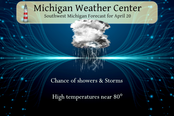
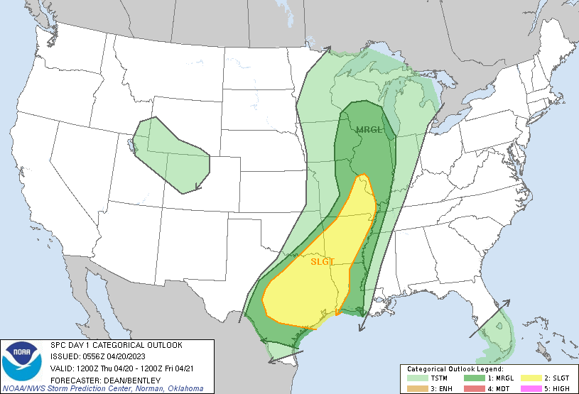
Warmer air will return today albeit briefly. Periods of showers and storms will be possible through tonight. Small hail and briefly gustier winds are possible but severe weather is unlikely. Lows will range from 35 to 50 tonight and highs Thursday will range in the 60s to 70s. Much cooler temperatures will move in for the weekend. We are in the general thunderstorm outlook with a marginal outlook to our south and west.
ENSO Outlook
ENSO-neutral conditions are expected to continue through the Northern Hemisphere spring, followed by a 62% chance of El Niño developing during May-July 2023.
During the last month, above-average sea surface temperatures (SSTs) became more prominent in the western and far eastern equatorial Pacific Ocean [Fig. 1]. The latest weekly Niño-3.4 index value was 0.0°C, but the Niño1+2 index value was +2.7°C, indicating significant warming along the South American coast [Fig. 2]. Area-averaged subsurface temperatures also increased over the past month [Fig. 3], reflecting the dominance of above-average subsurface temperatures across the equatorial Pacific Ocean [Fig. 4]. For the monthly average, upper-level and low-level winds were near normal across most of the equatorial Pacific Ocean. However, low-level westerly wind anomalies were evident in the first half of March associated with sub-seasonal activity. Suppressed convection was evident over the central tropical Pacific and over parts of Indonesia [Fig. 5]. While the warming near coastal South America was striking, the basin-wide coupled ocean-atmosphere system was consistent with ENSO-neutral.
![[Fig. 1]](https://www.cpc.ncep.noaa.gov/products/analysis_monitoring/enso_advisory/figure01.gif)
![[Fig. 2]](https://www.cpc.ncep.noaa.gov/products/analysis_monitoring/enso_advisory/figure02.gif)
![[Fig. 3]](https://www.cpc.ncep.noaa.gov/products/analysis_monitoring/enso_advisory/figure03.gif)
![[Fig. 4]](https://www.cpc.ncep.noaa.gov/products/analysis_monitoring/enso_advisory/figure04.gif)
![[Fig. 5]](https://www.cpc.ncep.noaa.gov/products/analysis_monitoring/enso_advisory/figure05.gif)
The most recent IRI plume favors a transition to El Niño, beginning June-August 2023 and persisting into the winter [Fig. 6]. While the lower accuracy of forecasts during the spring can result in surprises, the recent oceanic Kelvin wave plus recurring westerly wind anomalies are anticipated to further warm the tropical Pacific Ocean. The coastal warming in the eastern Pacific may foreshadow changes across the Pacific basin. Therefore, an El Niño Watch has been issued, and the range of possibilities toward the end of the year includes a strong El Niño (4 in 10 chance of Niño-3.4 ≥ 1.5°C) to no El Niño (1 in 10 chance). In summary, ENSO-neutral conditions are expected to continue through the Northern Hemisphere spring, followed by a 62% chance of El Niño developing during May-July 2023
![[Fig. 6]](https://www.cpc.ncep.noaa.gov/products/analysis_monitoring/enso_advisory/figure06.gif)
U.S.A and Global Events for April 20th:
1912: A tornado moved north-northeast from 5 miles southeast of Rush Center, KS across the east half of Bison, KS. Farms were wiped out near Rush Center. The loss at Bison was $70,000 as half of the town, about 50 homes, were damaged or destroyed. There were 15 injuries in town. A dozen farms were nearly wiped out. Debris from the farmhouses was carried for 8 miles. A senior man who made light of the storm was killed with his granddaughter on a farm 2 miles southwest of Bison.
1920: Tornadoes in Mississippi and Alabama killed 219 persons. Six tornadoes of F4 intensity were reported. Aberdeen, Mississippi was hard hit by an F4 tornado that killed 22 people. This same tornado killed 20 in Marion County, Alabama. Nine people in one family died in Winston County, Alabama.
1984: A temperature of 106 degrees at Del Rio, Texas set a new record high for April.
2004: A strong F3 tornado moved across the town of Utica, near LaSalle-Peru in north-central Illinois. This tornado destroyed several homes, a machinery building, and a tavern. The roof of the tavern collapsed, killing eight people inside; many of these people had come into town from nearby mobile homes, seeking sturdier shelter. The tornado dissipated on a steep bluff on the northeast side of the city. Another tornado developed shortly afterward, crossing I-80 near Ottawa. Several other tornadoes developed across northcentral and northeast Illinois, affecting areas around Joliet and Kankakee.
Grand Rapids Forecast
4 20 grrLansing Forecast
4 20 lanKalamazoo Forecast
4 20 kzoForecast Discussion
-- Scattered showers/t-storms today, more numerous this evening --

KGRR radar continues to sample widely scattered showers and isolated
t-storms early Thu morning, mainly over the northern forecast area.
This activity is occuring in conjunction with low-level warm theta-e
advection and convergence along the northern fringe of a 35-40 kt
LLJ. RAP profiles suggest that these showers/t-storms are rooted
near 800 mb, with 300-700 J/kg MUCAPE. Short-range HRRR guidance
suggests that this activity will remain primarily over northern
counties through late morning.

Meanwhile, a surface low over KS this morning will propagate quickly
northeastward today, reaching the vicinity of southeast MN by 18z.
An associated warm front should progress northward into the forecast
area today, with CAM guidance suggesting that this boundary will
reach the vicinity of I-96 by late afternoon. Models suggest that
surface dewpoints will climb into the mid/upper 50s F across at
least a portion of the forecast area today, but the
eastward/southeastward extent of this boundary-layer moistening is
uncertain. These surface dewpoints, combined with surface temps in
the mid/upper 70s south of the warm front, should yield modest
surface-based instability (400-1000 J/kg) across portions of the
forecast area today.

HREF guidance, along with the deterministic HRRR, support at
least widely scattered showers/t-storms over the forecast area
during this afternoon. More widespread activity is expected during
the evening, along/ahead of the approaching surface cold front.
While deep-layer (0-6 km) shear will be appreciable (35+ kts),
weak surface-based instability should limit the risk of organized
severe t-storms overall. However, given strong boundary-layer flow
(35-45 kts at 1 km AGL), steep low-level lapse rates, and
sizable downdraft CAPE (500-800 J/kg), some storms may produce
strong outflow winds, particularly during the afternoon/evening.

-- Chance of rain showers Fri night and Sat --

Models indicate that the aforementioned low will become vertically
stacked over the Upper Midwest on Fri. Meanwhile, along the southern
periphery of this circulation, a shortwave trough will advance
eastward across the southern Plains. As this trough approaches the
baroclinic zone over the OH Valley on Fri night, modest cyclogenesis
should occur. Recent ensemble guidance has trended eastward with the
resulting system, with a corresponding reduction in ensemble-mean
precip amounts over the forecast area. Even if the precip shield
associated with this system skirts the area entirely--as suggested
by recent deterministic ECMWF and GFS runs--the eastward advance of
the original stacked low toward Lower MI should support showers
over the forecast area during this timeframe.

-- Continued cool on Sun with showers possible --

EPS and GEFS ensemble means suggest that the remnant, vertically
stacked low will likely persist across the northern Great Lakes /
central Ontario into Mon. The combination of anomalously cold temps
aloft, deep/cyclonically curved flow, and persistent boundary-
layer moisture will support at least scattered showers across the
forecast area, perhaps aided by ascent accompanying low-amplitude
vorticity lobes. This activity will likely be diurnally modulated
to some degree, with daytime boundary-layer warming favoring more
numerous showers during the afternoon/evening.

-- Next week --

Ensemble guidance suggests that the persistent upper low/trough
should slowly depart eastward on Tue, yielding modest height rises
aloft over Lower MI. Upstream, the EPS mean suggests that a
prominent mid/upper trough will dig into the central Rockies on Tue,
with this feature less amplified in the GEFS mean. This trough may
result in cyclogenesis over the Plains on Tue, with associated
precip possibly reaching the region by midweek, but precip
coverage/timing with this system is still uncertain.
We had lots of lightning earlier this evening. A couple of downpours too. A few rumbles of thunder. The lightning was more than I like. Oh well . It will be great for the grass and flowers.
The National Weather Service in Grand Rapids has issued a * Severe Thunderstorm Warning for… Northern Allegan County in southwestern Michigan… Kent County in southwestern Michigan… Ottawa County in southwestern Michigan… Newaygo County in west central Michigan… Northwestern Barry County in southwestern Michigan… Muskegon County in west central Michigan… Southwestern Mecosta County in central Michigan… Oceana County in west central Michigan… Western Montcalm County in central Michigan… * Until 945 PM EDT. * At 838 PM EDT, severe thunderstorms were located along a line extending from near Shelby to near Grand Haven to near Saugatuck, moving northeast at 25 mph.… Read more »
The National Weather Service in Grand Rapids has issued a
* Severe Thunderstorm Warning for…
Van Buren County in southwestern Michigan…
Southern Allegan County in southwestern Michigan…
* Until 945 PM EDT.
* At 856 PM EDT, a severe thunderstorm was located near Lake Michigan
Beach, or 10 miles southwest of South Haven, moving northeast at 55
mph.
Check out this farmer spreading snow on his field getting ready for the colder temps this weekend!! Gonna be perfect for Rocky to do some snow shoeing!! I can get his address for you so you can head over on Sunday!
Kirkwood says highs in the 40’s thru August now. Maybe a high of 60 around August 30.
Mid 40’s for highs this weekend brrrr!! I think its amazing we are pushing towards the end of April and there is still lots lf blue on map pretty close to west Michigan April such a transition month…INDY
Factor in the wind chill = winter temps in late April! incredible!
It now looks to stay cool into the start of May.
https://www.cpc.ncep.noaa.gov/products/predictions/610day/index.php
and
https://www.cpc.ncep.noaa.gov/products/predictions/814day/index.php
Slim
I love that 50’s and 60’s and are now considered “cool”
I love that! Clearly the cool pattern continues to rock n roll baby! I absolutely love it! Incredible cool pattern and no change in sight! Wow just wow!!!!!
Yeahhh next time we feel any 80’s maybe sometime in June ….. low 50′ and low 60’s in May = perfect bond fire weather INDY
I’m looking forward to the arrival of the summer months coming up here. Perhaps my favorite month of the entire year is July but June is up there as well. Some may find it off but I also really enjoy the month of November.
Get ready for wind chills in the 30’s this weekend! Don’t put your winter gear way and keep that furnace cranking! Incredible!
Winter gear has been packed away for a while now!
That is your problem! I wore full winter gear on Monday when the wind chill was about 23 degrees!!! Now that is cold!!!
Oh yeah I got a recording of Rocky on Monday!
Parts of MI currently have temps in the low to mid 30’s with freezing rain! Wow just wow!! The cool Spring moves on and on and on!
The 70’s have returned to Michigan after a mini cool down!
Temperatures now range from the low to mid 30’s to the low 70’s across Michigan. After a brief warm up today it will be back to below average temperatures for the next several days at least.
Slim
More on this cool down after todays brief warm up. – A COOL WEEKEND IN STORE FOR THE AREA COLD AIR ADVECTION TAKES OVER BEHIND THE FRONT FOR FRIDAY AS WESTERLY WINDS USHER IN A MUCH COOLER AIR MASS. IT’S NOT UNTIL SUNDAY WHEN THE LOW LEVEL THERMAL TROUGH ARRIVES. ANY WARM UP WILL BE SLOW AS THE THERMAL TROUGH SHIFTS EAST SUNDAY AND NO SIGNIFICANT THERMAL RIDGE PULLS INTO THE ZONES THROUGH TUESDAY. MODELS ARE IN RELATIVE AGREEMENT ON THIS SCENARIO. WE COULD SEE SEVERAL NIGHTS WHERE THE OVERNIGHT LOW’S END UP NEAR OR BELOW FREEZING, WITH SATURDAY NIGHT… Read more »
More freezing temps and below normal temps! Wow!
Get ready for the big cold front and then a multi day or weeks of below normal temps! First a record breaking snowfall winter and now a cool late Winter/Spring! Wow just wow!
It’s been a warm spring LOL How wrong can you be??
Some fun facts. If and that is a big IF it reaches the forecasted high of 78 today that would be the 4th warmest for any 4/20. And with the forecasted high of near 44 on Sunday if it only reaches 42 that would be the 4th coldest high and 43 would be the 5th coldest high and 44 would be the 6th coldest high. So as sometimes happens in April a real up and down pattern.
Slim
We got a nice soaker last night. My lawn cannot look any better. The greens are nice and soft on our course. The magnolia blossoms are starting to wilt, so we’re at that point of spring.
Have a fantastic Thursday friends, and make someone smile. 🙂
I cut the grass yesterday for the 1st time this year. I know there was a mention yesterday of cutting the grass this year has been extra early but that may not be the case. Temperatures profiles suggest that mid and late April grass cuts have happened in at least 2017,2012, 2008, 2006 1987 and 1985. I am sure that there are others as well.
Slim
Hubby mowed a good portion of ours last night as well!!!
This was the earliest I’ve ever mowed my lawn.
2012 was the earliest I remember. It seems like most years it’s around late April to early May, so a bit early this year
Seems like my first cut of the season is always in April. Exactly when in April? No clue.
Most years it is in April. But it is not a date that seems to stay in ones mind for some reason. In looking at past temperature rain fall amounts. It would look like 2010 and 2012 would have been late March in 2012 and early April in 2010.
Slim
For what it is worth Happy 7/20. Yesterday the official H/L at Grand Rapids was 57/31. Officially there was 0.16” of rain fall, before the rain there was 35% of possible sunshine. Here at my house there was 0.48” of rain fall most of that fell during some heavy rain that fell during a thundershower.
Slim
For today the average H/L is now up to 60/39 the record high of 83 was set in 1987 and the record low of 13 was set way back in 1897. Snow fall is now becoming much more rare and the record for today is just 0.4” in 1943. At the current time it is cloudy here and 41 with a cool east wind. There is a line of showers and some thunder off to the SW of here.
Slim