
After a cold frosty night, we will enjoy warmer temperatures today with highs around 60°. The freeze warning in place overnight will expire at 9 am. We will see increasing chances of rain and thunderstorms overnight through Thursday night.
Weather History for SW Michigan
April 16
1961: From 6 to 12 inches of snow falls across southwest Lower Michigan. The storm drops 12.2 inches at Grand Rapids, the heaviest April snowfall on record there.
April 17
1875: Extreme late season cold sets records across Lower Michigan. Detroit falls to 10 degrees on this date and 8 degrees on the 18th. Lansing bottoms out at an incredible zero degrees.
1922: Heavy rain from a slow moving thunderstorm causes some street flooding in Grand Rapids. The daily total of 2.94 inches at Grand Rapids is a record for April.
April 18
1880: A tornado struck Chester, in Eaton County where barns were destroyed and livestock was killed. A quarter-mile wide swath of trees was leveled in a forest by the tornado.
April 19
1957: Less than a week after record low temperatures in the teens, high temperatures are pushing 80 degrees across Lower Michigan. Muskegon went from 19 degrees on the 15th to a high of 79 on this date, a rise of 60 degrees in four days.
April 20
1966: A tornado killed livestock and damaged a barn and garage in Morley in Mecosta County. Another tornado hit Peach Ridge in Kent County, damaging a steel tower.
April 21
1923: A tornado struck three miles west of Scottville in Mason County. It destroyed an unoccupied home and carried pieces of it over a mile.
1967: A tornado outbreak hits from Missouri to Michigan, killing 58 people. The worst of the damage was in northern Illinois, where dozens of people were killed in Belvidere and Oak Lawn. At least seven tornadoes hit Michigan, injuring more than 50 people and destroying dozens of homes. A tornado moved across the southern outskirts of Grand Rapids, doing heavy damage. Thirty-two people were injured and a total of 65 buildings were destroyed and another 60 heavily damaged. Another tornado injured eight people and killed 34 sheep as it moved from Westphalia to the south edge of Fowler in Clinton County.
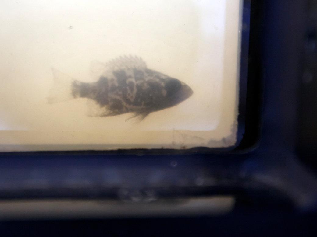
2013: Heavy spring rains caused severe flooding. The Grand River crested at 21.85 feet in downtown Grand Rapids on the 22nd, with fish being photographed from the submerged windows of buildings along the river.
April 22
1976: A tornado damaged several homes northeast of Burlington in Calhoun County.
Weather History for SE Michigan
April 16
On April 16th, 2018 Flint exceeded its all-time record snowfall of 83.9″ set in the winter of 2013-2014. A light snow accumulation of 0.2″ put the site at 84.1″ for the season. It would not be the final snow of the year.
Also on April 16, 1992, Wayne County was hit by an F2 tornado at 4:03PM.
April 17
On April 17, 1963, Monroe County was hit hard by an F3 tornado at 6:20PM that injured 1 person and caused approximately $250,000 in property damage.
April 18
On April 18, 1975, 2.69 inches of precipitation fell in Flint. This is the maximum precipitation record for the month of April in Flint.
April 19
On April 19, 1953, the temperature in Flint never rose above 35 degrees. This temperature was a record temperature, in that it was the lowest maximum temperature for that day. The next day, the record lowest maximum temperature for Flint was 34 degrees.
April 20
On April 20, 2000, 3.58 inches of precipitation fell in Detroit. This is the maximum daily precipitation record for the month of April and the sixth heaviest all-time daily rainfall in Detroit.
April 21
On April 21, 1976, an F2 tornado moved through Shiawassee County at 3:35PM. This tornado was one of the most damaging tornadoes in Shiawassee County since 1950 and caused 1 injury and over $500,000 in damage.
April 22
On April 22, 1875, Detroit had a record low temperature 20 degrees. The day before, on the 21st, Detroit had another record low of 21 degrees.
Forecast Discussion
- Showers and thunderstorms this afternoon and evening -

Elevated instability will increase this aftn/eve north of a warm
front. As a result sct showers/convection will develop in this
time frame as suggested by 00Z HREF guidance as h8 li/s fall to -2
to -4 with around 500-750 j/kg of elevated cape. Svr wx is not
expected but some swaths of around one to two inches of rain are
likely mainly near to north of I-96 as suggested by the HREF 24
hr qpf LPMM product.

- Another chance of thunderstorms Thursday afternoon/eve -

Sct sfc based convection will develop Thursday afternoon/eve in
the warm sector out ahead of the approaching cold front. Deep
layer shear is sufficient for some stronger convection and cold
frontal timing is conducive for that as well. However svr wx
potential is mitigated significantly by limited instability. All
things considered we are not expecting severe wx given what the
HREF and CAMs are depicting and rather meager instability.

- Cool and unsettled wx this weekend -

A sharp negatively tilted upper level low pressure system will
bring cool and unsettled wx this weekend into early next week.
Thermal profiles will cool sufficiently enough for snow to mix in
with rain showers through the weekend.

There may even be some light snow accumulations on the order of
an inch or less late Saturday through Sunday where p-type falls as
predominantly snow. Temps really will not begin to moderate again
until Tuesday by which time the upper low should lift further
north to James Bay and away from our region.

&&
High tenps in the 40’s this coming weekend we are definitely heading into a cool pattern who would of thought??? INDY
Nice try. It’s been a super warm April LOL
He said “heading into” he was never talking about the month as a whole. Nice try.
Yeahh my local weather bug shows 40’s for my hood this weekend thats definitely cold for the end of April standers if you ask me … Most will agree with INDY …
Rock on and keep the facts coming!
We have been in an overall cool pattern since March and the CPC shows no sign of any let up! Facts are facts!
Now the CPC has below normal temps at least through mid May! Wow just wow, WOW!!!!! Keep the cool weather rolling!
WOOD now has 3 nights with freezing temps starting this weekend and snow chances on Saturday! Clearly the cool Pattern continues!
WOOD now has 72 degrees for tomorrow and 66 degrees for next Thursday. It seems the more consistent warm air is trying to settle in.
Lansing is a whopping +7.8 degrees above average for April so far after +1.0 degrees above average in March.
It’s been an incredibly warm start to the spring/summer season.
Going to have to mow the grass tonight. Earliest date I can remember.
Another big cold front is coming through on Friday and then more freezing temps! The cold just keeps rocking and rocking!!!
Very cold this morning with freezing temps! Wow!
There will be a warm front moving thru today and with that there is a chance of some rain and thunder. Tomorrow there should be a brief warm up into maybe the upper 70’s before another big cool down for the end of the week and the start of next week and there is a chance of rain and yes snow for the week end.
Slim
The official H/L yesterday at Grand Rapids was 47/31 there was a trace of snow fall and the day started with a trace of snow on the ground. There was 42% of possible sunshine. The overnight low here in MBY was 29. The current temperature is 31 with cloudy skies.
Slim
For today the average H/L is 59/39 the record high of 82 was set in 1985 the record low of 19 was set way back in 1897. The record snow fall amount of 1.0” fell in 1953. Snow fall in now becoming rather rare. There has only been 4 years with measurable snow fall on this date and only 10 years with a trace or more
Slim
We didn’t get much precip yesterday morning, so I took advantage of it and mowed my lawn. That first cut is oddly satisfying. I did a bit of work on the flower beds too. The trees are really popping now and it’s becoming greener by the day. I really like this time of year.
Have a great Hump Day friends, and make someone smile. 🙂
I have not cut mine yet but I hope to be able to cut it some time this week. Once the trees start to green up it is hard to stop it. It has more to do with the ground temperatures than air temperatures.
But with the green up there will be frost and freeze warnings over the weekend and next week
Slim