
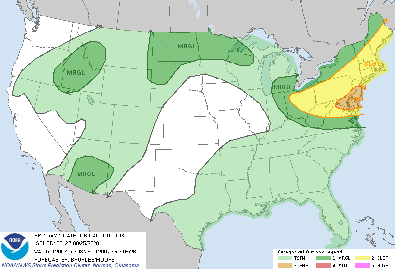
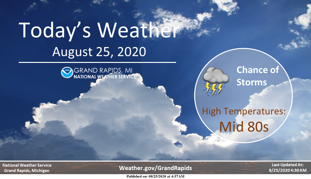
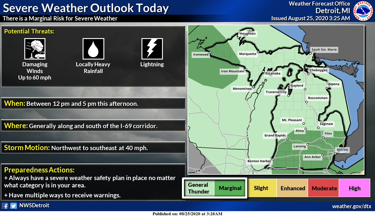
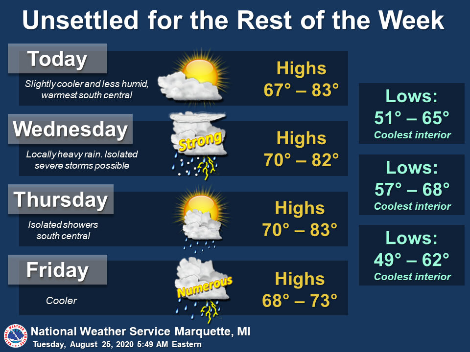
We have an area of rain and storms moving S.E. out of Wisconsin across the lake this morning. Should it all hold together SW Michigan should see a wet period through the morning hours. The SPC has southern Michigan in the marginal outlook area for severe weather for today.
Point forecasts for SW Michigan are trying to show around half an inch of rain for today, less around the Grand Rapid and Lansing areas. Another area of rain will try to move through tonight.
[columns] [span6]
[/span6][span6]
[/span6][/columns]
[columns] [span6]
[/span6][span6]
[/span6][/columns]
Forecast Discussion: South
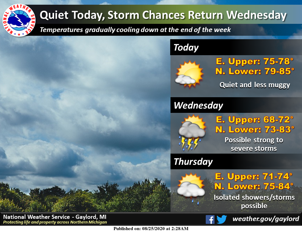
- Risk for Severe Weather and Heavy Rain this week

Early this morning the upstream storms have been severe in WI.
There is somewhat of a trend for the convection...in particular
the northern end to show a temporary weakening trend. The latest
SPC Meso Analysis page does show the MU CAPE dropping off over the
past couple of hours. Still the effective deep layer shear is
elevated throughout the region...which could support continued
organized convection. However based on the radar trends and the
latest HRRR suggesting less of a risk for severe storms moving
into MI...it appears any risk for severe weather should be
limited. DCAPE is spiked here in the CWA so if the storms
move...there could be some gusty winds...especially to the
southwest of a Muskegon to Grand Rapids to Lansing line.

The HRRR shows continued redevelopment of a narrow line of storms
through the heart of the CWA into the afternoon. At this time we
will feature some scattered storms into the afternoon.

The stalled frontal zone from Central WI into Southern MI lifts
north as a warm front tonight into Wednesday. Given the stronger
instability and deep layer shear around...and elevated potential
for organized convection is suggested. The storms could train for
a few hours which could raise the risk for excessive rain. By late
afternoon or evening...the axis of higher PWAT values is shown to
go north of the CWA.

In response to a mid level wave dropping in from the
northwest...a low level jet develops and strengthens along the
frontal zone into Wednesday night. At this time it appears this
activity will be focused north of the CWA...but that will need to
be monitored closely. Such a setup would enhance the severe
weather and heavy rain risk considerably.

On Thursday as the wave pulls off to the east...the frontal zone
will slip back into Central and perhaps Southern Lower MI.
Meanwhile a plume of tropical moisture will be lifting up the MS
Valley. The rainfall in these showers and storms will likely
become more efficient with time. Synoptic forcing will be lacking
though so we will keep the rain risk at scattered.

Concern for heavy rain and possibly severe weather is increasing
for Friday. A complicated upper flow patten is shown to exist but
ultimately evolves into a negatively tilted wave over the Great
Lakes Region. Given the anomalous moisture that will be in place
and synoptic forcing forecasted...a heavy rain event is looking
more likely with time. With a low level jet nosing in and
favorable deep layer shear some severe weather is looking possible
as well.

- Potential for hot temperatures mid week

With the warm front lifting north of the CWA on Wednesday...90s
are looking increasingly likely. We had some 90s around on Monday.
The new High Res Euro shows even warmer 925 mb temps for Wed. This
would translate into even warm High Temps. The southern half of
the CWA stays in the low level thermal ridge on Thursday so the
highest temperatures are forecasted down there. However as with
any convective event and slow moving fronts...the surface front
could end up being further south...limiting the potential for hot
temperatures.

- Cool down this weekend

On the backside of the departing wave Friday...a much cooler
airmass moves in for the weekend. Temps at 925 mb drop down to
around 10 to 12 deg C Saturday night. This actually is cold enough
for lake effect clouds and perhaps some showers. Below normal
temperatures will be forecasted for Saturday and Sunday.
Not much in the way of rain. Just 0.03″ of rain fall here. And the current temperature is 74.
Slim
Currently 72* degrees out at thee YARDofBRICKS NE of GR makes yesterdays 90* degrees feel great ….INDY
Rain…cute theory…
Here is an interesting tweet from Dr Juday Cohen:Withstanding that recent GFS forecasts have been unstable, GFS predicts that strong ridging in the Gulf of Alaska will force downstream troughing across much of North America that could potentially bring an early fall feeling from Alaska thru much of Canada & into the Eastern US.
Yes MV seeing that next week already temps only in the low 70’s that’s greatttt …With La Nina setting in this Winter above average snowfall??? Stay tuned ….INDY …
I will do a little history on La Nina winters sometime before the start of winter.
Slim
Things are are getting somewhat dry here as there has been officially 0.03″ of rain in the last 2 weeks and just 0.43″ is the last 21 days. The lawns that have not been watered are now turning brown. With some storms to the west and northwest it it now cloudy and 75 here with a DP of 70. It looks like the official low at GRR was 73. Here at my house it was 71. IF that 73 holds until midnight it will set a new record at Grand Rapids for the warmest minimum for August 25. The record… Read more »
Wow another record warm temp? Love it!
Well looks like the clouds will keep the temps down today as usual no need to head to the beach stay around the house have a sprite or two great Scotty loving the 70’s Friday this short lived heat wave if that’s what you want to call it is on its way out already shuu lol..Have a good Tuesday….INDY
Phew hit 91 yesterday with more 90’s upcoming! August is now warmer than average.