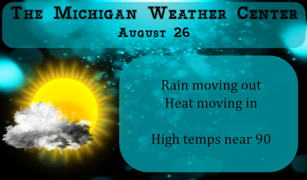
We managed a mere .10 of an inch of rain yesterday which brings us to 2.03 inches for August. There is a large area of rain moving through the eastern half of the state this morning from the Straits down to Detroit. Nothing for SW Michigan.
We have an Air Quality Alert for Muskegon, Ottawa, Kent, Allegan, and Van Buren counties today. Heat indices will be in the upper 90s.
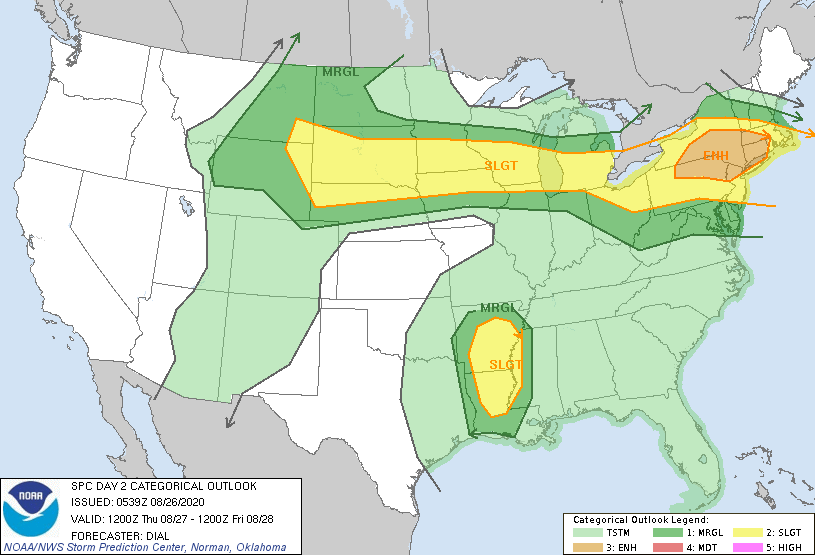
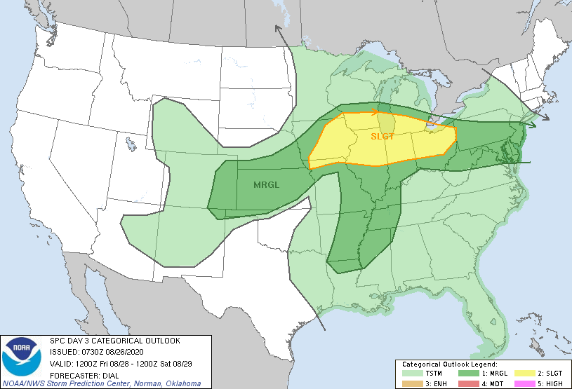
Looking ahead we are placed in the slight risk are for storms late tomorrow through Friday:
[columns] [span6]
[/span6][span6]
[/span6][/columns]
Forecast Discussion
- Strong early morning storms

Elevated early morning storms were developing north of a warm
front from near Ludington southeast to near Lansing. These storms
were taping MU CAPE values of 1500 to 2000 J/KG. In addition
Effective Deep Layer Shear was running 35 to 45 knots...which is
helping to keep the storms going. An isolated severe storm will be
possible early this morning based on these parameters. The warm
front lifts steadily northeast through the morning so the main
action over the next few hours will be for the area to the
northeast of a Ludington to Lansing. After the front goes north
of the CWA...little in the way of a focus for additional
convection will exist.


- Risk for severe weather and heavy rain Thu into Fri Night

While a lull in the storms may exist for a good part of
Thursday...overnight Thursday into Friday Night is shaping up to
be a rather active pattern. A digging upper wave moves in
supporting synoptic lift. An associated low level jet pulls in
from the southwest. Meanwhile the tropical moisture gets drawn
into the whole frontal zone over the Great Lakes Region. Thus
numerous showers and thunderstorms will be developing. The
rainfall will become more efficient with time and could end up
being excessive. In addition Friday afternoon and evening could
see an increased potential for severe weather as this is when the
low level jet and instability could work together enhancing the
risk.

- Cool down for the weekend

Enough cold air moves down over the weekend to support clouds and
cooler temperatures. We will need to monitor the precipitation
potential as lake moisture could eventually lead to some. Temps at
925 mb drop to 10 to 15 deg C by Sunday morning.
Weather History
August 23
2002: Several inches of rain in less than three hours caused flash flooding in Kalamazoo, where two homes and two businesses sustained extensive damage. Waldo Stadium, on the campus of Western Michigan University, also had major flooding. At one point, three feet of standing water covered the entire football field. The flooding caused an estimated 200,000 dollars in damage.
2007: Severe weather strikes Lower Michigan with large hail and damaging winds. Some of the worst damage is across Montcalm County where thousands of trees are downed by a tornado and downburst combination that produced estimated wind speeds up to 100 mph.
August 24
1947: The second long heat wave of the month comes to a close with record highs of 98 degrees at Grand Rapids and 96 degrees at Muskegon, contributing to the warmest August on record across West Michigan.
2006: Up to baseball-sized hail fell from a severe storm at Grand Junction in Van Buren County.
2007: Tornadoes strike Lower Michigan, with the worst damage near Potterville in Eaton County. Five people are injured and 15 homes are destroyed by a tornado with peak winds estimated at 140 mph. A weaker tornado hit southeast of Lansing but damage was limited to trees falling on mobile homes.
August 25
1910: A tornado injured four people near Scottville in Mason County. The tornado destroyed a cement block building, hurling the roof a half mile. Several other buildings were unroofed.
1940: A stalled cold front brings clouds and very cool high temperatures. At Muskegon the high was only 56 degrees and Lansing was 57, both records for the coldest maximum temperatures for the month of August. The high of 60 degrees at Grand Rapids is only one degree higher than the record of 59 degrees set on August 26, 1987.
2004: A strong downburst tore the roof off a section of the Maple Valley High School in Eaton County. The same storm produced a weak tornado minutes later that took the tin roof off a house in Vermontville.
August 26
2000: Heavy rain and high winds produce scattered damage and some flooding. The roof of a bowling alley near Jackson was damaged by an apparent microburst. Roads were closed due to flooding across southern Kalamazoo County.
August 27
1948: A late season heat wave with eight straight days in the 90s at Grand Rapids is underway. Record highs are set at Lansing with 98 degrees, Grand Rapids with 95 and Muskegon with 91.
1977: Only two days after setting a record low of 43 degrees, the low temperature at Muskegon is a balmy 74 degrees, a record warm low temperature for the date.
2004: A weak tornado struck near Sherman City in Isabella County. A mobile home was slightly damaged but no one was injured.
August 28
1982: A strong cold front pushes through and temperatures tumble to 36 degrees at Lansing, setting a record low for the date.
1986: There is an autumnal chill as morning lows fall to a record low of 41 at Grand Rapids and to 36 degrees at Lansing, tying the record low set only four years before.
August 29
1863: A hard freeze ends the growing season at many interior locations. Lansing falls to 26 degrees, the coldest ever recorded in August there.
1982: Cool air from Canada continues pouring in, with a record low of 38 degrees at Muskegon and 41 degrees at Grand Rapids.
Here is an interesting tweet from Dr. Judah Cohen:
Withstanding that recent GFS forecasts have been unstable, GFS predicts that strong ridging in the Gulf of Alaska will force downstream troughing across much of North America that could potentially bring an early fall feeling from Alaska thru much of Canada & into the Eastern US.
Currently 80 degrees after midnight. Where is this “temps fall as fast as the sun”? Crazy temp for this time of the night!
Power went out here shortly before 4 PM today. It didn’t take long for the temp in the hous to clim above 80 degrees. It came back on around 6:30 which was earlier then they had been saying. The A/c feels great!
Ours went out for about a minute but then came back on. I checked the consumers outage map and East of us to Hudsonville was out. Bad day to lose the AC!
Currently 82* degrees out at thee YARDofBRICKS NE of GR isn’t it getting great getting dark early temps fall as fast as the sun does now ohhh darn…Cold front is close again to put out the 90’s probably longer then a month this time around I’m thinking……..Heat Scotty lol…INDY
Currently 85* degrees out at thee YARDofBRICKS NE of GR not even close to once thought 94* degrees today and a heat index in the 100’s today must be hard to forcast high temps in late August I guess lol…INDY
91 with a heat index of 98 is not even close? I think you need to rethink that post.
https://forecast.weather.gov/product.php?site=grr&product=cli&issuedby=grr
93 in Kalamazoo. Long ways from 94? 🤦♂️
https://w1.weather.gov/data/obhistory/KAZO.html
The heat has gotten to Indy! LOL
Heat index approaching 100 degrees! And hotter tomorrow? Wow!
It is now officially 90 at Grand Rapids. This is just the 11th time it has reached 90 or better on any August 26th at Grand Rapids.
Slim
Yeah it feels just awful out. Heat index is now 97 here. 🤮
Laura is now the strongest August hurricane in the Gulf since Katrina in 2005. Wow!
currently 72* degrees out at thee YARDofBRICKS NE of GR some locals saying 94* degrees and heat index into to the 100’s today have they falling off there rockers again?? Well the sun finally come out that may help lol…INDY
Ah the usual Indy doubting post. For the record, it’s a steamy 88 degrees at GR at 3pm. Phew!
Ohh I’m glad we finally found out where you post from interesting….INDY
Hurricane Laura is rapidly intensifying over the central Gulf of Mexico and is now a major Category 3 hurricane. It will reach the Gulf Coast near the Texas/Louisiana border tonight as a possible Category 4 hurricane, producing significant damage and dangerous storm surge. Current Laura ForecastAs of 7 a.m. CDT, Hurricane Laura was located near 26.4 N, 91.4 W, or about 280 miles south-southeast of Lake Charles, La., and 290 miles southeast of Galveston, Texas. Laura is a Category 3 hurricane with winds of 115 mph. The system is moving to the northwest at 15 mph with a minimum central… Read more »
Laura is exploding right now. I feel for the folks down there. 😔
It kind of reminds me of Hurricane Charley in 2004 a small but deeping storm.
Slim
We didn’t get one drop of rain here.
Yesterdays official low of 72 at Grand Rapids tied 1948 for the record warmest minimum for August 25. Here at my house I recorded 0.16″ of rain yesterday that is more then the airport where only 0.04″ fell. At this time it is 70 with a DP of 67 both here and at the airport with cloudy skies and a NE wind.
Slim
Heat Index near 100 degrees the next 2 days! Wow! I thought we were done with the heat according to some on here?
Only a few drops of rain here yesterday, not even enough to register anything on the gauge. Looks like the record was tied or set yesterday for the warmest minimum temp ever. What a long stretch of above average we’ve been in. 7 of the last 9 months I believe? And yet another action day today for the heat. Feels like Fall?
It is looking ever more likely that 2020 will be GR’s 4th straight warm year. I love it!
Here at my house I recorded a total of 0.16″ of rain yesterday. Around 1:30 AM there was a shower with some lightning. So it is still dry and still not many thunderstorms. That seems to be the trend we have been in for several years now.
Slim