Mixed precipitation will impact the region near and north of I-96 Friday night into Saturday night with areas of freezing rain and snow. South of I-96, rain is expected.
...WINTER STORM WATCH IN EFFECT FROM LATE TONIGHT THROUGH
SATURDAY AFTERNOON...

* WHAT...Snow. Some light freezing rain possible as well. Total
  snow accumulations of greater than 6 inches possible. Ice
  accumulations of around one tenth of an inch possible. Winds
  could gust as high as 40 mph.

* WHERE...Mason, Lake and Oceana counties.

* WHEN...From late tonight through Saturday afternoon.

* IMPACTS...Plan on slippery road conditions.
...WINTER STORM WATCH NOW IN EFFECT FROM SATURDAY MORNING THROUGH
LATE SATURDAY NIGHT...
Cheboygan-Presque Isle-Otsego-Montmorency-Alpena-Crawford-Oscoda-
Roscommon-
* WHAT...Heavy snow possible. Total snow accumulations of 5 to 10
  inches possible. Winds could gust as high as 40 mph.
U.S.A and Global Events for March 24th:
1912: Residents of Kansas City began to dig out from a storm that produced 25 inches of snow in 24 hours. The snowfall total was nearly twice that of any other storm of modern record in Kansas City before or since that time. A record 40 inches of snow fell during March that year, and the total for the winter season of 67 inches was also a record. By late February of that year, Kansas City had received just six inches of snow. Olathe, Kansas received 37 inches of snow in the snowstorm, establishing a single storm record for the state of Kansas. (23rd-24th)
1929: St. Louis, Missouri soared to 92 degrees; their all-time record high for March.
1975: “The Governor’s Tornado” hop-scotched a 13-mile path across the western part of Atlanta, GA during the early morning hours, causing considerable damage to the Governor’s mansion. Hundreds of expensive homes, businesses and apartment complexes were damaged. Total losses were estimated at $56 million. Three people lost their lives, and the F3 tornado injured another 152.
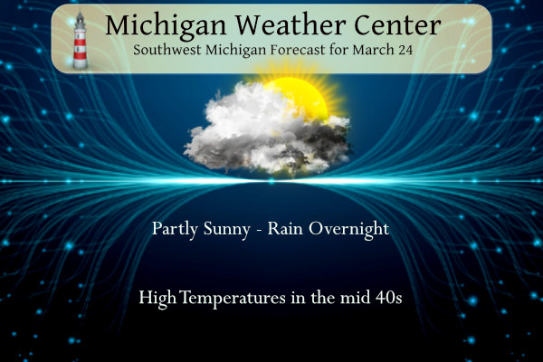
Grand Rapids Forecast
3 24 grrLansing Forecast
3 24 lanKalamazoo Forecast
3 24 kzoForecast Discussion
-- Winter Weather Tonight into Saturday --

Bottom line up front...we are adding a few counties into a Winter
Storm Watch up against APX`s area. Mason, Oceana and Lake Counties
will be now be in a Winter Storm Watch for late tonight and much
of Saturday.

Upper wave that brings a mix of precipitation into the area
tonight is currently in NM/TX. The upper wave races our direction
today on a 100-120 knot upper jet. The surface low deepens from
about 1000mb this afternoon/evening to below 990mb by 12z on
Saturday. The track of the low through Lower Michigan is still a
bit uncertain, but the ECMWF and GFS operational runs have trended
a bit towards each other. Leaning on the GEFS MSLP output we feel
the low will track from north central/northeast IN into south
central Lower Michigan and further northeast into Lake Huron. We
feel the area that stands the best chance at accumulations
reaching warning criteria possibly will be our far northwest CWA
towards Ludington, Hart and Baldwin. There is a chance especially
if a bit further east track verifies that warning snows may be
possible as well across the rest of the U.S. 10 corridor towards
Evart and Clare as well. Not as confident in that occurring so
held off on those areas. A wintry mix of precipitation is possible
between I-96 and U.S. 10 as a nose of warmer air aloft overspread
near to possibly just below freezing surface temperatures and
dynamic cooling of the profile and wet bulb affects bring freezing
rain into the picture. We will likely be issuing winter weather
advisories and possibly warnings on the day shift today in
coordination with neighboring offices. Snowfall totals in the
northwest CWA may approach or exceed 8 inches. 6+ inch totals
seem possible across the remainder of the U.S. 10 corridor. Cannot
rule out a tenth of so of ice accumulation before warm air
advection changes it over to rain.

-- Additional chances for precipitation through the period --

A weak wave sliding through the area early in the week Monday into
Monday night will be a light mix of precipitation. The
precipitation is not very substantial and we therefore only have
20 pct pops in the forecast at this point.

Later in the week from Wednesday into Friday, better chances for
precipitation exists as first a lead wave moves through mid week
followed by a stronger system for weeks end.
Great news! The latest weather maps look great for warmer weather as we head into April! I love short warm winters!! Incredible! Let’s get it rocking baby!
Saturday
Rain showers and sleet, possibly mixed with snow showers before 4pm, then a chance of rain showers between 4pm and 5pm, then a chance of rain and snow showers after 5pm. The sleet could be heavy at times. High near 38. Windy, with an east northeast wind 25 to 30 mph becoming north 18 to 23 mph in the afternoon. Winds could gust as high as 44 mph. Chance of precipitation is 100%. New snow and sleet accumulation of around an inch possible.
Let’s go snowshoeing sounds beautiful!
Hey everybody the pivotalweather maps say 24 inches of snow for July 4th!! I’m gonna drive to Antarctica to go skiing!!
Derp Derp, you want to put money on that 18 inches of snow you’re predicting between now and then for here! What a frigging joke of a garbage map! Your prediction map showed that Detroit was supposed to have 28 inches of snow by now? LOLOLOLLOL!!! Your maps are as fake as the Libtard news you listen to!
Lows in the 20’s most of next week! The cool pattern shows no sign of any let up! Wow to the wow! WOW!
No snow for the next 2 weeks, the dry pattern is here to stay! LGB!!
No WWA here, winter is deader than dead!! Suck off Rocky!! As dead as the BS case against Trump in Manhattan! Lol!!
Breaking>>>>the NWS has placed Muskegon, Newaygo and Montcalm counties in another WWA! The RDB says kent should be in one also! The northern 1/2 of Kent may see up to 1/4 inch of freezing rain and 1 to 2 inches of sleet/snow! Get prepared now!!!
The latest GRS is looking promising! Is winter dead yet?
https://www.pivotalweather.com/model.php?p=snku_acc-imp&rh=2023032412&fh=120
I love long snowy winters, just like the one we are having as we speak! Incredible snow totals this year!
Bot the warm weather nuts are even more delusional as Spring rolls on! Incredible!
Another warm month and a weak, very warm winter. It’s been fantastic!
Snow chances well into April! Love long winters!!!
https://www.pivotalweather.com/model.php?p=snku_acc-imp&rh=2023032406&fh=384
As a side note, the past month really has put a huge dent into the drought in the thumb. https://droughtmonitor.unl.edu/CurrentMap/StateDroughtMonitor.aspx?MI
Excellent!
The cool, snowy pattern continues! Wow the wow, WOW! Rock n roll will never die!
WOOD: Little to no accumulation for GR and any snow will melt quickly on warm ground
Boy, the winter nuts are going crazy this morning for nothing LOL
Well we are a week away from April and its only 34 degrees outside now thats crazy if you ask me!! The 60 degree drought continues!! InDay!!
The hefty accumulations just keep hitting the state!
Definitely a warm weather Spring drought! Who would have thought?
Winter storm watches out ??? Great balls of fire …INDay!!
What a snowy and stormy winter! One for the record books!!!
Let the good times roll!
The storm track looks to be another one with a large snow gradient possible over a short distance. The current warnings are saying 5-10”, just 30-50 miles north from areas expecting 1-3. It should be interesting to see Where that temperature and wet heavy snow ultimately sets up.
Get ready – another WWA is coming! One of the wildest and snowiest winter ever! Incredible!
It has been yet another month with above average snowfall and our cool pattern continues with more snow chances! What a snowy and long winter! Wow to the wow, WOW!
Random fact I noticed: the average high temperature in Grand Rapids throughout March almost exactly matches the day’s sun angle. For example, today the angle is 48.6 degrees, which is the same as the average temp of 48
More winter storm watches In MI. A few in the NWS GR coverage area. One of the best winters ever continues to roll on! Let the good times roll!
The weather has been horrific in California (tornado in LA, really??). On the bright side, the drought has subsided dramatically. Considering that nearly one-third of all US agriculture comes from California’s central valley, this is good news.
https://www.cnn.com/2023/03/23/us/atmospheric-river-winter-california-drought-climate/index.html
It’s been amazing how long that cold and rainy pattern has held on in California. Especially without a strong el nino, which is when you’d typically see this pattern.
As Rocky would say- wow to the WOW!
Not to mention the FEET of snow. Lake Tahoe has received more than 500 inches.
It’s been yet another warm month. So glad all the snow is going north of us. By next Thursday, we get back into the 50’s for good it looks like. Then, we start our march into summer!
March into summer?? Grasping…. ha ha INDay
Yes, he is definitely desperate and pathetic! No 60’s in sight and barely 50 degrees in sight! We are entrenched in a cool pattern and the CPC says it will stay that way! Wow!
I want to know how the NWS can go from a forecast of “mostly sunny”, to “mostly cloudy” in a 24 hour forecast period? Hove we not improved on our ability to reach out 1 day predicts?
I expected clouds all day yesterday but the skies cleared out in the afternoon. Go figure.
I agree!
Is winter dead yet? What a joke! Heading into the last week of March and snow is still in the forecast! How incredible is that? What an incredible and long, snowy winter! Wow!!!
We are now down to the last week of March 2023. So far March has been a mild but somewhat snowy month. Grand Rapids, Muskegon and Lansing have been above average in both temperatures and snow fall. At Grand Rapids the official H/L yesterday was 48/36 there was no rain or snow fall and the sun was out 19% of the possible time. The overnight low here in MBY so far and the current temperature is 32. For today the average H/L is 48/29 the record high of 78 was set in 1910 and 1939 the record low of -3… Read more »
If you were awake around 10:30 11:00 last night the northern lights were showing across Michigan. I was able to see them here in Portland for my first time ever. I was so thrilled!
I am sorry that I missed that. The only time I seen the northern lights were up at Sault way back in the day.
Slim
I was able to see them! First time for me in Michigan! They were a little dim, since my view of the horizon is blocked by trees, but it was still awesome.