After a busy summer and fall, I for one am ready for a long winter’s nap. It is great being a retired person as I can look forward to such things and am not pressured to punch the clock at work. I have all the Christmas lights on the house and the 100 feet of rail fence running along the road. Ah, life is grand and I am blessed (with the exception of any snow removal which may have to be done this winter and I suspect it will be more than we have had the past few years with perhaps more lake effect than the past few years.)
We have 39.5° at 5 am this morning. Yesterday we had .24 of an inch of rain which is our total rainfall for the month. Our high temp was 60° and the low was 37°.
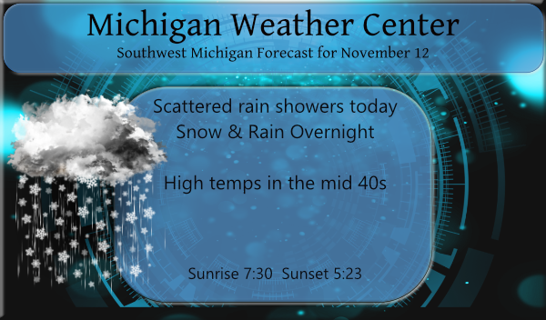
Lake effect rain showers will become more widespread through the morning. Rain and snow showers will continue off and on right on through the weekend. Some locations will see some light snow accumulations, especially at night, and on Sunday. The highest snowfall amounts would be along and west of 131.
Below are the descriptions of various winter precipitation:
Snow is small white ice crystals formed when supercooled cloud droplets freeze. Snow crystals can have different shapes usually dictated by the temperature at which they form.
Snow pellets, also called graupel, are white, opaque ice particles round or conical in shape. They form when supercooled water collects on ice crystals or snowflakes. They typically bounce when they fall on a hard surface and often break apart.
Snow grains are very small, white opaque particles of ice, more flattened and elongated than snow pellets. Snow grains can be thought of as the solid equivalent of drizzle, or as I like to call it, “snizzle”.
Ice pellets, or sleet, are small balls of ice. They form from the freezing of raindrops or the refreezing of melting snowflakes when falling through a below-freezing layer of air near the earth’s surface.
Freezing rain occurs when rain occurs and the surface temperature is below freezing. The raindrops become supercooled as they fall through the layer of cold air near the surface and freeze upon impact with surfaces below freezing.
Forecast Discussion
- Periods of rain and snow showers through Saturday night

A nice band of showers and storms by November standards occurred
west of U.S.-131 earlier this morning. These were the result of a
strong short wave moving through, and the upper cyclonic flow/cold
pool aloft pushing in over the relatively warm waters of Lake
Michigan.

A few additional showers will be possible this morning, but the
overall coverage and intensity of these showers will be limited as
we see short wave ridging building through. We do expect to see
showers blossom fairly well this afternoon downwind of Lake Michigan
as another strong wave embedded in the upper low complex will drive
toward the area. The forcing, combined with 850 mb-lake temperature
differences of almost 20C and inversion heights pushing 20k ft will
support additional lake effect.

The favored area will initially the NW portion of the area, toward
Ludington as the flow will be from the SW. Accumulations may be
tough to occur initially with sfc temps in the 40s and daylight
keeping some pcpn rain, and ground temps also in the 40s. The
favored area will then shift to the SW corner of the area for the
tonight period as the flow becomes more from the WNW. This actually
might be the best potential for some snow accumulations through
tonight with temps dropping and it being dark.

The shower activity will tend to diminish during the overnight hours
as the strong upper wave will push east of the area. A few rain and
snow showers will remain possible on Saturday and Saturday night,
but we do not expect them to be too organized with a lack of a
significant wave to drive them.

- Some snow accumulations likely on Sunday

The best chance for some potential widespread snow accumulations
still looks to be very late Saturday night into Sunday afternoon. We
will see another strong upper wave push toward the area. This will
support a somewhat compact, yet potent sfc low move near the
Southern MI/In/OH border.

We will remain on the cold side of the system, with plenty of warm
air aloft pushing into the colder air. In addition, we will be under
the deformation zone of the strong mid level wave. The model and
ensemble consensus seems to be pointing toward a general 1 to 3 inch
snow accumulation. Snow rates will help with the accumulation
potential a bit, even occurring during the daylight hours. The warm
ground will again limit accumulations from piling up too much. What
is interesting about this system is the heaviest amounts could end
up being over the SE portion of our area with potential lake
enhancement from Lake Huron with a low level flow from the NE
expected. The snow will wind down late Sunday afternoon-early Sunday
evening as the system pulls away.

- Additional small chances of precipitation next week

We will see a less active/unsettled weather pattern then take shape
for the area after the Sunday system. Some light lake effect may
linger into Monday, but this will diminish as high pressure builds
in.

We will see the upper jet end up north of the area from Monday and
beyond. This will keep the deep cold and unstable air out of the
area. A push of warmer air aloft will occur late Monday night and
into Tuesday. This could generate some light precipitation,
especially up north. We will see a brief warm up, before a cold
front moves in by early Wednesday. This cold front does not look to
have much moisture with it as it moves through with a lack of a good
Gulf feed. It will become more active east of the area. Much cooler
temperatures will return by the end of the period next Thursday. The
core of the deep cold air and cyclonic flow will stay north,
limiting lake effect chances.
Well…it is Winter, in the Southern Arctic. Not necessarily “headlines”
Nice long range snow map! Bring it!
https://www.instantweathermaps.com/GFS-php/conussfc.php?run=2021111218&time=PER&var=ASNOWI&hour=384
Roads are covered here, at least in my neighborhood. Just took my dog for a walk, he loves the snow
Fantastic!
Ground is covered with snow …InDY
Let it snow let it snow let it snow ….Indy
Pretty big snowflakes 30 minutes ago. The flakes look really nice next to the brown trees. Hopefully the snow sticks to the grass tonight… it seems like the roads are pretty warm and wet so not entirely sure if much will stick to the roads.
Let it snow ..INDY
What? Snow in mid November! Who would have thought?
Been getting on and off heavy rain, hail and some snow mixed in. It is not a nice day outside at this time. With this mix it is now 37.
Slim
Quite a few golfers out this morning but the course looks empty now.
Lots of very interesting looking cloud formations today.
Interesting weather this morning. Quite a bit of lightning, thunder, and heavy hail down bursts. The noise of it hitting the roof at work was deafening when it was really coming down. Stripped a lot of leaves off the trees, but still a lot of good color around town yet.
I thought I seen a flash of lightning. Been getting a mix of rain, hail and snow here off and on.
Slim
Here at my house I recorded a total of 0.24″ of rain yesterday and overnight. With some clearing it dropped down to 37 here and 36 at GRR before the clouds moved back in. At this time it is mostly cloudy and 39 here. Yesterdays wind did a number on the leaves on the trees in my area and while the Oak still have a lot of leaves on them the other trees are either bare or still have a few clinging to them.
Slim
Getting snow in the middle of November incredible!!!….InDY
Check it out! Let it snow!
https://www.instantweathermaps.com/GFS-php/conussfc.php?run=2021111206&time=PER&var=ASNOWI&hour=384
Loving it who knew??? InDY
Wow, it is great to see the word snow mentioned so often in the forecast discussion! Incredible!