Happy Veterans Day and thanks to all who have served this country with valor, sacrifice and honor.
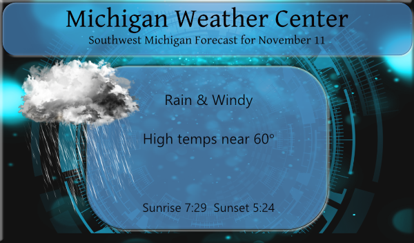
We have 51° at 5:30 this morning under cloudy skies. Yesterday we had a high of 56° and a low of 26°.
Rain will overspread the region from west to east between late morning and afternoon, tapering to showers by evening. Strong SE winds will gust to around 40 mph (higher near lakeshore), then veer to SW by evening. Colder air will arrive for Thursday night and beyond.
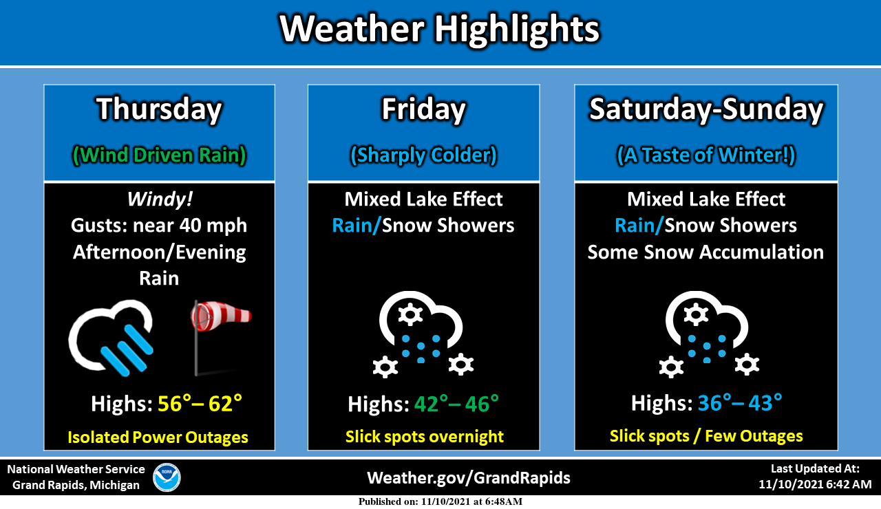
We have a strong fall storm preparing to move into Michigan this morning so it will not be the greatest of days for outside activities for Veterans Day. Winds will ramp and peak today with gusts around 40 mph expected. A few power outages are possible. Wind-driven rain is forecast Thursday afternoon and evening. Colder air will sweep into the area for Friday through the weekend. A mix of rain and snow showers are likely from Friday through Sunday. Some light accumulations of snow will occur between Friday afternoon and Sunday, especially on grassy areas. Heavier wet snow at times falling on trees that still have leaves could result in a few power outages this weekend. Slick spots are possible on roadways especially overnight this weekend.
Forecast Discussion
- Wind driven rain today

A band of rain associated with the cold front will sweep through
the area between noon and 700pm today. An enhanced narrow cold
frontal rain band will be embedded within this area of rain and
move through between 200pm and 600pm. The depth of the low in the
arrowhead of Minnesota will drop to 986mb per the GFS this
evening. Given a low of that depth we will see stronger winds all
day due to the gradient, but the strongest winds will likely come
from gusts associated with the narrow cold frontal rain band. The
rain band is best seen in the HRRR composite reflectivity
guidance. Cannot rule out a rumble of thunder within the line, but
850mb LI`s are positive and MUCAPE values are less than 150 j/kg.

- Long period of lake effect rain/snow showers starts late tonight

Still on track for a long period of lake effect rain and snow
showers which starts tonight as the lake become activated. Lake
temperatures are around +12C, so once air temperatures at 850mb
reach -1C, precipitation production should begin. Lake generated
MUCAPE values tonight are quite impressive on the order of
500-1000 j/kg. So we will certainly see convective elements
within the lake precipitation bands. Not out of the realm of
possibilities to see some embedded thunder tonight with the lake
precipitation. Deep moisture remains in place from tonight through
the weekend along with increasing instability. Delta T`s over the
weekend will be in the upper teens C. Thinking we are looking at
both rain and snow showers given a warm lake and wet bulb zero
heights that rise to around 2000ft at times. As we head into
Saturday night and Sunday though the precipitation will
predominately be snow. Accumulations of snow are likely across
Western Lower Michigan along and west of Highway 131.

- Two periods of enhanced potential for lake precipitation

There are two distinct periods of time where the non stop lake
generated precipitation will be enhanced. The first will be Friday
into Friday night and the second being Saturday night into Sunday.

As for Friday and Friday night...multiple stronger shortwaves will
be interacting with an unstable lake boundary layer. BUFKIT
overview profiles at MKG are fairly impressive with a cross hairs
signature and very deep moisture. Moisture extends to 20,000ft
with deep lift which are both associated with the main upper
trough pushing in. Enhanced bands of lake generated precipitation
can be expected. The bands will be transitory as the winds will be
shifting from SW to NW through this period. Expecting some wet
bursts of heavy snow that could lead to both slick roads for a
time and some isolated power outages (given some leaves on the
trees, especially towards the lakeshore).

The second period of time could also be impressive as a clipper
system bringing synoptic precipitation interacts with an activated
lake boundary layer. These types of setup produce our most
impressive lake effect precipitation events. Its early season so
its a bit hard to tell how impactful this event will be, but we
expect additional bursts of lake enhanced snow and rain. Moisture
is very deep once again looking at the GFS overviews at Ludington.
Winds will be shifting once again from SW to NW this time.

Bottom line is we are going to see accumulating snow in lake snow
belts across the western half of our forecast area or near and
west of Highway 131. Some quick bursts of 2-4 inches of snow may
happen a couple to several times between Friday and Monday. Given
a warmer ground (44 degrees at 2 inches at GRR) we may mitigate
some of the road/travel problems. That said if it snow hard enough
which we think it will there will be short duration travel issues,
especially Saturday night into Sunday when we will be colder.

- Some uncertainty into mid next week in pattern evolution

There are some timing issues as we head into Tuesday and Wednesday
of next week. A zonal flow aloft will be in place with an trough
moving through the flow over the Northern Plains. The ECWMF is
quicker pushing a cold front into the Great Lakes during this
time. There is a brief warm up ahead of this system, so at this
point we are looking at some rain from Tuesday into Wednesday.
Jury is still out on the exact details with this system. We
increase our chances for rain to 30-40 percent on Wednesday.
Thunderstorm here tonight. Thunder is so loud it made me jump! It was raining pretty good but didn’t last long.
Also Happy Veterans Day to our great veterans!
We are now entering “late fall” where most leaves are off the trees and precipitation transitions between rain and snow. I’m hoping the precip stays mostly snow this weekend so we can get some accumulation, but we will see with the warmer afternoon temps.
Either way, looks like any snow we get will melt next week. But winter is getting closer!
67 degrees here and the wind is kicking!
For all of the warm weather fanatics out there that are still preaching and hoping for above normal temps in November! Forget about it and face reality! The pattern change is evolving as we speak! Get prepared now! Rock n roll will never die!
https://www.instantweathermaps.com/GFS-php/conussfc.php?run=2021111112&time=PER&var=ASNOWI&hour=384
The overnight low here at my house was a mild 47 and at this time it is 50 with cloudy skies. This weekend the set up looks good for lake effect. We shall see but to me it looks like the temperatures are a little too warm for any big time lake event snow. While there is a very good chance that we will see snow with the forecasted temperatures it would seem hard for a lot of snow accumulation. Anyway if the temperature were colder would have been in a good set up for a lot of lake effect… Read more »
A very special Thank You to all of our veterans!
Slim
All signs still point to a cold and snowy winter for MI! Get your snowblowers tuned up and ski passes purchased! It is going to be wild!
Thank you to ALL veterans! You rock!
There is an amazing four part series on PBS right now called American Veteran. Three episodes have been televised so far, but you can watch them on the PBS website. I highly recommend it. It has stirred up some significant emotions in me.
Thank You Veterans for your service to our country!! Thanks to their family and friends as well before, during, and after their service!
Finished getting Christmas lights up yesterday….now we will wait until after Thanksgiving to turn them on.
There is an amazing four part series on PBS right now called American Veteran. Three episodes have been televised so far, but you can watch them on the PBS website. I highly recommend it. It has stirred up some significant emotions in me.