We have a temp of 17° at 5:30 this morning, a bit cold for late March. Yesterday we had a high temp of 33° and a low of 17°, more like January than March.
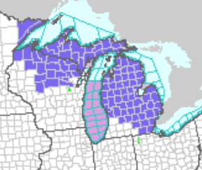
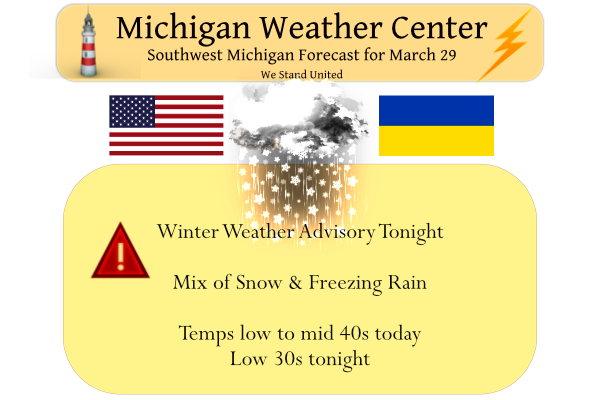
Here we go again – a bit late in March for these discouraging words from the NWS. Most of the state will be under a winter weather advisory tonight through tomorrow morning/afternoon depending on where you live in the state.
Mason-Lake-Osceola-Clare-Oceana-Newaygo-Mecosta-Isabella-Montcalm-
Gratiot-Clinton-
Including the cities of Ludington, Baldwin, Reed City, Clare,
Hart, Fremont, Big Rapids, Mount Pleasant, Greenville, Alma,
and St. Johns
402 AM EDT Tue Mar 29 2022

...WINTER WEATHER ADVISORY IN EFFECT FROM 10 PM THIS EVENING TO
NOON EDT WEDNESDAY...

* WHAT...Mixed precipitation including freezing rain expected. Total
  snow accumulations of up to one inch and ice accumulations of
  one tenth to two tenths of an inch.

* WHERE...Portions of central, south central and west central
  Michigan.

* WHEN...From 10 PM this evening to noon EDT Wednesday.

* IMPACTS...Plan on slippery road conditions. The hazardous
  conditions could impact the morning commute.

* ADDITIONAL DETAILS...Mixed precipitation in the form of ice
  pellets and freezing rain will develop late tonight. Peak
  intensity will occur overnight into Wednesday morning. Ice
  accumulations up to one to two tenths of a inch is possible.
  Slippery roads will be possible for the Wednesday morning
  commute.
Muskegon-Ottawa-Kent-Ionia-Barry-Eaton-Ingham-Jackson-
Including the cities of Muskegon, Grand Haven, Jenison,
Grand Rapids, Ionia, Hastings, Charlotte, Lansing, and Jackson
402 AM EDT Tue Mar 29 2022

...WINTER WEATHER ADVISORY IN EFFECT FROM 8 PM THIS EVENING TO
10 AM EDT WEDNESDAY...

* WHAT...Mixed precipitation including freezing rain expected.
  Total snow accumulations of up to one inch and ice accumulations
  of around one tenth of an inch.

* WHERE...Portions of south central, southwest and west central
  Michigan.

* WHEN...From 8 PM this evening to 10 AM EDT Wednesday.

* IMPACTS...Plan on slippery road conditions. The hazardous
  conditions could impact the morning commute.

* ADDITIONAL DETAILS...Mixed precipitation in the form of ice
  pellets and freezing rain will develop late tonight. Peak
  intensity will occur overnight into Wednesday morning. Ice
  accumulations up to trace to one tenth of a inch is possible.
  Slippery roads will be possible for the Wednesday morning
  commute.
Antrim-Otsego-Crawford-Oscoda-Ogemaw-Iosco-Arenac-Charlevoix-
Including the cities of Mancelona, Gaylord, Grayling, Mio,
West Branch, Tawas City, Standish, and Charlevoix
403 AM EDT Tue Mar 29 2022

...WINTER WEATHER ADVISORY IN EFFECT FROM 1 AM TO 2 PM EDT
WEDNESDAY...

* WHAT...Mixed precipitation expected. Total snow accumulations
  of up to one inch and ice accumulations of one tenth to two
  tenths of an inch. Winds gusting as high as 35 mph.

* WHERE...Portions of Northern Lower Michigan.

* WHEN...From 1 AM to 2 PM EDT Wednesday.

* IMPACTS...Plan on slippery road conditions. The hazardous
  conditions could impact the morning commute.
Leelanau-Benzie-Grand Traverse-Kalkaska-Manistee-Wexford-
Missaukee-Roscommon-Gladwin-
Including the cities of Northport, Frankfort, Traverse City,
Kalkaska, Manistee, Cadillac, Lake City, Houghton Lake,
and Gladwin
403 AM EDT Tue Mar 29 2022

...WINTER WEATHER ADVISORY IN EFFECT FROM 11 PM THIS EVENING TO
NOON EDT WEDNESDAY...

* WHAT...Mixed precipitation expected. Total snow accumulations
  of up to one inch and ice accumulations of one tenth to two
  tenths of an inch. Winds gusting as high as 35 mph.

* WHERE...Portions of Northern Lower Michigan.

* WHEN...From 11 PM this evening to noon EDT Wednesday.

* IMPACTS...Plan on slippery road conditions. The hazardous
  conditions could impact the morning commute.
Midland-Bay-Saginaw-Shiawassee-Genesee-
Including the cities of Midland, Bay City, Saginaw, Owosso,
and Flint
402 AM EDT Tue Mar 29 2022

...WINTER WEATHER ADVISORY IN EFFECT FROM 10 PM THIS EVENING TO
NOON EDT WEDNESDAY...

* WHAT...Mixed precipitation expected. Total snow accumulations
  of up to one inch and ice accumulations of one tenth to two
  tenths of an inch.

* WHERE...Midland, Bay, Saginaw, Shiawassee and Genesee Counties.

* WHEN...From 10 PM this evening to noon EDT Wednesday.

* IMPACTS...Plan on slippery road conditions. The hazardous
  conditions could impact the morning commute.

* ADDITIONAL DETAILS...A burst of snow and sleet moves into the
  area west of I-75 by 10 PM and then spreads southwest to
  northeast across Flint and the Tri Cities. Snow and sleet change
  over to freezing rain quickly by midnight which then continues into
  Wednesday morning.
Huron-Tuscola-Sanilac-Lapeer-St. Clair-Macomb-
Including the cities of Bad Axe, Caro, Sandusky, Lapeer,
Port Huron, and Warren
402 AM EDT Tue Mar 29 2022

...WINTER WEATHER ADVISORY IN EFFECT FROM MIDNIGHT TONIGHT TO
NOON EDT WEDNESDAY...

* WHAT...Mixed precipitation expected. Total snow accumulations of
  up to one inch and ice accumulations of one tenth to two tenths
  of an inch.

* WHERE...Huron, Tuscola, Sanilac, Lapeer, St. Clair and Macomb
  Counties.

* WHEN...From midnight tonight to noon EDT Wednesday.

* IMPACTS...Plan on slippery road conditions. The hazardous
  conditions could impact the morning commute.

* ADDITIONAL DETAILS...A burst of snow and sleet moves into the
  area east of I-75 and north of M-59 by midnight and then spreads
  southwest to northeast across the I-69 corridor and Thumb
  region. Snow and sleet change over to freezing rain quickly not
  long after midnight which then continues into Wednesday
  morning.
Livingston-Oakland-Washtenaw-Wayne-Lenawee-Monroe-
Including the cities of Howell, Pontiac, Ann Arbor, Detroit,
Adrian, and Monroe
402 AM EDT Tue Mar 29 2022

...WINTER WEATHER ADVISORY IN EFFECT FROM 8 PM THIS EVENING TO
10 AM EDT WEDNESDAY...

* WHAT...Mixed precipitation expected. Total snow and sleet
  accumulations of up to one inch and ice accumulations around one
  tenth of an inch.

* WHERE...Livingston, Oakland, Washtenaw, Wayne, Lenawee and
  Monroe Counties.

* WHEN...From 8 PM this evening to 10 AM EDT Wednesday.

* IMPACTS...Plan on slippery road conditions. The hazardous
  conditions could impact the morning commute.

* ADDITIONAL DETAILS...A burst of snow and sleet moves into the
  area west of US-23 by 8 PM and then spreads southwest to
  northeast across metro Detroit and the northern suburbs. Snow
  and sleet change over to freezing rain quickly during the
  evening which then continues after midnight into Wednesday
  morning.
Forecast Discussion
- Quiet Weather Today -

Weather conditions should stay quiet today with gradually increasing
clouds as a system approaches from our southwest and impacts the
area later tonight. Temperatures will be slightly cooler than
normal in the low 40s.

- Freezing Rain Tonight into Wednesday Morning -

Mixed precipitation including freezing rain will be the primary
concern starting in the early morning hours of Wednesday around
2am as isentropic ascent of mid-level warm and moist air flows in
from the southwest. Model soundings suggest low level dry air will
wet bulb the temperature to below freezing quickly giving most
locations a period of sleet at the onset prior to freezing rain.
Much of the area is expected to see some light freezing rain, but
areas further southwest of a line from Muskegon to Jackson may
stay warm enough to limit icing impacts. Ice amounts of around a
trace to a tenth of a inch look possible across the western half
of the CWA, with higher amounts up to two tenths possible across
Osceola, Clare, Mecosta, and Isabella Counties.

Precipitation will diminish after daybreak as temperatures
quickly rebound to above freezing, helping to melt any accumulated
ice by the mid to late morning hours.

- Wet Mid-Week System -

Temperatures will quickly warm Wednesday into the 50s and 60s as
a warm front lifts north into the area. Light rain showers will
persist throughout the day, however, with winds also becoming
breezy as a deepening low pivots through our area late in the day.
Heavier rain will work through the area by the evening with a
cold front. PWAT values will increase to 1 inch or more by the
evening, with the heaviest rain expected to impact basins north of
the Grand, including Pere Marquette, White, and Muskegon Basins.
As it stands these basins should be able to handle heavier rain
and no widespread flooding is expected.

A few storms will be possible, but widespread storms or severe
weather is still not expected at this time. While a strong 850mb low
level jet will work in favor of storms, poor mid-level lapse rates
may inhibit any substantial development.

- Cold Thursday and Friday With Snow -

The flow will turn northwest Thursday in the wake of the Wednesday
system turning temperatures colder to finish the work week.
Temperatures Thursday will fall throughout the day landing into
the 30s for the whole area by the evening. Light snow showers will
be possible across the lakeshore Thursday night into Friday.
It is icing here pretty decently atm
Winter is not over yet even though some of us would like to see Spring soon. Spring break is coming up the first week of April and I have seen it where we had lots of snow that week. I think we are in for a cold Spring break.
I could go for some warmer weather right now. At least I could sit in the nice warm sun instead of in my bed with a fever of close to 101! Hope to be back into fighting shape this weekend for my birthday because my sister is coming up from Tampa for a visit!
Hope you feel better soon!! Happy Birthday a few days early.I celebrated mine this past weekend. I had all my kids and grandkids over for a little party! We had a great time.
Thank you and happy birthday to you! Glad you had a good time.
Hope you feel better soon Kyle! At least you can watch the severe weather coverage down south tomorrow while resting
Winter Weather advisory in the end of March Great Scotty…The Winter that wasn’t is still farting out Advisorys WHO KNEW!! Indy
Nice try. Our biggest snowfall in March was a whopping 2″. Winter has been dead for awhile.
Still waiting on them 60’s and 70’s you said happen at the end of March?? CURRENTLY ITS 42 DEGREES OUTSIDE! MARC 28TH ….INDY
Indy when are you leaving for the Cape? The 3PM reading at Page Field is temperature 90. With a DP of 41 and a heat index of 86. Now that is great March weather. The forecast is for highs in the upper 80’s and lows in the low 70’s great beach weather.
Slim
We are out of here Thursday night Im driving the trip in two days loving the weather forecast down there it may be even hot Slim im just ready for some real warmth not no fairy tale 50’s and 60’s for only a day or to around here this Winter has been a long one thats for sure time to sun tan ..InDzy
Indy keep the facts coming! Incredible amount on WWA’s this winter and one the best winters for outdoor sports in years!! Wow!
Yeahh we saw this coming.such a longg winter it has been my furnace has been running since the end of October….InDzy
Reminder…it’s March. March is winter in the Southern Arctic.
Friday is April 1st. April Fools Day!! :))
Even with a lot of late March sunshine yesterday the official high at Grand Rapids was only 33. That high of 33 is the 4th coldest maximum for any March 28th at Grand Rapids. The official overnight low at GRR was 16. That is the 5th coldest low for any March 29th No way around it very cold for the end of March. With that cold the spring green up is being somewhat delayed. Here in MBY the overnight low was 17 and at this time with some clouds it is 24.
Slim
Incredible cold stretch!
It looks like March should finish with above average temps and below average snow.
Hope we don’t see much sleet and freezing rain tonight. No one wants that.
Any idea what the current departure from average is?
At some point last week we were 2.8 degrees above average for the month, I assume it is now less but still above average
As of this morning the mean at Grand Rapids is 35.9 that is a departure of +0.8. The at Muskegon the mean is 36.8 that is a departure of +1.6 and over in Lansing the mean is 37.1 that is a departure of +2.5. March looks like it will end up above average in the temperatures and below average in snow fall amounts at GR and Muskegon Lansing will be above average in snow fall.
Slim
What? Another WWA! What a winter, this could be the most WWA’s we have ever seen! Snow, sleet and a little freezing rain on March 29th, nice warm Spring uh? Incredible winter weather this year!