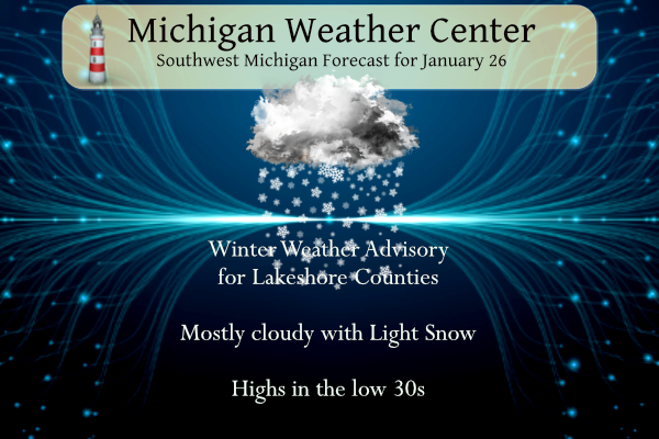
Temperatures will range from lower to mid-30s today. Snow showers, a few of which could be locally heavy, will affect locations mainly between the Lake Michigan shore and US-131. A couple of brief bursts of snow could also make their way toward US-127 late in the day.
We have a Winter Weather Advisory for the lakeshore counties today through 4 am tomorrow:
…WINTER WEATHER ADVISORY REMAINS IN EFFECT UNTIL 4 AM EST FRIDAY…
* WHAT…Snow. Additional snow accumulations of 1 to 3 inches.
* WHERE…Allegan, Muskegon Ottawa, and Van Buren counties.
* WHEN…Until 4 AM EST Friday. * IMPACTS…Plan on slippery road conditions. The hazardous conditions could impact the morning or evening commute.
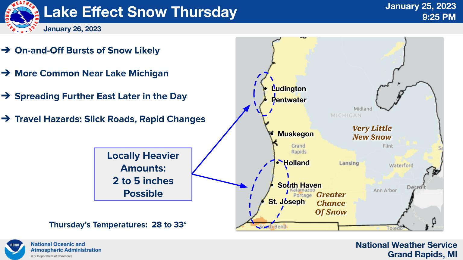
On-and-off bursts of snow are expected Thursday. Several inches of new snow will be possible in a few communities near the Lake Michigan shore.
We have had 5.5 inches of snow this week in Otsego which brings us up to 49.5 inches since November 1st compared to the 31 inches we had last winter at this time.
Grand Rapids Forecast
1 26 grrLansing Forecast
1 26 lanKalamazoo Forecast
1 26 kzoForecast Discussion
-- Lake-effect snow today --

KGRR radar reflectivity, along with recent surface observations,
continue to indicate pockets of light snow occuring as of 3 AM Thu.
This activity is likely being maintained by weak low-level
convergence amid broad, cyclonically curved low-level flow and
persistent low-level moisture. Any accumulation with this activity
early this morning will be very light, but may still contribute to
slippery road conditions. Even where snow is not occurring, icy
patches are possible on roads this morning.

Attention then turns to the lake-effect snow activity that is
already evident on KGRR radar. 850-mb temperatures at/below -8C
will maintain sufficiently steep low-level lapse rates for
continued lake-effect activity today. Meanwhile, NNW boundary-
layer flow early this morning will gradually back NW in the coming
hours, allowing activity to come ashore starting later this
morning.

Within this lake-effect activity today, model profiles suggest
that surface-based parcels may achieve impressive equilibrium-
level heights (near 8 kft)--well into the dendritic growth zone
(the -12 to -18C layer). Additionally, deep background moisture
will be present within/above the convective cloud layer. This
environment will favor efficient snow production in the heaviest
convective elements, although some degree of riming is possible.
Additionally, the long low-level fetch length and weak cloud-
layer shear may allow organization of a broken, quasi-dominant
band, and HRRR guidance suggests that one or several compact
mesolow features may develop along this band axis.

With this update, Muskegon and Ottawa counties will be added to
the Winter Weather Advisory. Snowfall accumulations within the
advisory area (lakeshore counties) are generally expected to range
from 1-4 inches through this evening, and marginal surface temps
will allow some melting. However, within the heaviest snow
showers, quick reductions in visibility and slippery road
conditions are expected.

-- Mainly synoptic snow on Fri; windy --

A midlevel shortwave trough and associated vort max--currently over
northern Alberta--will continue southeastward through tonight, with
an accompanying surface low reaching the vicinity of northern MN by
12z Fri. A brief period of lake-effect snow is possible early Fri
morning as southwesterly boundary-layer flow strengthens.
Thereafter, a period of steady synoptic snow is likely from Fri
morning into the afternoon, driven by strong QG forcing for ascent
accompanying the midlevel trough. Light accumulations (generally 1-
3") look plausible across much of the forecast area.

Additionally, strong southwest winds will develop on Friday, with
growing confidence in gusts of 40-50 mph, particularly along the
lakeshore from Muskegon County northward.

-- Additional synoptic snow on Sat into Sat night --

Models suggest that a west-east-oriented baroclinic zone will be
situated over the region on Sat.  Along this baroclinic zone, broad
midlevel confluence and associated deformation will contribute to
midlevel frontogenesis over the region on Sat into Sat night, as
evident by 850-500-mb Q vectors oriented toward warmer air. This
environment will favor precipitation production within mesoscale
snowbands, and model guidance suggests that greatest snowfall
accumulations (perhaps 3-6") may occur within a relatively narrow
axis. Confidence is currently low regarding the positioning of this
axis, but recent EPS precip exceedance probs suggest that a position
somewhere between the I-94 and I-96 corridors is most likely.

-- Mon and beyond --

EPS and GEFS means show broad agreement regarding the
placement/evolution of large-scale height anomalies into midweek.
The midlevel anticyclone currently over the NE Pacific (near 130W)
is expected to retrogress somewhat and amplify, becoming established
over the Gulf of Alaska on Fri-Sat. Downstream, subsequent midlevel
height falls will occur over the Rockies on Sun-Mon, yielding a
pronounced trough across the western CONUS into Tue. Split flow
aloft will likely develop across much of North America on Sun,
with the polar-front jet extending from the central Rockies into
SE Canada, and a subtropical jet extending from the Baja Peninsula
into the southern CONUS. This southwesterly, split-flow regime
will foster somewhat active weather across the eastern CONUS next
week.

However, aside from these broad features, forecast uncertainty is
rather large from Mon onward. Numerous EPS and GEFS members produce
light snow over the forecast area on Mon in conjunction with a weak
surface wave propagating along a baroclinic zone through the Ohio
Valley. Ensemble guidance suggests additional chances of precip
(likely as snow) during the Tue-Wed timeframe.
Snow, snow, snow!
1-2 inches with no systems in sight lol… over 4 inches out in my hood with plenty more SNOW on the way just the facks baby rock n roll will necer die …INDY
I know I am very late with this, but I had to take my oldest son to the hospital this morning (it was a planned procure) Well Lower Michigan finally had it first widespread snowfall of January 2023. The snow fall looks and feels more like a late fall or early spring snow fall. It was a wet snow fall and it stuck to the ground and trees but not so much to the paved streets or sidewalks. Here in MBY I have a total of 3” on the ground. Here are some H/L and official snow fall amounts from… Read more »
Wow that band in Allegan county is really intense. I’d imagine there will be some crazy totals if it holds up much longer
It’s starting to slowly move north. I’m sure there will be some pretty good totals from down in that area.
News 8 just had a nice graphic on TV
Average snowfall thru this date is 46.5”
We stand at 72.2” currently
For comparison last year we were at 44.8”
So we are 25.7” above average to date and 27.4” more snow than last year to this point. We are going to add to that this weekend.
And yet we’ve had very few days with significant snow on the ground! How ironic.
It’s has no question come in very big batches. I find it pretty impressive how we racked it up so fast.
As for snow on the ground. At Grand Rapids the 30 year average of 1″ or more on the ground in November is 3 this year there was 9. In December the average is 14 this year there was 14 and if there is that 1″ the rest of this month the month of January will end with 8 the average is 23.
Slim
Isn’t it fantastic that winter is back and we a lot of cold and snow in the forecast?
74 inches of snow now for the Winter season closing in on 80!! Out in my hood wow to the wow …. INDY
We are right on track for the RDB seasonal snowfall prediction of around 90 inches! What a winter! Wow to the wow!! Keep the snow rocking!
The trees are all coated here. And there is some sun filtering through the clouds. I’ll happily take this on January 26th… it could be a lot worse!
At the loves travel center along 196 in the Holland area and it’s snowing pretty heavily here as that band moves inland. Some snow/slush buildup on roads
29 warm days in a row and counting! Longest mild streak we’ve ever seen in the winter?
Looks like it may be the 2nd longest mild streak the longest was in 1931/32 that lasted a total of 51 days.
Slim
I would imagine more Winter weather advisorys coming for west Michigan because we have more snow on the way .. wow to the wow … INDY
What? Winter is not over? We have more accumulating snow coming? How is that possible?
Who wouldn’t want snow this time of year? Keep it rocking! Incredible!
4-5” fell around the capital city. Only an inch or two on the driveway and sidewalk so I made quick work of clearing it. I enjoy nature’s insulation – the quietness after a fresh snowfall.
Thank God, we are back into a mid winter pattern! Snow chances galore and cold temps! Nothing better! Rock n roll will never die!