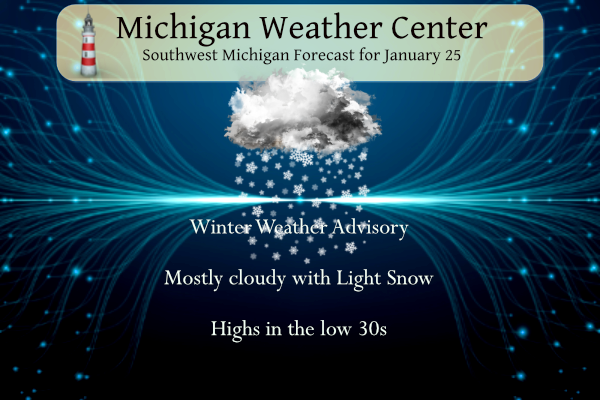
We have a winter weather advisory until 10 pm for three to six inches of snow. Snow will spread from south to north this morning as low-pressure moves across IN/OH. Accumulations of 3-6 inches are expected along the I-94 corridor…highest near Jackson. Two to three inches are expected along I-96 including Grand Rapids with lesser amounts north of there. Snow will taper off tonight.
This was an eventful week in weather history in regard to snowstorms – showing my age I remember the events of 1967, 77, and 78. The storm in 1967 started with temperatures in the 60s.
I lived in Maine from 1972 to 1974 and saw big noreasters dump snow in the mountains where I lived, with fewer roads to maintain nothing ever closed there. We spent much of our time on snowmobiles anyway.
Weather History for SW Michigan
January 22
1883: Bitter cold arctic air sends the temperature down to 14 below zero at Lansing and 8 below at Detroit. The high for the day at Lansing is 4 below zero, the coldest high temperature ever in the month of January there.
2005: A blizzard drops a foot of snow across southern Lower Michigan with strong winds creating drifts up to 4 feet deep.
January 23
1909: Lower Michigan is in the midst of a three-day stretch of warm weather. Lansing hits a record high of 60 degrees. Grand Rapids reaches 56 degrees, also a record.
1948: Record lows on this date include 19 below zero at Grand Rapids and 13 below at Muskegon as arctic high pressure and deep snow cover have Lower Michigan in the deep freeze.
January 24
1967: A huge storm is gathering over the Plains States. Out ahead of it, strong southerly breezes bring record warmth to Lower Michigan. Lansing soars to 66 degrees, the warmest on record for the month of January.
January 25
1950: Muskegon sets the record high for the month of January at 63 degrees. Grand Rapids also ties their monthly record high of 66 degrees.
1967: Temperatures reach the 60s for the second day in a row across Lower Michigan. However, the spring-like weather is about to give way to one of the greatest snowstorms on record.
January 26
1967: Temperatures in the 20s are some 40 degrees colder than the day before, and heavy snow begins falling, piling up a foot or more along with increasing winds.
The Cleveland Superbomb
1978: A storm known as the Cleveland Superbomb moves north from the Gulf of Mexico and deepens explosively, becoming one of the worst blizzards in Midwest history. From one to two feet of snow falls across southern Lower Michigan, whipped into huge drifts by strong gusty winds. Several new records were set including a new record low sea level barometric pressure of 28.68, observed at 6:00 AM. At least 9 deaths were attributed to the blizzard, most roads were impassable, roofs collapsed under the weight of the snow and the airport in Grand Rapids was closed from late on the 25th until the 27th. Governor Milliken declared a state of emergency and requested additional federal aid for snow removal.
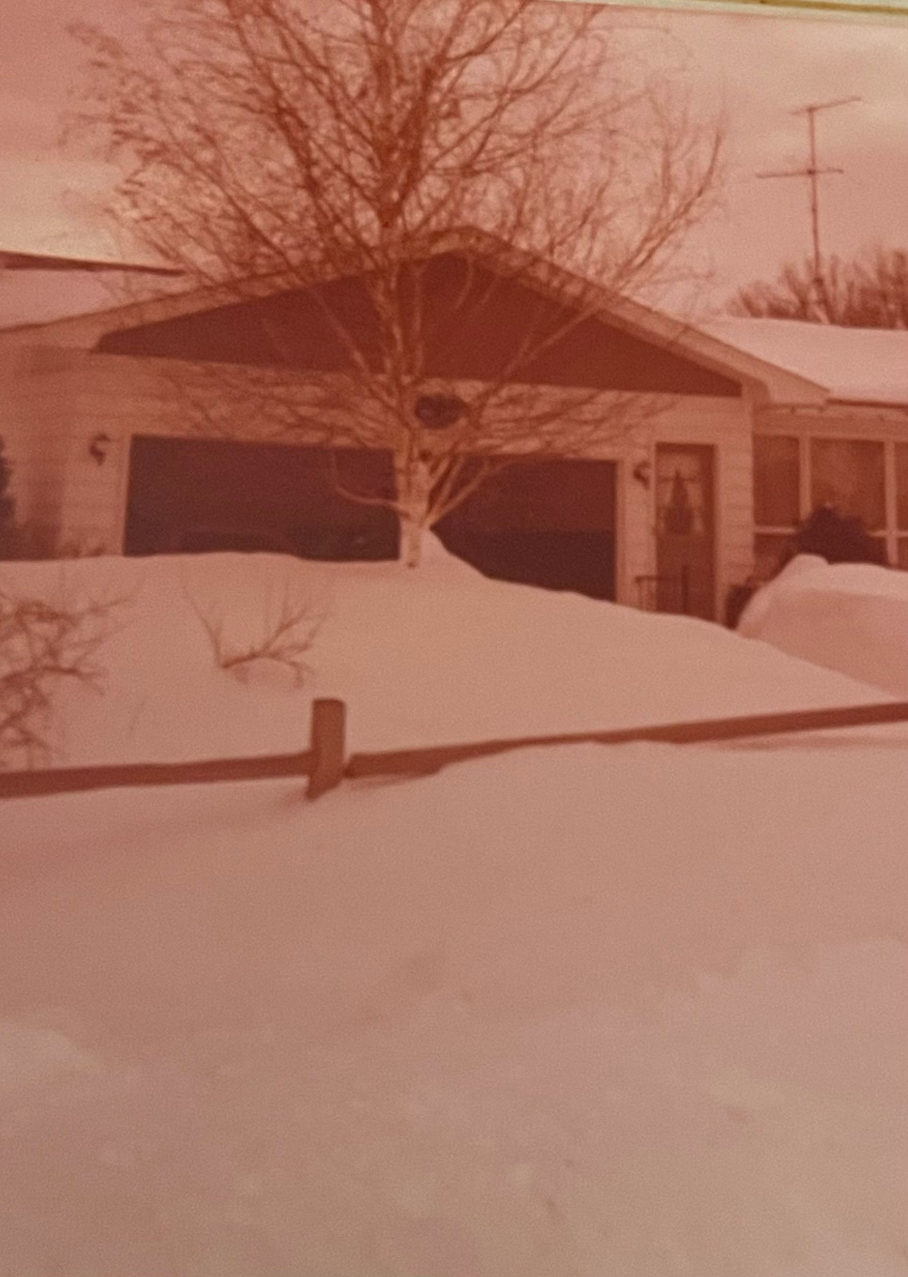
This photo is from Kyle (Portland, Ionia County) taken from his grandmother’s house in Jenison after the 78 storm.
Snowfall Totals
- South Bend, Ind. – 36 inches
- Muskegon – 36 inches
- Jackson – 23 inches
- Saginaw – 22.5 inches
- Kalamazoo – 20 inches
- Grand Rapids – 19 inches
- Lansing – 19 inches
- Flint – 10 inches
- Detroit – 8 inches
Here are some interesting numbers about the 1978 blizzard:
15: foot-high snowdrifts measured in Muskegon County
20: Michigan counties on Red Alert due to “storm of unprecedented magnitude.”
28.68: record low sea level barometric pressure. Measured in Mount Clemmons, it is the third lowest non-tropical atmospheric pressure recorded in the mainland United States.
60: mile per hour wind gusts
125,000: vehicles stranded on roadsides
400,000: people were without electricity during the storm
January 27
1967: Chicago’s greatest snowstorm on record also extends into Lower Michigan, where Battle Creek records 28.6 inches of snow. The storm total at Lansing is 23 inches and 18 inches at Grand Rapids. For more info go here: https://www.weather.gov/media/grr/BillHistorical/Blizzard%20of%201967.pdf
1994: A snow and ice storm brings travel to a halt across Lower Michigan. Freezing rain causes widespread power outages and results in 5 million dollars in damage.
January 28
1977: Buffalo, New York is hit with the worst blizzard in its history. Meanwhile, lake effect snow squalls also pummel areas in western Lower Michigan with more than a foot of fresh snow being piled into huge drifts by strong winds. Though not as bad as the blizzard of 78, it is called the forgotten blizzard.
Weather History for SE Michigan
January 22
On January 22, 2005, an extremely strong “Alberta Clipper” storm system moved through Southern Lower Michigan. This storm dropped 10 to 12 inches across most of the Thumb and Metro Detroit regions. Port Hope in Huron County received a whopping 15.5 inches of snow.
Also on January 22, 2012, the high temperature in Flint rose to only 10 degrees, tying the record minimum high temperature for the date.
January 23
On January 23, 2019, a mix of snow, sleet, and freezing rain was coming to an end across the region. The Thumb saw snow of around 4 inches, while areas to the south saw a coating of ice due to freezing rain/sleet. After the precip moved out, temperatures rose to around 40 degrees through the rest of the day.
On January 23, 1909, a two-day trend brought record-high temperatures of 59 degrees on the 23rd and 58 degrees on the 24th in the city of Saginaw.
January 24
On January 24, 1963, Detroit had a high temperature of 4 degrees and a low temperature of -13 degrees, which equates to a very cold day!
January 25
On January 25, 1950, the daytime temperature soared to 67 degrees in Detroit. The normal high temperature for January 25 is only 31 degrees!
Also on this date in 2007, an intense lake effect snow band hit the thumb, leaving the Lake Huron shoreline areas with 10 to 12 inches of snow.
January 26
On January 26, 2021, a low-pressure system brought widespread snow to the region with 3 to 5 inches observed north of I-69. Much of this occurred during the morning commute with visibilities dropping to around a quarter mile and snow quickly accumulating on the roads.
On January 26, 1978, a blizzard hit southeast Michigan. This caused the lowest all-time pressure to be recorded in Detroit: 28.34 inches!
January 27
On January 27, 1967, a blizzard hit the Saginaw Valley, Thumb, and Flint areas. By the time the snow ended, 23.8 inches of snow had piled up in Saginaw, and Flint was buried under 22.7 inches of snow! This storm was the biggest snowfall in Flint and Saginaw history.
On January 27, 2002, the daytime temperature rose to 56 degrees in Flint, setting the record high for this day. Curiously enough, the very next year on this day (January 27, 2003), the temperature fell to -11 degrees, setting the record low for the day.
January 28
On January 28, 2019, a winter storm impacted the area with the Thumb and Tri-Cities region receiving 7 to 10 inches of snow. The system ushered in the coldest air of the season in its wake with dangerous wind chills occurring for a couple of days following.
On January 28, 1906, Saginaw had a record-high temperature of 47 degrees. For all the record highs recorded in the month of January, this temperature was the lowest. All other record-high temperatures for the month varied between 50 and 62 degrees.
Forecast Discussion
- Snow today -

The bottom line up front is that our current winter wx and marine
headlines look excellent and no headline or significant fcst
changes were needed. A consensus blend of latest higher res short
range guidance continues to indicate that 3 to 6 inches of snow
can be expected across the advisory area today with lighter snow
accumulations north of this area.

The ecmwf ensemble mean has quite consistently shown that the sfc
low will be located near KCLE by 00Z this eve and near KBUF by 06Z.
This will keep the axis of heaviest synoptic snow se of our fcst
area. Relatively highest snow accums to around six inches are
expected in and near KJXN and over our far se counties.

The heaviest snow will occur from mid to late morning through
most of the afternoon coincident with strongest omegas thru the
dgz. Snowfall rates may reach an inch/hr for several hrs near KJXN
in that time frame. In the northern portion of the wx advisory
area including Grand Rapids we expect around three inches of
snowfall today.

By 00Z this eve the deformation zone snow on the back side of the
system will already be east of our area while northerly flow will
keep lake effect snow offshore overnight. Winds backing to the
nnw to nw will allow lake effect snow showers to affect areas
mainly west of US-131 and also well into Kalamazoo county Thursday
as suggested by latest SREF pops. Any accumulations Thursday will
be rather light at generally around an inch or less and perhaps a
localized amount to two inches across western Allegan/VB counties.

- Clipper system to bring snow showers Friday -

A fast moving clipper system will bring synoptic snow enhanced by
Lake MI Friday. Around one to four inches of snow is expected
Friday through Friday night with relatively highest amounts in
that range well to the nw of KGRR.

- More snow Saturday through Saturday night -

Isentropic upglide and mid level frontogenetical forcing to the
north of a quasi stationary frontal boundary off to our south will
combine to bring snow Saturday through Saturday night. A west to
east oriented swath of 2-5 inches is probable for our central to
southern fcst area. Given the nature of fgen banded snow I would
not be surprised if a few locations receive over a half a foot of
snow where fgen forcing is the most robust and persistent.
Parts of Allegan and Van Buren could see up to another 5” of snow for tomorrow. Anyone who lived in Michigan for a while knows better than to think winter is over in January! As a matter of fact April 18th I’ve seen it snow very heavily out turkey hunting in Barry County!
I have picked up officially 4.2” of snow at my house from this system. Still some very light snow falling. We had a very heavy burst just before sunset that really racked up the total pretty fast.
I was on the south side of Grand Rapids to my oldest sons house and I am now back home. The roads in GR are just wet with some sloppy mess on the side streets. There was a period of moderate snow fall on the way back home but now it is back to light snow falling. The temperature in at 31 with that snow falling and there is now 2.5″ on the ground. At this time it looks like there will be several more chances of snow in the next few days and we very well might pick up… Read more »
I just walked out to get the mail. Although the snow is accumulating in the yard, the driveway and street have very little slushy snow.
What a storm and just a sign of things to come for the next 8 weeks! Incredible!
Snow has been light all day until the past hour. Now it’s coming down a pretty good clip. Just let the pooch out – 4″ on the ground.
2.5″ here in my yard.
Slim
Just went outside to measure. 2.5” at my house currently.
That is what I have here as well.
Slim
GR is still sitting well above normal for snowfall and climbing! What a winter!
While a lot of other areas are sitting well below normal for snowfall, especially the lakeshore counties. There have not been very many days with snow on the ground this season. Most of the snow we’ve received has vanished within days or hours.
The CPC shows below average temperatures through February 7. My phone is showing highs not getting to 20 as we kick off Feb. with overnight lows in the single digits. I suppose the colder pockets could go below zero especially with a fresh snowpack. Any snow we get will stick around for a bit with temps like that.
It’s interesting how the 2022 blizzard had more snow, longer blizzard conditions, higher winds, and colder temperatures than the blizzards in the 60s/70s, and yet because it was spread out over about 4 days (instead of all at once in one day) the impacts were not as bad. Also it was mostly a lake effect event, which definitely helped. Although I was stuck in my house for about 5 days, from the Thursday before Christmas through Christmas on Sunday.
The 2022 event was no where near the 1967 or 1978 events. I would call the 2022 event a mini blizzard LOL
Slim
It wasn’t that bad here either.
Agreed it didn’t seem as bad as it should have been when looking at all the metrics, which were mostly worse than the 60s/70s blizzards. Even the 2011 blizzard seemed significantly worse than the 2022 blizzard
No advisories or warnings for Ottawa county and the lakeshore. We’ve received about and inch or 2, but roads and driveways are just wet with the warm ground and temp just above freezing. Hard to believe it’s been about exactly a month since our last inch of snow. Still sitting at around 30 to 35 inches on the season, well below our average for the end of January.
The roads in GR are also just wet at this time.
Slim
Just took a snow depth measurement and here in my yard there is now 2″ of snow on the ground. The roads are mostly wet with some slush on the side roads. The current temperature here is 31 with light to almost moderate snow falling. To the east at Detroit and Ann Arbor were heavy snow is being reported their temperatures are in the 32 to 35° range. So not sure how much snow will stick in that area.
Slim
today in Mount Pleasant is has been snowing constantly but not heavy enough to overcome dark surfaces. It is just too warm. There is about 1” on the ground and the temp is 32f.
And interestingly at my house 25 miles south of Mt. Pleasant we have 2.5” of snow, more than double Mt. Pleasant and the roads are terrible.
NWS Indianapolis and NWS Northern Indiana have had some reports of thundersnow from this system. Looking at lightning data there is thundersnow occurring just east of Detroit over Ontario.
What a storm and still getting hammered!
GR is getting pummeled with snow with plenty more to come! Incredible!
I haven’t had a chance to go outside yet, but from my window it doesn’t seem like much has fallen here yet. The grass and trees are covered in a very thin coat
On This Day In Michigan History On Jan. 24, 1938, the Upper Peninsula was hit by a colossal winter storm. Two people died in Ironwood after 32 inches of snow fell as a result of 30 hours of snow and gale-force winds. Students and workers were trapped at their schools and places of employment because of snowdrifts towering as high as 18 feet tall. Students in Ironwood slept on exercise mats in the gym for four days since buses could not operate in drifting snow. A fire broke out at the Opera House and Masonic Temple in Marquette and traffic… Read more »
At Ironwood in that event January 24th 1938 they reported 5″ of new snow. On the 25th 12″ was reported and on the 26th 11″ more fell and on the 27th 4″ was reported and on the 28 there was 49″ on the ground. It looks like that must have been a very localized event Lake effect event. That in Houghton there only reported 3.5″ on the 24 and 2.5″ of the 25th there was however 40″ on the ground. At Marquette a reported 8″ fell on the 24th and 7″ fell on the 25th
Slim
Lots of good stuff today, thanks MV.
Light snow here and the grass is now covered. NWS GR says 5″ for us today. Local TV mets say 2-4″. Let the games begin…
Just took a snow fall measurement and there is now 1″ of new snow on the ground here. At the current time there is light snow falling with a temperature of 30.
slim
4 inches here thus far.
So much for the accumulating snow going south of GR! So much for winter being over or almost over! So much for no snowstorms in the near future! So much for the warm weather fantasies that are constantly spewed on here! Winter is back baby and enjoy the cold and snow! Face reality!
Yes 4 snow systems up stream for west Michigan with some artic air going into February!! Here we go!! INDY
Let it snow let it snow let it snow … Yes even Zland is getting snow today who knew ??? INDY
I wonder if it snowing in Flint?
I think who you may be referring to might live between Flint and Detroit. If you know what I mean.
Slim
Rock on Slim!
That picture I found in an album of all my grandmas photos. I thought it was probably the 78 blizzard and sure enough it was stamped with that on it.
Currently snowing out in my hood INDY is now at 71 inches of snow for the Winter season .. Looks like we have some serious aric air on the way for next week that would fire up the lake effect as we get closer to the century mark in snowfall DDDDDD INDY
Might get out on those cross country skis this month after all! Stay safe on those roads today everyone : )
I lived in the Bay City area in both the 1967 and 1978 storms. Both storms are what I would call benchmark storms. There has not been anything close to either one since the 78 storm. In both storms there were periods of thunderstorm of snow and very high winds. In 1967 we could not get out of the front door on the house but around the back door there was just around a inch or two of snow and the grass was sticking out. There was no school for over a week. By the time of the 1978 storm… Read more »
Welcome back winter! Despite some of the warm weather fantasies about winter being almost over, nothing could be further from the truth! We have snow and cold coming on a regular basis! Out snow totals will keep going up and up! Get prepared now! Rock n roll will never die! Who wouldn’t want snow this time of year?
Good morning! As has been the case so far this month yesterday was yet another cloudy and above average temperature day. While areas east and south of Grand Rapids seen sun here in GR it was just a cloudy day. The official H/L yesterday was 33/29 there was a reported 0.01” of precipitation of that 0.2” of snow fall and as stated no sunshine. At GRR they reported 1” of snow on the ground at 7AM here at my house that was less at around .25” of snow on the ground. The overnight low both here and at GRR was… Read more »