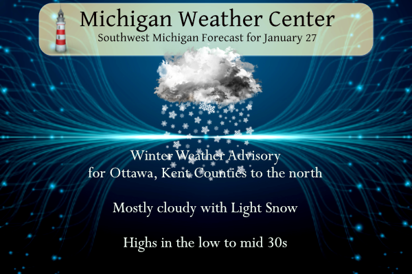
We had a nice band of lake effect set up across southern Allegan County yesterday evening which dropped two or three more inches of snow. I will get out the snowfall measurements later today. With a southwest wind today most of the lake effect will fall from Ottawa and Kent Counties to the north.
From Friday mid-day to evening, freshly falling snow (blowing around in 20 to 30 MPH winds) will produce light accumulations in many places, but 2 to 3 inches are possible especially northwest of Grand Rapids toward Ludington.
Grand Rapids Forecast
1 27 grrLansing Forecast
1 27 lanKalamazoo Forecast
1 17 kzoForecast Discussion
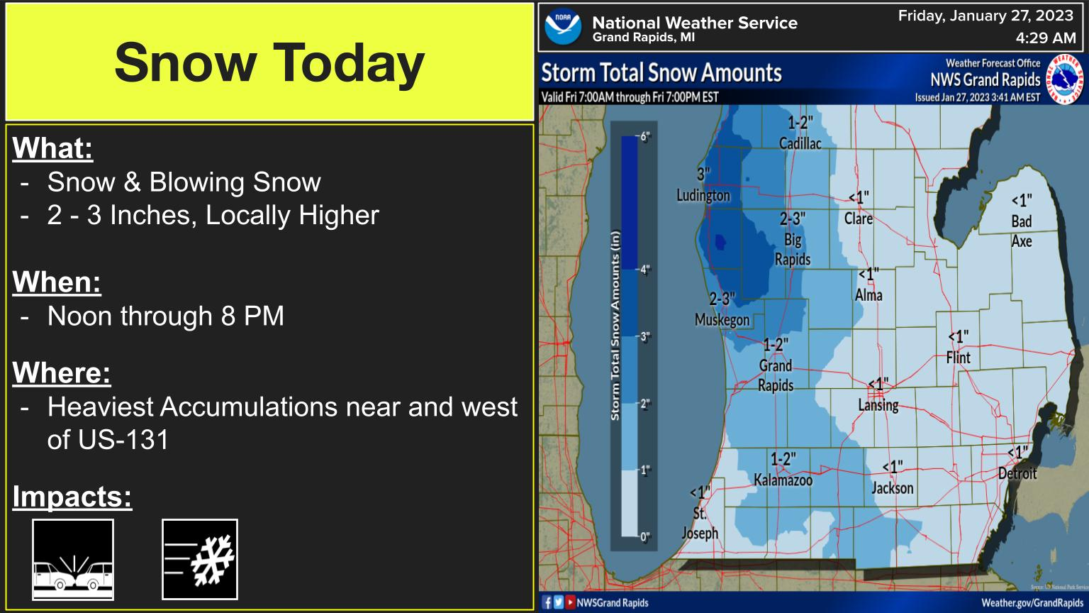
-- Light snow today; windy near lakeshore --

GOES water-vapor imagery early Fri shows a vigorous midlevel
shortwave trough / vort max over the northern plains. Surface
observations reveal an associated surface low (992 mb) over
northern MN, with appreciable surface pressure falls (3+ mb per
2 h) occurring southeast of this low, per RAP mesoanalysis.
Meanwhile, considerable clearing is noted on IR imagery
encroaching on Lower Michigan. While lake stratocumulus is likely
to persist, some sunshine is possible this morning, mainly over
southern counties amid southwest low-level flow.

A swath of mainly light snow, currently evident upstream in regional
reflectivity mosaics, will continue southeastward today, maintained
by strong QG forcing for ascent accompanying the midlevel trough.
HRRR time-height sections indicate fairly rapid column moistening
early this afternoon. The DGZ depth is rather modest (3-4 kft), and
ascent is generally not optimally positioned for best depositional
crystal growth. Still, a period of light accumulating snow is
expected across the forecast area today, with snow likely arriving
at the lakeshore after noon.

Eastward of the advancing surface low and midlevel trough, a low-
level jet axis will traverse the region today. HRRR profiles continue
to suggest that gusts up to 45 mph are possible--mainly near the
lakeshore from Muskegon northward--where steep near-surface lapse
rates will allow downward transport of higher momentum from atop
the boundary layer. These gusts may result in isolated power
outages, but will generally just contribute to blowing snow in
open areas, even with light overall accumulations.

Given the combination of light accumulations and gusty winds /
blowing snow, a Winter Weather Advisory will be issued shortly for
seven counties (Ottawa and Kent northward). Within the advisory
area, total accumulations of 1-3" are expected, but isolated higher
amounts are possible. Slippery travel is again expected today--
especially in the advisory area--and the afternoon/evening commute
is likely to be affected in many areas.

-- Snow on Sat into Sat night, some mixed precip possible --

On Sat, a surface wave beneath the right-entrance region of a 130-kt
upper jet will move eastward into the Ohio Valley along a pronounced
baroclinic zone. Northeast of this surface wave, midlevel
confluence/deformation will result in an elongated region of
frontogenesis that will progress through the area on Sat into Sat
night. This frontogenesis, in conjunction with the jet streak aloft,
will drive a transverse frontal circulation--likely resulting in a
period of mesoscale-banded precip (mostly snow) across southern
Lower Michigan.

The axis of highest EPS probs of 3"+ snowfall (using a simple 10:1
SLR) has shifted slightly northward in recent runs and now roughly
coincides with the I-96 corridor. Within this area, 3-6"
accumulations look plausible. A northward shift in the axis of
heaviest snow is also noted in some deterministic runs, including
the latest ECMWF, HRRR, and 3-km NAM. However, this shift also
raises the possibility of mixed precip types across the far
southern forecast area, where thermal profiles suggest that sleet
or freezing rain are possible. For now, an all-snow forecast will
be maintained in this package, but later shifts will need to
assess p-type contingencies across the far south. Another Winter
Weather Advisory will likely be needed for portions of the
forecast area during this timeframe, with travel-related impacts
likely to develop on Sat and persist into Sun.

-- Mon and beyond --

Recent ensemble guidance has trended somewhat more progressive in
building a strong surface anticyclone (around 1035 mb) into the
region on Mon night and Tue. This trend has been accompanied by a
southward displacement of the active baroclinic zone away from the
region by midweek, suggesting reduced chances of widespread synoptic
precip in the forecast area. Below-normal temps are likely during
this period, with subzero lows possible, particularly if any
clearing materializes.
Get ready for the snowstorm tomorrow! Incredible!
Getting a steady rain now with the temp up to 34. Be interesting to know just how much rain we’ve had this January.
Too funny! Only in Zeeland or Flint would that be possible!
Nothing really funny about it. Rain is rain. You can see it on hollands hourly report.
https://w1.weather.gov/data/obhistory/KBIV.html
Like I said, absolutely hilarious!
GR reports the same. Not sure why that’s funny. Just facts.
https://w1.weather.gov/data/obhistory/KGRR.html
Hilarious!
Nice map and GR may get absolutely pummeled just 2 days after some people said no accumulating snow in sight! Too funny!
https://www.weather.gov/grr/weatherstory
Perfect weather ahead to enjoy all this snow as well!
You know it! I will be skiing and snowshoeing all week! I love it!
Getting light snow and blowing snow here at the current time. Temperature is now at 24 here in MBY.
Slim
No snow falling here, in fact there is some filtered sunshine at this time. There is also some wind. The temperature is 27.
Slim
The sun has been out here for the past two hours. Breezy.
It sure is chilly out there right now. Feels like 7 currently
I Imagine by Monday morning GR will be knocking on 90 inches of snow who knew?? INDY
There is a report from a credible source to the NWS in Grand Rapids of nearly a foot of snow in Valley Township, Allegan County which is just west of Allegan and East of Fennville. That foot would have fallen since 4pm yesterday under that firehose band.
I saw that. It’s five miles west of Allegan on Valley Rd on the southside of Lake Allegan. 10 inches in just six hours. That is impressive.
They must have been in the perfect spot as the band was lifting northward… that’s probably 2 inches per hour for 6 hours
Get ready >>>>back to back clippers may be heading to a neighborhood near you! GR should have at least 6 inches of fresh snow by the end of the weekend! Wow to wow! The snow and cold just keeps coming baby. Rock n roll will live forever!
The temperature has really dropped here in MBY. It has fallen from 24 to the current reading of 20 in less than one hour.
Slim
The sun peeked out yesterday and temps were above freezing, so we lost some of what we received earlier in the week. More importantly, the roads are clear. Local TV met thinks we could get an additional 4” by Sunday.
Good morning! The heaviest of the lake effect snow yesterday fell just south of the Grand Rapids area. So while there were areas of much more of snow to the south here in GR just over 1” fell. The official H/L was 33/27 there was 0.09” of precipitation and that 1.1” of snow fall. The sun did come out for a couple of minutes for a 1% of possible sunshine. There was 3” of snow on the ground yesterday at 7AM. The overnight low so far here at my house is the current temperature of 24 with some breaks in… Read more »
Yesterday the question was asked if. 29 warm days in a row and counting! Longest mild streak we’ve ever seen in the winter? Looks like it may be the 2nd longest mild streak. The longest was in 1931/32 that lasted a total of 51 days. And as for how long there has been snow cover at Grand Rapids this winter season. As for snow on the ground. At Grand Rapids the 30-year average of 1″ or more on the ground in November is 3 this year there was 9. In December the average is 14 this year there was 14… Read more »