SPC Forecast
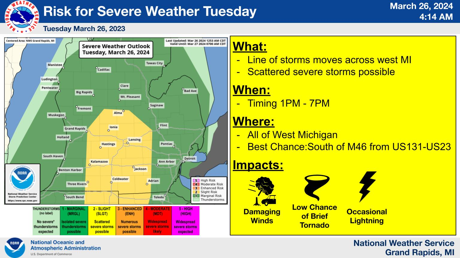
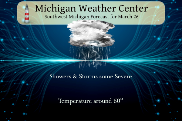
Scattered thunderstorms are expected to move across lower Michigan this afternoon. Some storms may be severe. Damaging winds and lightning are the main hazards though a brief tornado cannot be ruled out. The highest risk is south of M46 between US131 and US23. Stay weather-aware today.
NWS Forecast
Weather History
1934: A record snowstorm began across southeast Lower Michigan with around a foot of snow falling at Jackson, Lansing, and Battle Creek. Snow totals dropped off quickly to the northwest with Grand Rapids getting only about an inch.
1993: Dense fog caused a fatal airplane crash at Ludington. The pilot was trying to land in near zero visibility and collided with trees and terrain on his second approach to the airport. The pilot was seriously injured and his wife, the only passenger, was killed.
On March 26, 1968, an F2 tornado hit Monroe County causing approximately $250,000 in property damage.
Also on March 26, 2007, the temperature soared to 81 degrees in Detroit breaking a record for the date. Flint and Saginaw both hit 76 degrees. On the next day, Detroit once again hit 81 degrees to set a record. Detroit has only reached 80 degrees or higher 12 times in the month of March, twice in March 2007.
1948: Good Friday tornadoes moved from Terre Haute to Redkey, Indiana killing 20 people. About 80% of the town of Coatesville was destroyed, and 16 people were killed. The Coatesville Carnegie Library was a total loss. The path was a half mile wide.
2009: The proof is in the pudding – A NOAA Weather Radio can save your life. Near Belk, AL, a family was alerted to a tornado by their weather radio; they went to their storm cellar. They heard the “jet roar” of the EF1 tornado as it damaged their home; they were unhurt.
Forecast Discussion
- Strong/severe storms today

As expected, rain developed over the cwa within the past few
hours. Radar shows the showers moving quickly north. At this time,
no thunder has been detected. Farther southwest, the dry slot is
beginning to develop over Illinois and this will be a key to our
weather today.

A surface low was over central Iowa with a trough trailing south
and a cold front behind it. The low is progd to continue to
deepen as it tracks toward the western UP.

Today`s scenario involves the rain moving north and the drier air
of the dry slot moving over the cwa later this morning/early
afternoon. Coincident with this will be the trough/cold front
moving east across Lake Michigan. Soundings and forecast upper air
progs shows a lot of wind aloft. As this occurs, mid level lapse
rates near 7C/km will nose northward from Ohio. MUCAPE isn`t all
that impressive; a few hundred joules/kg. But if we get enough dry
air to move in following the rain, the degree of destabilization
may overperform a bit. Moisture isn`t great, but probably enough
for some storms to develop. Helping the cause for storms will be
the additional lift from the associated short wave that also
arrives around 18z.

CAMS show a broken line of convection developing along/ahead of
the front by early afternoon over the western cwa and moving
east. Given a LLJ around 50 knots and a mid level jet around 110
kts, any storm that develops could generate severe wind gusts.

0-3km SRH values top out in the 300-400ms range on the HRRR, which
is probably enough to generate some rotating supercells.

There appears to be more than enough ingredients coming together
to generate some severe wind gusts and/or an isolated tornado. SPC
has placed the cwa south of M-57 and east of the lakeshore in a
Slight Risk for severe storms today with the rest of the cwa in a
Marginal Risk. The threat window looks to be 2PM - 7PM.

Cooler air will move back into the cwa behind the front tonight.
Dry weather is expected Wednesday.

- Dry to End The Workweek

No impactful weather is expected Thursday or Friday as surface and
upper-level ridging, in tandem with a overall dry atmosphere, drives
conditions across the Central Great Lakes. The dry air in place
means plenty of sunshine is expected. Highs in the 40s are expected
Thursday as longwave troughing exits, with temperatures climbing
into the 50s for Friday under increasing mid-level heights and a
brief thermal ridge.

- Multiple Chances For Precipitation As March Ends

The weekend into the first part of next week will feature a mainly
zonal 500mb pattern with a mid-level baroclinic zone not far to the
north. Ensemble guidance suggests a few chances of precipitation
centered around the Saturday Morning, and Sunday Night - Tuesday
timeframes as surface lows move through the Central Great Lakes.
However, as is not uncommon in the extended range and especially in
a zonal flow pattern, exact details remain uncertain as to timing
and amounts. A high pressure system in the Hudson Bay region and
associated northerly component to the flow pattern brings the
potential of snow showers mixing in across Central Michigan near
peak overnight cooling. The zonal pattern also keeps temperatures
generally consistent in the upper 40s to near 50s through the
weekend and into Monday.
Possible snowstorm coming in July get prepared now! Some people say possible snowstorm in every month, might as well include the summer months to complete their insanity!
Cold weather crazies with predictions of 80+ inches of snow this winter are crazy delusional as usual.
Breaking Winter Weather Alert!>>>>>possible snowstorm the fist week of April! Wouldn’t that be fantastic!
Wind chills around 20 degrees in late March = incredible!
Seeing as winter weather is done, tomorrow should be a great day to golf. Highs in the mid 30’s with wind and wind chills around 29 degrees all day! The warm weather delusions are off the charts! Too funny!
A snowstorm in mid March where GR sets a daily snowfall record and then it all melts the next day = nothing better than that!
And we’re still about 3 feet below normal on seasonal snowfall = even better!
Plenty of snow all day on Saturday as went on an epic snowshoe hike! Your delusions are off the charts!
A snowstorm in mid March where GR sets a daily snowfall record = nothing better other than a snowstorm in early April!
Warm winter and warm spring!!! Doesn’t get any better than this!
* Severe Thunderstorm Warning for… Eastern Allegan County in southwestern Michigan… Western Barry County in southwestern Michigan… Kalamazoo County in southwestern Michigan… * Until 300 PM EDT. * At 216 PM EDT, severe thunderstorms were located along a line extending from 5 miles southwest of Otsego to 6 miles northwest of Westwood to near Marcellus, moving north at 50 mph. HAZARD…60 mph wind gusts. SOURCE…Radar indicated. IMPACT…Expect damage to roofs, siding, and trees. * Severe thunderstorms will be near… Kalamazoo, Portage, Otsego, Plainwell, Schoolcraft, and Westwood around 220 PM EDT. Martin around 225 PM EDT. Wayland and Parchment around 230… Read more »
All this rain and warmth is really greening up the outside!
…Showers and storms to impact the area through this afternoon… Scattered to numerous showers are developing over the area early this afternoon. These showers will have the potential to produce some wind gusts of 40 to 50 mph. Additional showers and a few thunderstorms across Northeast Illinois and Northwest Indiana as of noon EDT will continue to increase in coverage and intensity as these move toward Lower Michigan through mid-afternoon. The strongest storms will have the potential of becoming severe with wind gusts of 60 mph being the main threat. There is also a small chance of a brief and… Read more »
Breaking>>>>we have plenty of cold weather coming this Spring with a lot of freezing temps and maybe more SNOW! So forget about an early warm Spring! Not happening!
Weather looks pleasant coming up. Flowers are very early this year and thriving. I love early springs!
Flowers and plants are at least 3 weeks ahead of schedule that could lead to a frost/freeze issue in the next month or so. And that could happen with average temperatures. At this time we are still way behind what we were in 2012.
Slim
I could see a warm pattern in early/mid April, and then a quick shot of cold air later in the month, being a serious issue for crops. But we will see, obviously it is really hard to predict this far out
It looks like smooth sailing to me for most plants. Way ahead of schedule. Fruit plants are the one exception – but that is an every year worry living in Michigan.
Get ready for a big cold front! Get ready for about a 30 degree temp drop and wind chills in the upper teens to low 20’s! That is very cold for late March! Wow, just wow, WOW!! Still getting winter time temps despite the warm weather fanatics telling us winter has been over for months! Incredible, but facts are facts!
The overnight low here in MBY was 48 there was 0.15” of rainfall. With cloudy skies the current temperature is 49. Even after recent period of 7 out of 8 days below average the mean for March is still at 41.2 and that is +6.7 March is above average is participation with 3.10” (1.84 is average) and snowfall 7.2” (6.9”) is average. Note that 7.2 for the month is average so we still could be average for the month.
Slim
The official H/L yesterday at Grand Rapids was 63/33. There was no precipitation the highest wind gust was 29 MPH out of the SE. The sun was out 14% of the possible time. For today the average H/L is 49/30 the record high is 77 in 1976 the record low of 6 was set in 1996. The wettest was 1.20 in 1948 the most snowfall of 10.2” fell in 1970 the most on the ground is 13” in 1965. Last year the H/L was 49/30 and there was 0.19” of rainfall.
Slim