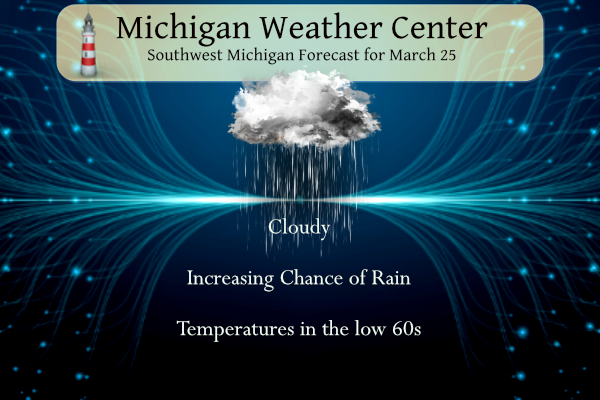
We have a classic spring day in store with warmer temperatures and increasing chances of rain. Temperatures will warm to the low 60s.
SPC Forecast
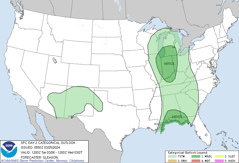
Day Two Outlook
NWS Forecast
Weather History
1954: Heavy rain and high winds occur as a cold front moves through. Grand Rapids measures 2.82 inches of rain for their wettest March day on record. Flooding of streams is widespread and winds gusting over 70 mph cause roof damage and uproot trees.
1974: Grand Rapids falls to one below zero for its latest subzero reading on record.
On March 25, 1945, record high temperatures for the day were set simultaneously in Detroit (78 degrees), Flint (79 degrees), and Saginaw (80 degrees)!
Just two years later on March 25, 1947, a snowstorm dumped 13.3 inches on Saginaw. This was the 11th heaviest snowstorm in Saginaw history.
1901: More than 20 people were killed by an estimated F3 tornado that moved across parts of Birmingham, Alabama. The twister cut a 15-mile path from the south side of the city to Avondale and Irondale.
1935: Suffocating dust storms frequently occurred in southeast Colorado between the 12th and the 25th of the month. Six people died, and many livestock starved or suffocated. Up to six feet of dust covered the ground. Schools were closed, and tenants deserted many rural homes.
1992: Hailstones up to four inches in diameter resulted in more than $60 million in damage in Orlando, Florida. This storm is still the costliest Florida hailstorm on record.
Forecast Discussion
- Warm, Windy Today and Tomorrow

Bottom line up front: Warm air advection and a strong low level
jet will bring warmer temperatures through mid week with gusty
winds today and tomorrow with upwards of 40 mph winds possible
tonight and tomorrow. A wind advisory may be needed. Showers are
expected Monday night through Tuesday with storms possible Tuesday
afternoon with a marginal risk of severe Tuesday afternoon and
evening. Damaging winds is the primary concern.

 The first half of the week will stand in great juxtaposition to
the end of last week. Temperatures are around freezing this
morning will rise to the low 60s this afternoon. Those Max Temps are
10 to 15 degrees above normal. Those warm temperatures this time
of year comes at a cost. That cost is that they are accompanied by
strong south easterly winds.

 A large upper level trough situated over the intermountain west
will close off as it moves eastward. This barotropic system will
displace the high pressure that has been over the Great Lakes the
last few days. 850mb temperatures this afternoon and evening will
be upwards of +7C. With that surge of temperature along with the
tightening pressure gradient expect gusty winds today into tonight
in the 30 to 35 mph range.

 Lower Michigan will clearly be in the warm sector as the warm
front from this system will move through the U.P. and into
Southern Canada. The low will continue its trek eastward into
Tuesday. The winds throughout this system are strong with NAEFS
anomalies into Tuesday will be +3 STD above normal. Expect a 50
to 60KT LLJ to move over the region tonight into tomorrow. The
only limiting factor is whether or not those winds will be able
to mix down, considering it is propagating through at night. The
cold nighttime temperatures will create a decent inversion that
any upper level forcing will need to overcome to allow the strong
low to mid level winds to reach the SFC.

 The system is fairly barotropic with little to no directional
shear. There is also decent PWAT and Specific Humidity through
the system. NAEFS currently has +1 STD PWATS at 06Z Tuesday. If
water loading is taken into account during frontal passage, that
should overcome the inversion mixing down the 60KT jet to the SFC.
That could translate to 45 mph winds or more during frontal
passage. As stated previously gusts of that magnitude are of the
advisory criteria, the question is for how long.
 After frontal passage the winds will remain strong aloft,
However the inversion will be present until Tuesday afternoon. So
periods of strong, possible damaging winds, will be possible
during that timeframe.

- Rain with possible storms Tuesday, some storms could be severe

 Bottom line up front: A frontal system with strong low level wind shear
will move through the area Tuesday bringing showers and storms
with damaging winds possible. The strong shear could make storms,
Tuesday afternoon severe. For these concerns SPC has put most of
the Southern half of Lower Michigan in a Marginal risk for severe
storms.

 The strong, potent and closed low will continue its trek through
midwest and make its way east through the Great Lakes Monday night
through Tuesday. Warm air advection out ahead of the system will
reduce any inversion that could limit the effectiveness of the
strong winds aloft to reach the surface. The strong pressure
gradient will bring a strong front through the region Tuesday.
Latest CAMS show 0-6KM wind shear upwards of 80kts Tuesday
morning. An initial band of showers will move through early
Tuesday. Strong gusty possible damaging winds should accompany
that line. Expect brief heavy downpours through overall QPF is
only expected to be around a half an inch. Behind that will be the
cold front that will also have a persistent jet with it. Though
MEAN CAPE is low, with only 100 to 200 J/kg ahead of the front
Tuesday afternoon. The CIN associated with this system is at best
20 J/kg. Given that the frontal rain band will move through
between midnight and 9 AM Tuesday there will be copious amounts of
moisture in the air. So with very little to overcome and given
that temperatures on Tuesday are still expected to reach into the
upper 50s there will be a warm, moist air mass that the incoming
system will move into.

 Latest CAMS have simulated reflectivities showing a QLCS pattern
which isn`t surprising given the strong shear vectors. Though
there is very little CAPE there is a lot of research that shows
High shear, low CAPE supercells are possible. Given that the 0-6KM
shear will be 60kts during this time with 200 J/KG SPC covered
Southern Lower Michigan in a marginal risk, with damaging winds as
the main threats. Lower end tornadoes given the shear and given
potential for a QLCS are not out of the question.


- Cooling back down for Wednesday

Stronger cold air advection persists Tuesday night into Wednesday,
sending the temperatures back down to colder than normal levels. The
low level thermal trough arrives Wednesday afternoon and lingers
into Thursday.   Ensemble max temperature suggest the CWA will stay
in the 30s for Wednesday and upper 30s to mid 40s for Thursday,
which is at least several degrees below normal.


- Risk for some showers mainly over the weekend

A southwesterly low level jet forms upstream Friday and reaches into
the OH Valley on Saturday. Meanwhile aloft over the Great Lakes
Region we will see a west northwest flow persisting. This pattern
supports a strengthening baroclinic zone over the area Friday night
into Saturday. Gulf moisture will be advecting northward and into
the Lower Great Lakes Region with PWATs once again approaching an
inch then. As this moisture interacts with strengthening frontal
zone, scattered showers could form. The frontal zone is forecast to
slip slowly south into Sunday, and that may focus the highest rain
chances south of the CWA.
Get ready! Major April cold air is coming! WOW!
A decent amount of sun here this afternoon. It just clouded up. 65 degrees and our golf course has zero tee times available. Methinks everyone played hookey this afternoon.
Most courses here were not open because of snow still on the greens and the course!
Get ready for the cold front! Incredible!
Well it’s 60 today, another joke of a prediction!
Rocky (Rockford)
If you like nice warm Spring/Summer temps – forget about it! This week = winter temps and you will not see a temp as high as 60 degrees for at least the next 3 to 4 weeks! You will see plenty of highs in the 40’s to low 50’s with wind! Summer temps are many, many, many weeks away, so get used to cold and cool temps!
March 19, 2024 3:13 pm
Whoops! Nice catch
He’s got zero credibility!
A big cold front barreling through Tuesday afternoon and then temps down into the mid 20’s! I love it!
60’s with a chance of severe storms tomorrow? I love it!
It was another cold and windy day yesterday with the official H/L of 40/22 there was no rain/snowfall. The highest wind gust was 33MPH out of the E and the day had 24% of possible sunshine. The average H/L for today is 48/30 the record high of 77 was set in 1945 and the record low of -1 was set in 1974. The most rainfall of 2.85” fell in 1954 the most snow fall of 7.7” fell in 1930 the most snow on the ground was 15” in 1965. Last year the H/L was 37/32 there was 0.89” of rainfall… Read more »
Get ready for another big cold front! This after a multi day stretch of well below normal temps! WOW, just wow, WOW!!!
What a sunrise this morning! The east horizon was on fire. So pretty.
That was not the case here in my area the cloud cover is already here.
Slim