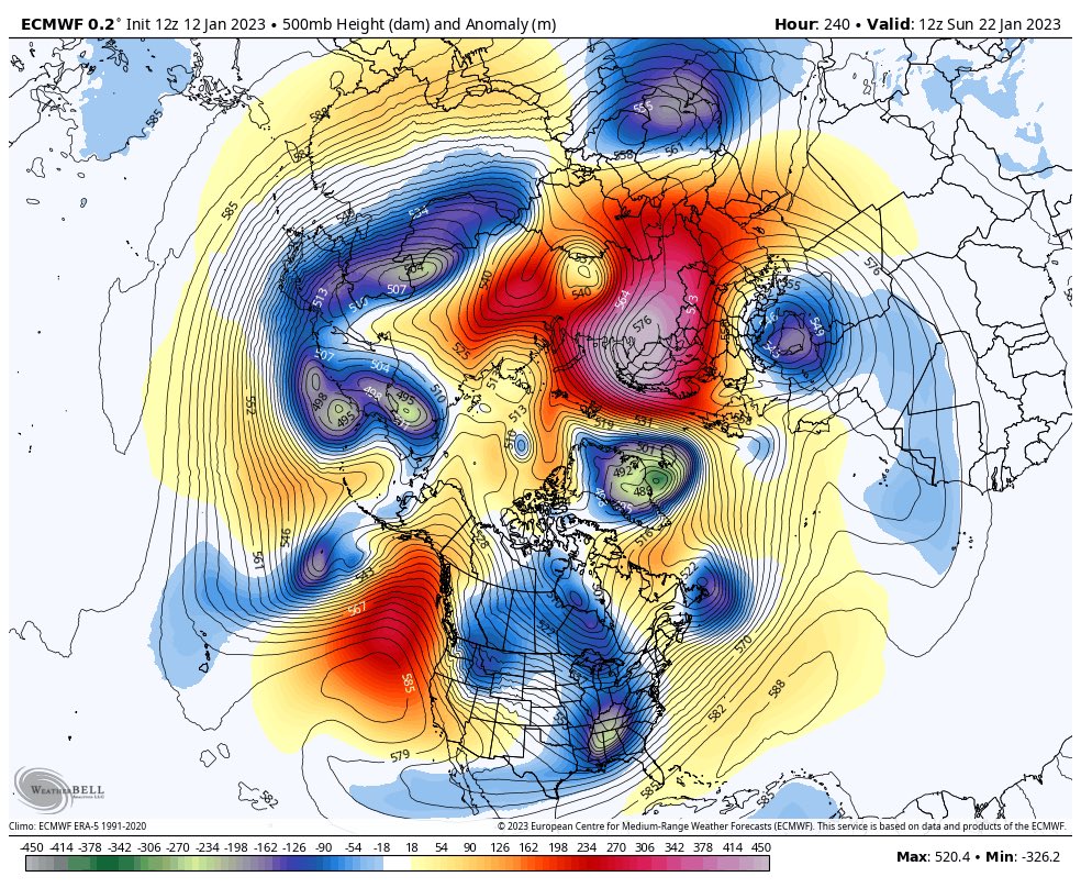
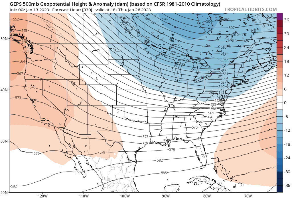
There are many models we look at when trying to predict long-range forecasts. To be sure there is no certainty they will play out as we wish to see them. There are a few of the models which are predicting a long-term cold shot from the polar vortex in late January into February. This begins with the warming in the Arctic stratosphere which pushes the cold air south (simply put). The GFS, GEFS, ECMWS, and GEM models are displaying similar model runs. This is more of a heads-up than anything else. Do with it as you will, it is my humble opinion that winter in the sense of cold and snow isn’t over yet. We will see if the CPC comes on board with this. Below is just a brief example of what the models are seeing.
Inland areas along/north of I-96 have the best chance of afternoon sunshine today. Dry weather will continue over the weekend with more opportunities for sun, especially on Saturday.
Grand Rapids Forecast
7-Day Forecast 42.96°N 85.67°W 1 13 grrKalamazoo Forecast
7-Day Forecast 42.29°N 85.58°W 1 13 kzoLansing Forecast
7-Day Forecast 42.71°N 84.57°W 1 13 kzoForecast Discussion
-- Likely clearing out tonight into Saturday --

The most interesting thing to happen for the next few days will be a
rare opportunity for sunshine and clear nighttime skies this
afternoon through Saturday. Upper-level ridging and broad scale mid-
to-low-level subsidence should start opening up some holes in the
clouds during the afternoon, starting in the interior northern part
of the peninsula and spreading southward. Additionally, in north
flow with dry-air advection, further drying is promoted (slightly)
by downsloping flow off the higher terrain of the central/northern
lower peninsula. One can hope anyway that all these factors combined
do act to evaporate the clouds; and the chance does appear greater
this time compared to last week Saturday.

With any clearing over land tonight, radiational cooling should
reinforce the nocturnal land breeze circulation and keep lake-effect
clouds confined to the lake or near the shoreline. Low temperatures
tonight may drop to near/below normal for the first time since Dec
27. With the expectation of clearing, lowered the min temp forecast
tonight against NBM by going with a consensus of MOS guidance.
Clouds may start to lean back in to the lakeshore areas Saturday as
winds become more westerly. High altitude clouds will move in and
likely filter out the sun on Sunday.

-- Rain likely Monday to Monday night --

Winter will come back eventually, but not yet. Southerly warm-air
advection resumes Sunday as the ridge translates to our east. The
next synoptic trough will develop a Colorado Low Sunday which will
track into Iowa on Monday. From there on its way to Michigan Monday
night, the central surface pressure of the low should gradually
increase while the low at 500 mb starts opening back up. We will
be in a favorable part of the jet for lift (poleward exit region),
though the core of the jet streak is quite flat/zonal and focused
to our south. Ensembles of the GFS, ECMWF, and CMC are consistent
with median rainfall amounts in the range of 0.2 to 0.4 inches,
with tail-end solutions around 0.1 and 0.75 inches. There is a
chance of a small amount of freezing rain at the onset Monday
morning in the interior of central Michigan, near and north of
US-10, owing to dry near-surface air initially in place that would
enable web-bulb temperature to potentially dip below 32.

-- Wintry precipitation possible Thursday to Thursday night --

The next low in the wave train for Thursday has some potential among
the ensemble solution envelope to provide wintry precipitation with
a reservoir of marginally sufficient cold air to pull in from the
northern Midwest, but much will depend on the low`s track and
poleward extent of of warm air advection on the front side of it.
The spread in the QPF solutions not surprisingly is larger than
with Monday`s system, so despite likely PoPs on Thursday, the
range of potential impacts, or lack thereof, is still wide.
1. GR is well above normal for seasonal snowfall!
2. We get some of our biggest snowstorms in Feb!
3. Many La Niña winters are back loaded with cold and snow!
4. Thank God we have multiple months left with snow chances!
5. Cold and snow rocks!
While most years the last week of February is warmer than the first two to three weeks. In recent years 2021, 2020, 2015 and 2013 seen Februarys that were colder than January. 2015 stayed cold until the very end of February. But remember the days are longer by then and even when it is cold if it is sunny the sun will melt the snow.
Slim
1. Next week might be even warmer than this week
2. February 2016, 2017, and 2018 all saw nothing but 40’s, 50’s, and 60’s the back half of February
3. We are about half way through met winter
4. This has been one of the worst winter sports seasons I can recall
Grandkids have not had much sledding on the hill this year.
Plenty of cold and snow on the way for everyone. It is Winter in the Southern Arctic, and everybody knows it lasts through April.
Exactly- reality!
We have to keep in mind it is only January 13 and it has only been warm for a couple weeks. Unfortunately I’m sure we are far from done. Recent years the cold has lingered well into April and early May it seems. Hopefully I’m wrong, spring sounds nice to me
Looks like this extended Spring like weather is causing some restlessness. Here’s a fun fact…tomorrow is the mid point of met Winter already!
In other news, my son just messaged me and said his ice fishing tournament next week has been postponed indefinitely for obvious reasons. I told him to get the boat back out since it’s still open water.
The Great Lakes are way below average too in terms of ice cover this year.
There is a pond on my walk route. Yes, I am still able to walk the route even in mid January. Anyway that pond has no ice on it at all and I believe it is only 2 to 4 feet deep. As for the Great Lakes here is the current ice cover.
https://coastwatch.glerl.noaa.gov/ice.html
It looks like most of the water temperatures are still at or above 40 so if there is any really cold air there still could be some good lake effect snow fall
Slim
There are 3 ponds near me and none have ice. I am ready for Spring. Let’s chalk this up to a very short winter.
I am ready for Spring. I say this but I really don’t think winter is done yet. You just never know.
The RDB seasonal snowfall prediction is right on track! Wow just wow!
I read somewhere there were places in Siberia that were -80 for air temp with obviously the wind chill colder. Some of the coldest readings in some of those areas I think in 20 years. One has to wonder if some arctic air can break free and dump down here as we move into late January into February. We shall see.
That is even too cold for me! Give temps in the mid to upper teens with Snow baby!
FACT! the average temperature in GR is virtually the same in Feb vs January. The Feb average is 33 degree highs and lows still in the teens – 18 degrees! Now that is mid winter cold! Wow, just wow!
False, average temps are warmer in February – especially the back half of February
Fact 33 degrees – 18 degrees vs 30 and 17 degrees! Virtually the same! Facts are facts people! Who would have thought!
FACT! Over the last 10 years GR has averaged 21.9 inches of snow in both January and February, so exactly the same! How could it be? What will happen this year is below normal snowfall in January and above normal in February! Get ready to get hammered in February with SNOW! Bring it!
Coming from the person who told us it was going to be cold and snowy in January? LOL
I can’t believe the heart of winter will pass without any big cold!
We get snow in February, but temps are warmer. And the snow averages in February aren’t nearly as high as January.
Polar Vortex? What, winter is not over? Who would have thought? 68 inches of snow and counting! Incredible!
There has been 113 reported tornadoes so far this year. Of course some of those reports are duplicates but a very active start to 2023. The pictures I’ve seen are heartbreaking. A photograph stayed aloft and landed almost 70 miles from its starting location. Thankfully with the power of Social media the person it belongs to was found. Prayers to all those impacted
any sunshine would be good. I for one am feeling the effects of minimal sun lately… Although I love snow and cold for this time of year, I am grateful for the dry roads for my wife’s 120 mile commute each day. Have a good weekend all : )
At least the sunset is 5:30 today. And there looks to be some sun this weekend (hopefully!)
Will it turn cold again? While we do not know how the rest of January will turn out, the first 12 days of this January have been warmer than the warmest top 10 Januarys. The top are 1932,1933,2006,1990,1906,2020,1934,1921,1989 and 2002. Of the those years only 2002 had a warmer February than January. In 1934 after a January mean of 31.0 the February mean was just 19.9 and that year the cold extended into March with a mean of 29. and in 1989 after a warm January with a mean of 30.7 the February mean was 19.7 and March was cold… Read more »
A lot of recent winters haven’t really “started” until mid-January, so it’s definitely possible late January through March will be cold again. But it’s also possible the rest of this winter will be mild. We will see
Friday the 13th. As it has been all this month yesterday was another above average temperature day. The official H/L was 43/35. Records started at Grand Rapids in 1892 and yesterday was the 10th warmest high and the 3rd warmest low for any January 12th at Grand Rapids. There was no rain/snow no sunshine and there is no snow on the ground (other than snow piles) The overnight low is the current temperature of 30 both here in my yard and at GRR. For today the average H/L is 31/19 the record high of 58 was set in 1932 and… Read more »