
We have another snow and ice event moving into the area this morning affecting most of the area. Travel-related impacts are possible near/south of I-96 during the morning, then temperatures will climb above freezing. Across western/central Lower Michigan, somewhat higher icing amounts are expected, with slippery travel between late morning and evening. Power outages are possible in the heaviest icing.
In areas from Grand Rapids to the south, this will be mainly a rain event where we could see nearly an inch.
These are the current Advisories:
...WINTER WEATHER ADVISORY REMAINS IN EFFECT FROM 9 AM THIS
MORNING TO 5 PM EST THIS AFTERNOON...

* WHAT...Mixed precipitation expected. Total snow accumulations
  of up to one inch and ice accumulations of one tenth to two
  tenths of an inch. Winds gusting as high as 40 mph.

* WHERE...Mason, Oceana and Muskegon counties.

* WHEN...From 9 AM to 5 PM EST Monday.
...WINTER WEATHER ADVISORY REMAINS IN EFFECT FROM 9 AM THIS
MORNING TO 8 PM EST THIS EVENING...

* WHAT...Mixed precipitation expected. Total snow accumulations of
  1 to 2 inches and ice accumulations of up to a quarter to third
  of an inch.

* WHERE...Lake, Newaygo, Mecosta, Isabella, Montcalm and Gratiot
  counties.

* WHEN...From 9 AM to 8 PM EST Monday.
...WINTER WEATHER ADVISORY REMAINS IN EFFECT FROM 9 AM THIS
MORNING TO 10 PM EST THIS EVENING...

* WHAT...Mixed precipitation expected. Total snow accumulations
  of 2 to 5 inches and ice accumulations of less than one tenth
  of an inch.

* WHERE...Osceola and Clare counties.

* WHEN...From 9 AM to 10 PM EST Monday.
...WINTER WEATHER ADVISORY REMAINS IN EFFECT FROM 7 AM THIS
MORNING TO 3 PM EST THIS AFTERNOON...

* WHAT...Mixed precipitation expected. Total snow accumulations of
  less than an inch and ice accumulations of around a tenth of an
  inch or less. Winds gusting as high as 35 mph.

* WHERE...Ottawa, Kent, Ionia and Clinton counties.

* WHEN...From 7 AM to 3 PM EST Monday.
...WINTER WEATHER ADVISORY REMAINS IN EFFECT FROM 7 AM THIS
MORNING TO NOON EST TODAY...

* WHAT...Mixed precipitation expected. Total snow accumulations of
  less than an inch and ice accumulations of less than a tenth of
  an inch. Winds gusting as high as 35 mph.

* WHERE...Allegan, Barry, Eaton and Ingham counties.

* WHEN...From 7 AM to noon EST Monday.
...WINTER WEATHER ADVISORY REMAINS IN EFFECT FROM NOON TODAY TO
8 PM EST THIS EVENING...

* WHAT...Snow wil some mixed precipitation possible. Total snow
  accumulations of 4 to 6 inches and ice accumulations of a light
  glaze. Winds gusting as high as 35 mph.

* WHERE...Midland and Bay Counties.

* WHEN...From noon today to 8 PM EST this evening.
...WINTER WEATHER ADVISORY REMAINS IN EFFECT FROM 10 AM THIS
MORNING TO 4 PM EST THIS AFTERNOON...

* WHAT...Mixed precipitation expected. Total snow accumulations
  of up to one inch and ice accumulations of around one tenth of
  an inch. Winds gusting as high as 35 mph.

* WHERE...Shiawassee, Livingston, Oakland and Macomb Counties.

* WHEN...From 10 AM this morning to 4 PM EST this afternoon.
...WINTER WEATHER ADVISORY REMAINS IN EFFECT FROM NOON TODAY TO
8 PM EST THIS EVENING...

* WHAT...Mixed precipitation expected. Total snow accumulations of
  2 to 5 inches and ice accumulations of around one tenth of an
  inch. Winds gusting as high as 40 mph.

* WHERE...Huron, Tuscola and Sanilac Counties.

* WHEN...From noon today to 8 PM EST this evening.
...WINTER WEATHER ADVISORY REMAINS IN EFFECT FROM 10 AM THIS
MORNING TO 4 PM EST THIS AFTERNOON...

* WHAT...Mixed precipitation expected. Total snow accumulations
  of up to two inches and ice accumulations of up to one tenth
  of an inch. Winds gusting as high as 35 mph.

* WHERE...Saginaw, Genesee, Lapeer and St. Clair Counties.

* WHEN...From 10 AM this morning to 4 PM EST this afternoon.
...WINTER WEATHER ADVISORY REMAINS IN EFFECT FROM 10 AM THIS
MORNING TO 1 AM EST TUESDAY...

* WHAT...Mixed precipitation expected. Total snow accumulations of
  1 to 3 inches and ice accumulations of around a tenth of an
  inch. Winds gusting as high as 40 mph.

* WHERE...Benzie, Manistee and Wexford Counties.

* WHEN...From 10 AM this morning to 1 AM EST Tuesday.
...WINTER WEATHER ADVISORY REMAINS IN EFFECT FROM NOON TODAY TO
1 AM EST TUESDAY...

* WHAT...Mixed precipitation expected. Total snow accumulations
  of 3 to 5 inches and ice accumulations of a light glaze. Winds
  gusting as high as 35 mph.

* WHERE...Portions of Northern Lower Michigan.

* WHEN...From noon today to 1 AM EST Tuesday.
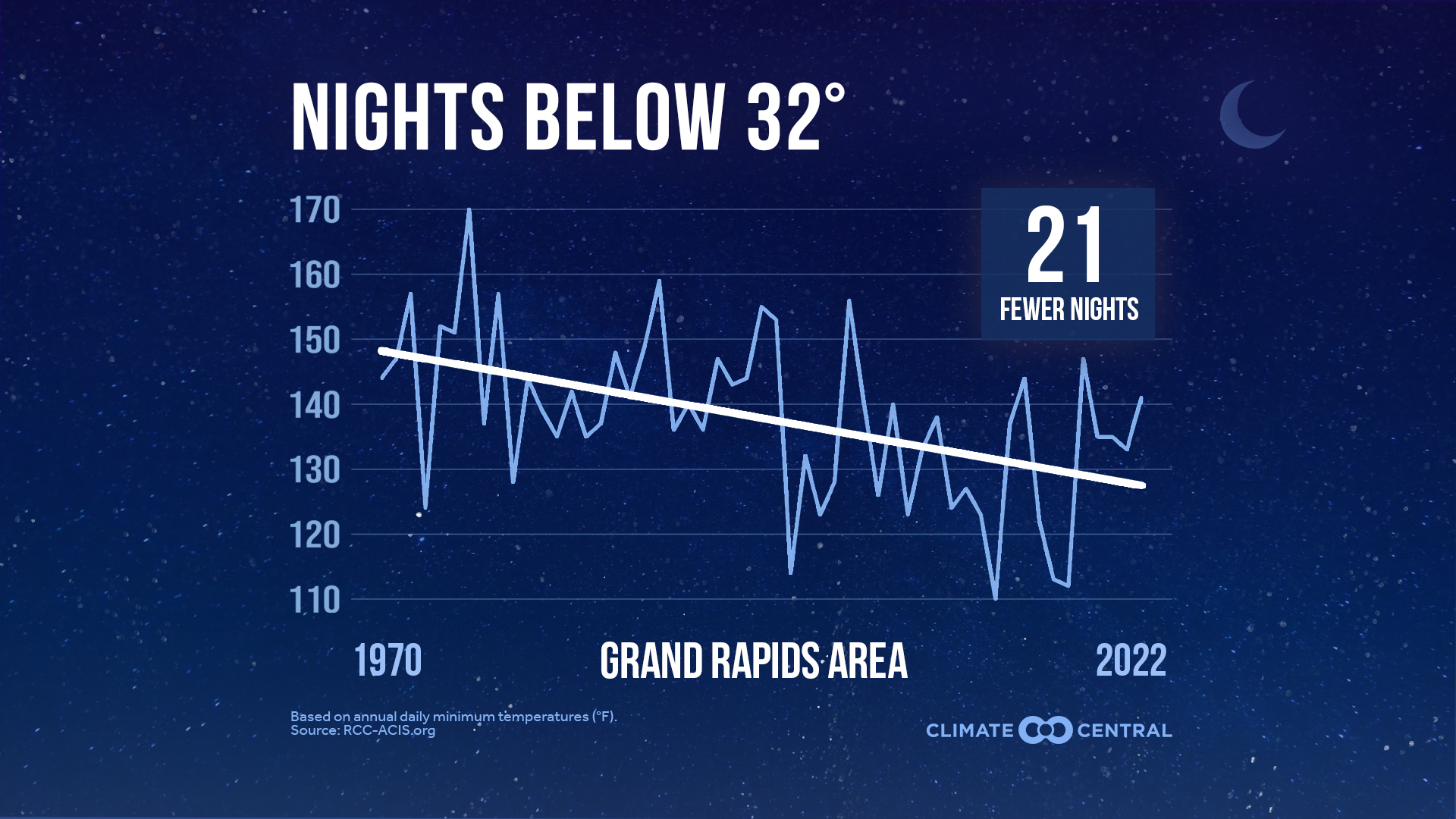
Warmer Winter Nights
The coldest time of year plays an important role in plant, animal, and insect life cycles, recharging snowpack that supplies freshwater, and sustaining snow and ice for winter recreation and associated local economies.
For most of the U.S., the coldest nights of the year are warming.
Climate Central analyzed local trends in the number of coldest nights each year from 1970 to 2022. What is considered a cold night differs from Minneapolis to Miami. Locations were therefore assigned different low-temperature thresholds based on their climatology (see methodology for details).
-
Of the 247 U.S. locations analyzed, 231 had at least one day at or below freezing in at least half the years in the period of analysis.
-
Of these 231 locations, 204 (88%) have experienced a long-term decrease in the annual number of freezing nights since 1970.
-
Of the 204 that have experienced a decrease in freezing nights, the average decrease since 1970 was 13 fewer nights below freezing.
-
The locations that have experienced the largest decreases in the number of nights at or below 32°F were: Reno, Nev. (91 fewer freezing nights); Albuquerque, N.M. (45 fewer freezing nights); and Bend, Ore. (41 fewer freezing nights).
-
Some locations that previously experienced freezing nights during earlier decades now no longer do—including Las Vegas, Nev.; New Orleans, La.; Phoenix, Ariz.; and several locations in California (San Francisco, San Jose, and Santa Maria) and Florida (Fort Myers, Sarasota, Tampa Area, and West Palm Beach).
Cool places and seasons warm quickly
The observed trends since 1970 are part of a longer-term trend.
-
The most rapid warming in the U.S. has generally occurred when and where it’s usually the coldest, including at night, in northern parts of the country—and during winter.
-
Winter was the fastest-warming season for 74% of 246 U.S. locations analyzed by Climate Central.
-
Nationwide, the rate of warming for nighttime lows since 1900 (1.78°F per century) is about 25% faster than the rate of warming for daytime highs (1.42°F per century).
Fewer future freezes
Climate models suggest that the coldest times of the year will continue to warm if emissions of heat-trapping greenhouse gases continue.
-
The Climate Impact Lab modeled future scenarios of the change in annual days below freezing.
-
Under a medium-high emissions scenario, every state in the contiguous U.S. (and Alaska) will experience a drop in days with below-freezing temperatures by 2040.
-
By the middle of the century, 23 states—especially in the Northwest, Southwest, Plains, Upper Midwest, and Northeast—are projected to see at least three or four fewer weeks of freezing days.
Fewer freezes: cold weather hazards
Extreme cold comes with serious risks. During the December 2022 winter storm, more than two-thirds of the U.S. population (those under weather advisories or warnings) experienced these risks. The storm and Arctic front sent temperatures plummeting across the central and eastern U.S., left more than one million people without power, and contributed to an estimated 87 fatalities.
A long-term decrease in the number of freezing days and nights may reduce some of the most acute risks of cold exposure among vulnerable populations, including the hundreds of thousands of people experiencing homelessness in the U.S. Hazardous extreme cold events such as the December 2022 winter storm still occur in a warming climate, however.
As the coldest nights of the year warm, the costs of home heating may also decrease, reducing the economic burden on many families. The total U.S. winter heating degree days have decreased since 1974, along with residential winter natural gas usage.
Fewer freezes: cold weather benefits
Although fewer freezing days and nights can reduce the risks and costs associated with the coldest times of year, these trends can also have negative consequences for economies and ecosystems that depend on the cold.
-
Warming during the coldest time of year can disrupt snowfall patterns, which can in turn limit snow-fed water supplies that people, agriculture, and ecosystems rely on throughout the year.
-
Communities and businesses reliant on winter recreation may find it difficult to maintain snow and ice. That means less ice for ice fishing, fewer cross-country ski days, and shorter snowboarding seasons.
-
A lack of cold can prolong the active season and expand the range for disease-carrying pests such as ticks and mosquitoes. According to the EPA, the increasing number of cases and the growing distribution of Lyme disease are indicators of climate change.
-
Yields of high-value fruit crops that require a minimum number of winter chill hours can also be impacted by a decrease in the number of freezing days and nights.
(citation https://www.climatecentral.org/
Forecast Discussion
- Wintry mix of precipitation today -

A strong low pressure system centered over northeastern Kansas
early this morning will move ene and bring mixed pcpn to our area
today. Pcpn will develop over our far sw fcst area around daybreak
as a result of strong isentropic lift north of the warm front.
Pcpn will then overspread our area from sw to ne through the
morning.

P-type will be predominantly rain near to south of I-96 but a
brief one to two hour period of -fzra and sleet is possible at the
beginning of the event due to dynamical cooling and sfc temps
near freezing.

North of the I-96 corridor we expect freezing rain with potential
for fzra accumulations on the order of a quarter to third of an
inch. The axis of relatively highest fzra accumulations will
likely occur from near KRQB ese to Alma as suggested by the 00Z
HREF FRAM ensemble mean for ice accretion. Some sleet may mix in
at times.

North of a line from KRQB to KMOP there is potential for around 2
to 5 inches of snow. Relatively highest accums within that range
are expected across our far ne fcst area up around Clare. As a
result of this wintry mix of pcpn we expect hazardous travel
conditions to develop today mainly north of I-96.

- Weaker system to bring mixed pcpn late Tue night/Wed -

A system over the north central Plains will move east and bring a
wintry mix of pcpn late Tuesday night into Wednesday. Light snow
accumulations on the order of an inch or two are possible with
this system mainly over our northern fcst area where cooler
thermal profiles will result in mostly snow for p-type.

- Potential for snow Friday -

A strong low pressure system over the Arklatex region Thursday
evening will move ne and potentially bring significant snow to our
region Friday. It is noted that overall medium range guidance
trends the past 24-48 hrs are certainly further nw with that
system.

In fact the 00Z deterministic GFS would bring our area a
snowstorm Friday while the 00Z GEFS is further south with the
system. The 00Z deterministic ECMWF is also far enough south to
keep heaviest snow south of our area. Nevertheless model trends
with this system will be monitored very closely as it has the
potential to a significant winter storm for portions of our area.
Mookie said no snow this week and Barry said Spring is here! How wrong could they be? Get ready for a March snowstorm! I love long winters with above average snowfall! Get ready to rock!
Get ready for the SNOWSTORM!!!!!!
This very well could go down as one of my top 5 favorite winters. Crazy up and down shifts, when is snows it snows a lot it seems. Ice events, thunderstorms and thundersnow today. . Literally a winter that offered something for everyone
A wild and very snowy winter, highlighted with a blizzard warning! Wow just wow!
Is winter dead? Is Spring here? No those are delusional fantasies! The impending snowstorm is looking good!
https://weather.com/storms/winter/news/2023-02-27-winter-storm-quest-california-midwest-northeast
Check out the modles for Friday looking good for more snow enough to alert Winter storm watches in March great Scotty Winter must still be here!!!!!!!!!! INDY
Who knew?
Northern lights are very active right now with a possible G-3 storm in the next day or 2. That would pretty much guarantee they will be this far South.
https://spaceweather.com/
Yet another record breaking rainfall total today. Or maybe the NWS is now delusional as well?
https://forecast.weather.gov/product.php?site=GRR&issuedby=GRR&product=CLI&format=CI&version=1&glossary=0
I don’t think anyone is thinking the NWS is delusional for todays data???
Rock on Kyle and yes it rained today, but GR is still nearly 20 inches above normal for snowfall and a pending snowstorm is in the cards for this week! Wow, what a winter!
It would be quite something if it panned out. Time will tell.
We have lots of trees down now, but the power is back on. I just went and measured the ice, there is about 3/8”. And the wind has picked up a bit, so it’s raining ice chunks.
For the latest Consumers outage map:
https://www.consumersenergy.com/outagemap
Maybe the worst is over?…now it’s clearly, “watch for falling ice from trees”
Breaking Winter Weather BULLETIN>>>>>>the latest EURO shows lower Mi getting hammered with accumulating snow this Friday! How could it be? Mookie said no snow is in the forecast and winter is over and Barry said Spring is here? The delusion is incredible and happens every year! Keep winter rocking till April!
Interesting to note the Euro and Canadian are more on the same page. The GFS shows a wider range of precip types but appears to be the outlier according to NWS GR. The Euro is printing out 6-12” across parts of southern Lower MI. Whether or not that is overdone I’m not sure. Definitely something that needs to be watched closely.
Bring on the snowstorm! We have a a lot of winter weather left this season! Who would have thought?
Lol… Great night to be heading to Florida Friday during another Snowstorm… Going to have to leave early…Stay warm INDY
Give me a snowstorm over FL any day!
My wife just noticed that all of the sudden there’s a pack of about 40 robins in our back yard. Must have just flown up from down South knowing that Spring is here!
🙂 I have seen some too.
According to the SPC, there was a brief tornado touchdown just outside of Warrenville, IL. Dude, that’s like 15 miles from our baby girl’s school.
Rain still coming down at a pretty good clip. We have standing water out back. Still a little bit of ice on the branches – about the same amount during our “Ice Storm Warning.” 35 here currently.
We are getting a lot of rain. I feel like we are in an island. Lol.
Sheesh, it hasn’t stopped raining and it’s pouring now.
How’s the icing in Grand Rapids? I’ll be headed that way in a couple hours from Kzoo
The roads should be ok. There was a lot of rain here with temperatures around 31 to 33 there is some soft ice on the car windows. Here in my area there is still snow/ice on the ground. The temperatue here is now at 33 but the rain looks to soon be ending
Slim
Power outages in our area are starting to pop up! We need it to warm up and switch to plain rain soon!
Quite a few outages, especially just NW of Grand Rapids
looks to be more so to the NE of Grand Rapids
Slim
That’s what I meant, thanks 😀
The National Weather Service in Northern Indiana has issued a * Tornado Warning for… Southern La Porte County in northwestern Indiana… * Until noon CST. * At 1111 AM CST, a severe thunderstorm capable of producing a tornado was located over La Crosse, or 11 miles northeast of Wheatfield, moving northeast at 25 mph. HAZARD…Tornado. SOURCE…Radar indicated rotation. IMPACT…Flying debris will be dangerous to those caught without shelter. Mobile homes will be damaged or destroyed. Damage to roofs, windows, and vehicles will occur. Tree damage is likely. * This dangerous storm will be near… Wanatah around 1225 PM EST. Kingsford… Read more »
In northern Indiana? That’s just crazy.
ADA – Starting to lose branches from trees. And so it begins 🙁
It was great winter weather for snowshoeing this past weekend and snow country will be awesome for skiing this weekend! Wow just wow! Winter sports galore this year! Keep it going till April!!!
And if it doesn’t stop raining soon you can add kayaking and swimming as well.
We are getting thunder snow now. Pretty rare.
Scattered power outages are popping up. Also mPING has a report of downed tree limbs. It seems (I might be wrong) that roads are wet but trees/wires are accumulating ice. I’d definitely drive slow just in case
In a matter of minutes we have accumulated lots of ice. Fencing, wires, bushes are sagging. Easily more than they called for all day. Not looking good.
Same here. It’s been pouring here for the past two hours. Ice has been forming over the past 30-45 minutes. The WWA here is set to expire in eight minutes. I’m surprised the NWS hasn’t extended it.
Yah. We are still getting lots of ice. Trees are sagging badly. Way worse than the storm warning last week. I would argue this is in the realm of an ice storm warning at this rate. We have at least a 1/4 of ice and likely a lot more. 5” icicles hanging from branches. CMU main campus just closed too.
And we just lost power for the first time in 5 years.
I mentioned previously that our daughter goes to school west of Chicago. She texted us and said they had a tornado warning briefly as short time ago. Sirens and everything. She’s like, what the heck? It’s February!
Wow!! That’s crazy!!
Still getting “heavy freezing rain” reported here. Very unpleasant out today!
It has been a great winter for skiing and snowshoeing baby! Facts are facts!
Nasty out there, Have at least 2 10ths of an inch of freezing rain on the bushes outside at work here in Kentwood.
I have been skiing and snowshoeing for weeks on end! Granted some of this has been up in snow country, but it has been awesome! Who knew?
It’s been one of the worst years for skiing and ice fishing that I can recall. Lots of warm days melting the snow and lots of rain too. My coworker’s kid is a part of the Friday ski school and they have only been able to ski twice out of the last 6 or 7 Fridays.
Boy, we are getting t lot of rain! Just came back from Hudsonville and parts of Chicago Drive are now underwater. I think they should be putting out flood warnings.
What a winter! Storm after storm! GR has seen multiple heavy snow events and is well above normal for snowfall and more snowstorms are on the way! This will end up as a big time winter! Who would have thought with all the warm weather hype on here? Incredible!
I think you mean one of the warmest winters on record, hardly ever any big snow on the ground, and one of the weakest winters on record according to AWSSI.
Pretty significant icing occurring here. Everything is covered in a layer of ice… hoping it warms real soon. No outages reported so far
It had better begin warming in Ada. Three + inch icicles on the deck. Everything is coated. Bad times 🙁
Agreed this could be trouble!
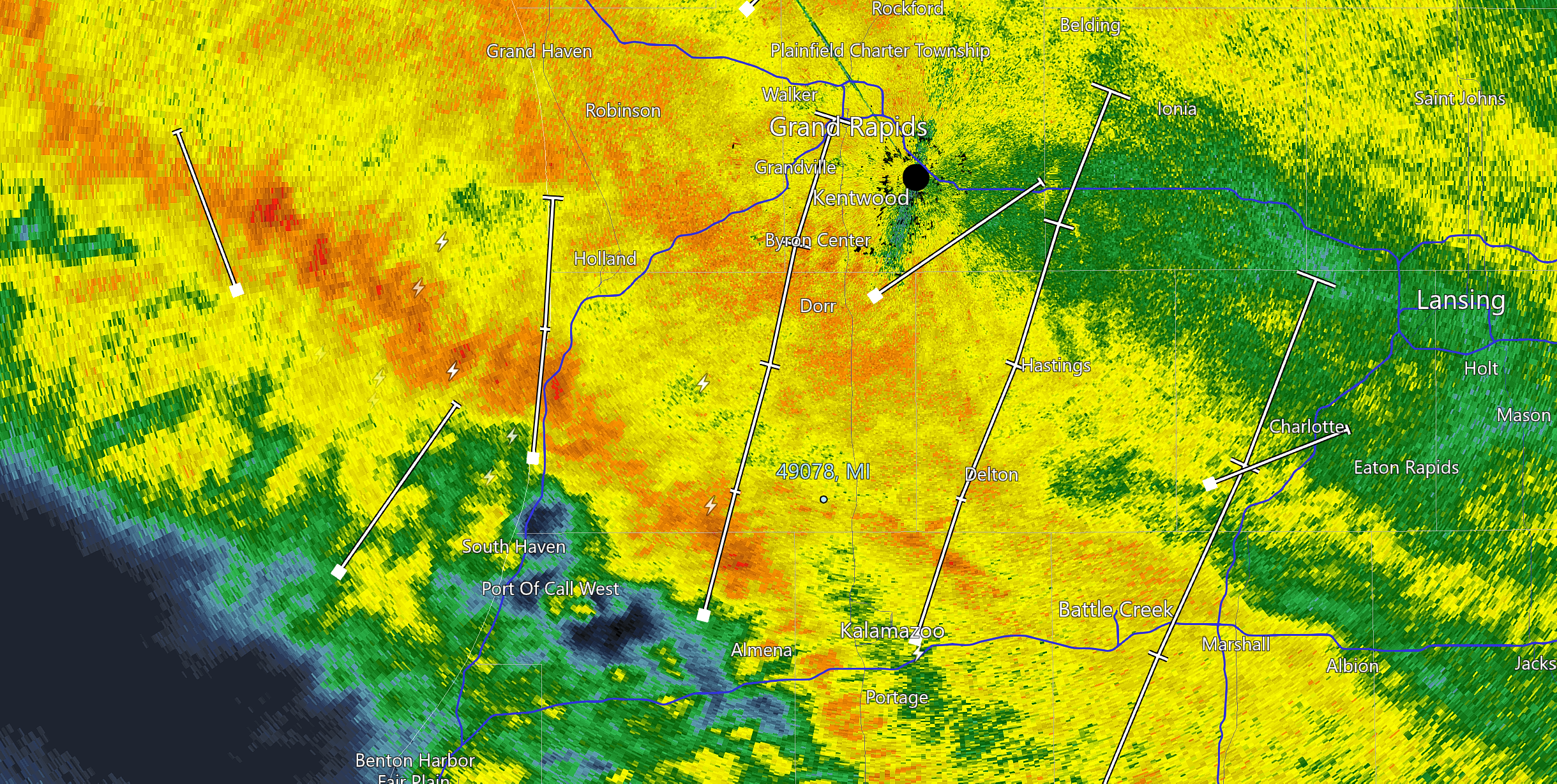
My Current Radarscope image of a line of storms moving through – note the lightning.
Quite a bit of freezing rain accumulating on the trees here in south GR. We are lucky we are climbing above freezing.
We just had a rumble of thunder.
Lightning just a minute ago too.
Seeing some thunderstorms in West Michigan now. Wow!
having some thunder in Otsego now
Ha I just posted that too!!!
WOOD has 44 degrees tomorrow and 46 Wednesday. In fact, every day in their 8 day forecast is above freezing.
This has been the trend all winter. Basically all warm/mild days with a few significant snow events. So we have had 86″ of snow, but one of the warmest winters on record
I think we will see more winters like this past one going forward with climate change only getting worse. Warm winters with lots of lake effect due to the warm lake. Outside of lake effect areas, very little snow.
Ah more early spring rain to melt any leftover snow! Can you believe GR has not received 2″ or more of snowfall for a month? Winter has been dying for a long time now.
I’ve used my snow blower 3 times this Winter. Twice during the Christmas time mini blizzard, and once in late January. It’s spent most of 4 months just sitting unused in a corner of the garage.
This past winter reminds me of a Denver winter. We got some snow, but it would quickly melt every time.
I only used my snowblower once this season.
Great post. I find it hard to believe there are some people that refuse to believe we are in a long term climate warming trend. The data is irrefutable.
People believe in total bunk conspiracies, so no surprise they don’t believe in global warming! Unfortunately a lot of totally ignorant hateful people out there!
Nice post, MV. It’s nice to see data to support what most of us already knew what has been happening. California has been inundated with precipitation lately. A quick glance at the reservoir levels has shown a dramatic increase, which is fantastic. I believe I read somewhere that 1/3 (?) of US agriculture comes from California’s central valley.
I’m looking forward to the rain today so Mother Nature can give me a free car wash and remove the salt and grime. Have a great day everyone, and make someone smile. 🙂
Even some lightning just across the lake this morning.
https://www.lightningmaps.org/#m=oss;t=3;s=0;o=0;b=;ts=0;z=8;y=41.9876;x=-87.4867;d=2;dl=2;dc=0;
Currently pure rain and 32 here. Thankfully we are supposed to warm above freezing within an hour or two
Good read on the warming Winter nights. GR now has 21 fewer nights below freezing? Wow, that’s getting close to an entire month!
Been all rain here again this morning. It started out just below freezing, now the temps up to 35 so that should terminate any ice left around the yard. It would be really interesting to know just how many days of rain we have had this Winter.
That radar is very colorful this morning!!!
Nice write up on how the winter season is changing. I wonder how that has impacted the warm/summer season?
Slim
There is a area of moderate to maybe heavy sleet just to the SW of Grand Rapids at the current time. The temperature here at my house is now 31 but that is up from the overnight low of 23. The official H/L at Grand Rapids yesterday was 40/24. There was no rain or snow fall as the sun was out a total of 660 minutes and that is good for 99% of possible sunshine. There was 1” of snow/ice on the ground. And in my yard there is still around a 1 of snow/ice on the ground this AM.… Read more »
what is with the NWS? about 5 daus ago (according to Terry DeBore), the outlook for March was to be warmer than everage, and then this weekend, NWS says that the next three to four weeks look to be colder than average?
Thanks mookie for saying no snow is in the forecast and winter is dead! That means get ready for more storms! Winter is far from over! More accumulating snow this week and beyond! Get prepared now! Cold and snow rocks!