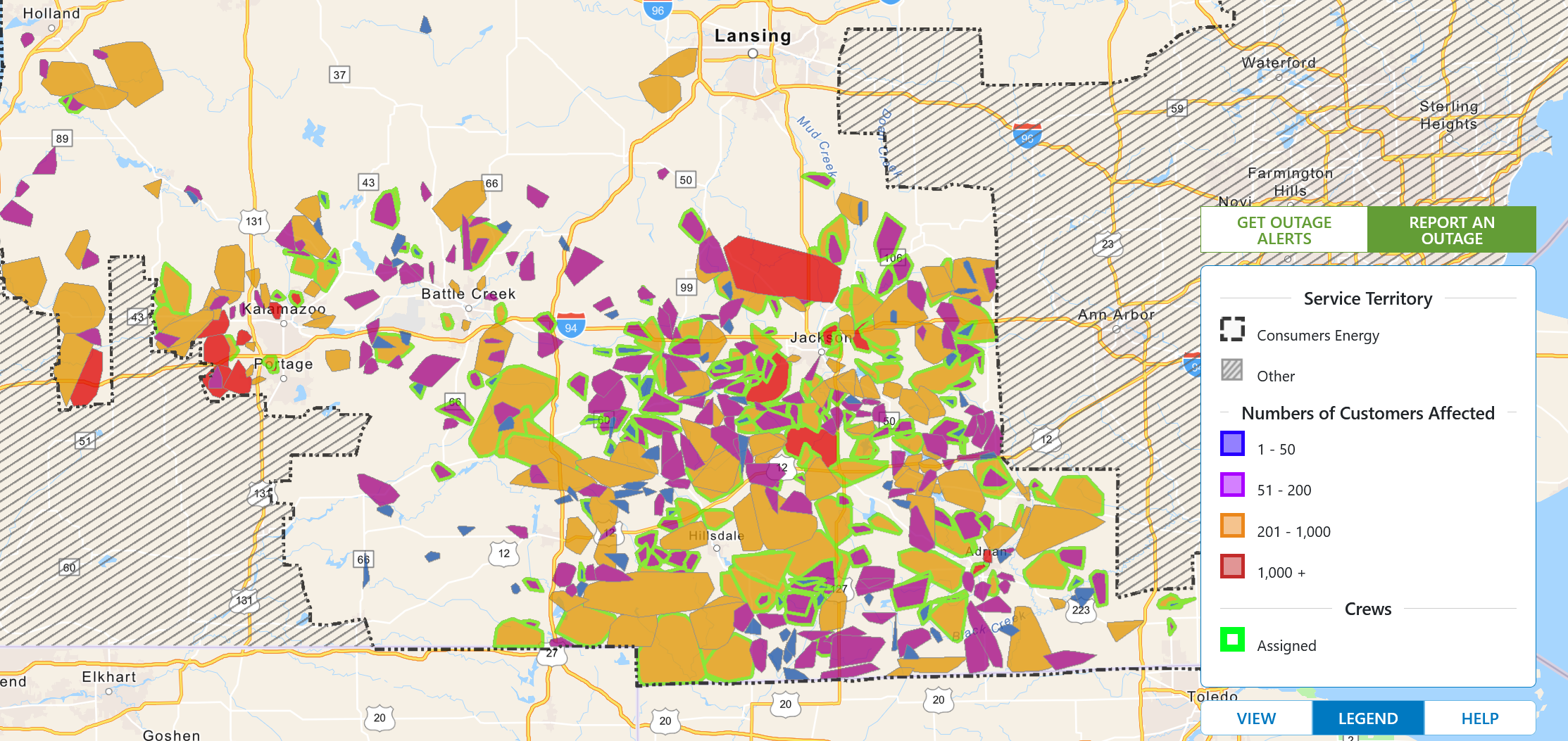
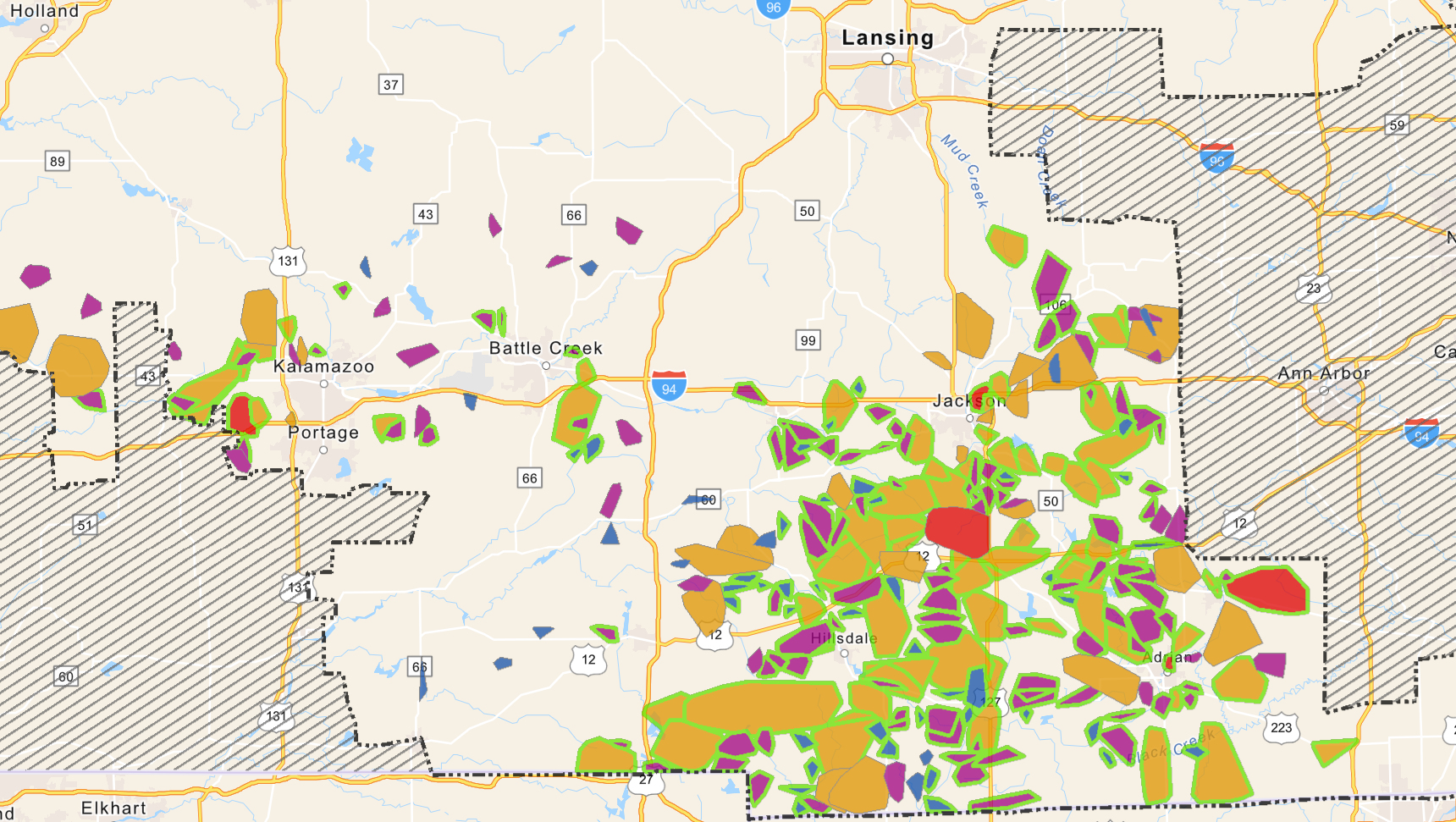
Hats off and a big cheer to the Consumer power crews working the lines to get power back on in southern Michigan, below are the comparisons from the 24th to this morning.
Look for decreasing clouds this morning, followed by sunshine A wintry mix of freezing rain, sleet, snow, and ordinary rain will arrive on Monday, likely causing slippery travel in many areas. Ice accumulations are most favored north of I-96. A few power outages are possible if/where any localized heavier freezing rain occurs. This event shouldn’t be as bad as last week’s event with the exception of heavy rain moving in where some areas may receive over an inch of it.
Grand Rapids Forecast
2 26 grrLansing Forecast
2 26 lanKalamazoo Forecast
2 26 kzoForecast Discussion
- Wintry mix of precipitation Monday -

A strong low pressure system moving east from the central Plains
states will bring a mix of pcpn beginning early to mid Monday
morning as strong isentropic lift develops ahead of the low. Pcpn
will likely struggle to develop initially due the dry easterly
winds with the high pressure ridge to the ne of our region.

Precipitation type will be predominantly rain south of I-96 but a
brief period of fzra and sleet is possible at the onset of pcpn
with sfc temps near freezing and due to dynamical cooling effects.
This notion is also suggested by the 00Z HREF.

Near to mainly just north of the I-96 corridor we expect a swath
of freezing rain with potential for fzra accumulations on the
order of a quarter to third of an inch. We have included the I-96
corridor in the fzra threat area since some of our latest high res
guidance and 00Z HREF has trended a bit further south with the
fzra potential. The potential for significant fzra accumulations
will likely be mitigated somewhat by potential for a fair amount
of sleet to mix in as suggested by the HREF.

Further north mainly near to north of a line from KRQB to KMOP
there is potential for around 3 to 6 inches of snow. Strong winds
are fcst on the back side of this departing system Monday night.
At this time this looks a little more like a high end advisory
rather than warning event with the most significant impacts coming
from late morning through the afternoon mostly north of I-96.

- Much weaker system to bring mixed precipitation midweek -

A fast moving system moving east from the northern Plains will
bring rain showers to most of our area Wednesday with a wintry mix
of pcpn possible north of the I-96 corridor. It will turn colder
behind that system with high temps by Friday only expected to
reach the 30s.
Looking good and let’s keep, winter rocking till April! Rock n roll will never die!
https://www.pivotalweather.com/model.php?p=snku_acc-imp&rh=2023022618&fh=384
…. As some are gasping for a mildly week we have another Winter weather advisory out for the end of February I will gasp on that ….INDY
I love it, every time mookie says no snow in sight or winter is dead we get more winter weather! Wow to the wow!
Let it melt, let it melt!
Our WWA is for only five hours tomorrow. That’s a pretty short period of time. Back in my day (cue my kids’ eye rolls), this would have been a Travelers Advisory.
Are you a dinosaur too, Mark? Lol. I thought the same thing about my parents. It sure makes you feel old. Lol
My favorite thing my mom told me is just wait until your music is used in your kids music. Lol. Ugh…mom right again. Lol
…WINTER WEATHER ADVISORY IN EFFECT FROM 9 AM TO 8 PM EST
MONDAY…
* WHAT…Mixed precipitation expected. Total snow accumulations
of 1 to 3 inches and ice accumulations of up to two tenths of
an inch.
* WHERE…Lake, Newaygo, Mecosta, Isabella, Montcalm and Gratiot
counties.
* WHEN…From 9 AM to 8 PM EST Monday.
* IMPACTS…Plan on slippery road conditions. The hazardous
conditions could impact the evening commute.
…WINTER WEATHER ADVISORY IN EFFECT FROM 7 AM TO 3 PM EST
MONDAY…
* WHAT…Mixed precipitation expected. Total snow accumulations of
up to one inch and ice accumulations of around a tenth of an
inch. Winds gusting as high as 35 mph.
* WHERE…Ottawa, Kent, Ionia and Clinton counties.
* WHEN…From 7 AM to 3 PM EST Monday.
* IMPACTS…Plan on slippery road conditions. The hazardous
conditions could impact the morning commute.
Still no big snow in sight! This week looks nice and mild.
We still have several inches of snow on the ground. And I hope we add to it on Monday, but it’s not looking good. It appears we are in the bullseye for ice. There hasn’t been any watches or warnings issued yet. Which is a bit strange or maybe an indication of uncertainty.
NWS Grand Rapids in their morning discussion says there could be sleet mixed in and expect it to be a high end advisory type of event
There is still a good inch or more of snow/ice on the ground here in NW GR. The official H/L low for yesterday was 32/23 there was 0.02” of precipitation that was 0.7” of snow fall. For the season Grand Rapids is now up to 86.8” of total snow fall. The overnight low here in my yard was 25 and at the current time with clear skies it is 28. For today the average H/L is 37/22 the record high of 64 was set in 1944 and the record low of -9 was set in 1963 the record snow fall… Read more »
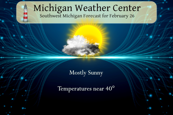
40 and sunny today. It’s going to be a nice day for a walk. 52 on Wednesday to usher in meteorological spring. That’s like an April 1st high, not a March 1st high.
Like Rocky says, get outside and enjoy the day. It’s time to shake off those winter blues. And remember, make someone smile. 😀
Great winter day! I will be snowshoeing and enjoying the snow and sun! Wow just wow!
The snow just keeps coming! GR is now up to nearly 87 inches! More cold and snow is in the forecast! March looks cold and snowy! Get ready to rock! Wow to the wow