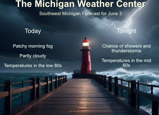
We ended up with 73° for a high temperature yesterday when we finally had the sun break through the clouds in the afternoon. We begin today with fog around the area and temperatures in the low to mid-50s. We expect the sun to make an appearance as the fog burns off, and temperatures will warm up to the low 80s. Tonight our chances of rain and storms increase.
SPC Outlook

Rainfall Totals

NWS Forecast
Weather History
1945: An early June cold spell brought widespread frost and freezing temperatures from June 3rd to the 5th. The temperature bottomed out at 32 degrees at Grand Rapids on the morning of the 4th, a record for the coldest June temperature and the latest freeze.
On June 3, 2007, the remnants of Tropical Storm Barry combined with an upper low pressure produced widespread heavy rainfall. The heaviest rain fell over southwest Livingston County with estimates of up to 5 inches. This caused some flooded roads and raised lake levels on the many lakes in that area, threatening local property.
Also on June 3, 1973, two F0 tornadoes hit Genesee County between 5:15 and 5:30 PM, but only caused about $3,000 in damage.
1860: Iowa’s infamous Camanche Tornado, likely an F5 storm, kills 92 and injures 200. Every home and business was destroyed. It was one of the most damaging families of tornadoes to strike the US. It resulted in more farm fatalities than any other tornado except for the Tri-State tornado.
1921: Heavy rains caused flash flooding over the southeastern portion of Colorado. The flooding cost the lives of 100 people and millions of dollars in property damage. Click HERE for more information from the History Channel.
1993: Early morning severe thunderstorms dumped huge hailstones across northern Oklahoma. Hail, up to 6 inches in diameter in Enid, went through roofs of homes, damaged three jets at Vance Air Force Base, and did $500,000 in damage at a car dealership. Winds gusts reached 70 mph at Vance Air Force Base as well. Hail damage to the wheat crop was estimated at 70 million dollars.
1997: It was a chilly day in the East. The high temperature at Philadelphia International Airport was only 59 degrees, tying a record-low maximum for the date set back in 1881. The temperature at Middletown, Pennsylvania rose to 58 degrees, breaking the record-low maximum for the date of 59 degrees in 1915. Washington, DC only reached 58 degrees, breaking the old record-low maximum of 59 in 1915. Central Park in New York City only reached 61 degrees.
Forecast Discussion
- Morning Fog, Warm and Rain-Free Daytime, Chance Storm Tonight

Airport observations, webcams, and nighttime microphysics satellite
imagery indicate regions of fog in a few different parts of the
area, and variable visibilities within those regions including
occasional dips to a quarter mile. Fog should mix out over land by 8
or 9 AM with a fair amount of sunshine today.

Keeping the forecast rain-free until after 7 or 8 PM based on the
00Z HREF, which is slightly later with the timing than the previous
12Z run. Convection from Iowa to Wisconsin and northern Illinois
today will struggle to make it into Michigan with slight ridge
amplification over the eastern Great Lakes and a lack of upper-level
jet support. Somewhat better dynamics and 850-700 mb moisture
advection arriving after 8 PM will provide better chances of a
thunderstorms from Wisconsin being maintained, especially northwest
of Grand Rapids. CAPE less than 500 J/kg would be a limiting factor
especially with eastward extent. Each model within the HREF has its
own take on the decay of the Wisconsin convection over Michigan
tonight, so confidence in the details is low.

- Medium/High Confidence in evolution of upper troughing this week

There remains good agreement among model solutions with the closed
upper low approaching from the northwest this week. This low figures
in the evolution of persistent troughing across the Great Lakes by
the end of the week with lower 500 mb heights and low level
northwest flow indicating cooler than normal temperatures into early
next week.

As far as rain chances,Tuesday will see some showers and
thunderstorms in moist southerly flow ahead of the upper low with
the best chances on Wednesday as a cold front will focus rain and
embedded thunderstorms. Deep layer shear is progged to be 25 to 30
knots on Wednesday afternoon so some organized convection is
possible, although severe storm threat appears low.

The upper low will bring showery and seasonably cool weather for
several days from late week into early next week.
What do you know? The latest CPC has us locked into below normal temps despite the constant warm weather hype! Some things never change!
While out walking this morning… I am beginning to feel more concerned that our fall colors will look like with the “spongy moths” aka gypsy moth have eaten. When we walk I feel like Godzilla trying to squash the caterpillars as they make their way to more trees.
This darn caterpillars have caused me to have reactions from their hairs. I had a bunch of welts from the babies and now have a few from the adult caterpillars that get on me when mowing.
Our oak trees sadly looking very bare on our road.
I know what you’re saying. They are EVERYWHERE.
What do you know, June is starting out warm too!
Very foggy early this morning, but it was mostly gone before 7a. It’s another pretty morning. Clear skies, no wind, and lots of birds chirping. It looks like I may need to shut the windows and use the A/C again. Have a great day, friends.
The overnight low here in MBY was 55 and at the current time it is clear on 60.
Slim
The official H/L yesterday at Grand Rapids was 77/59 there was 0.04” of rainfall. The sun was out 28% of the time. For today the average H/L is 76/55 the record high of 96 was set in 1934 the record low of 38 was set in 1947, 1977 and 1986. The record rainfall of 1.76” fell in 1892. Last year the H//L was 90/62 in the last of a early season heat wave.
Slim
Nice rain on Saturday, it started coming down as I finished packing up at the Holland Farmers Market. Tomorrow looks summerish, but short lived (yay!). Not quite ready for muggy weather yet. Have a good week everyone.