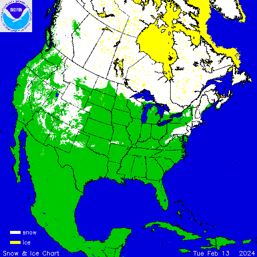
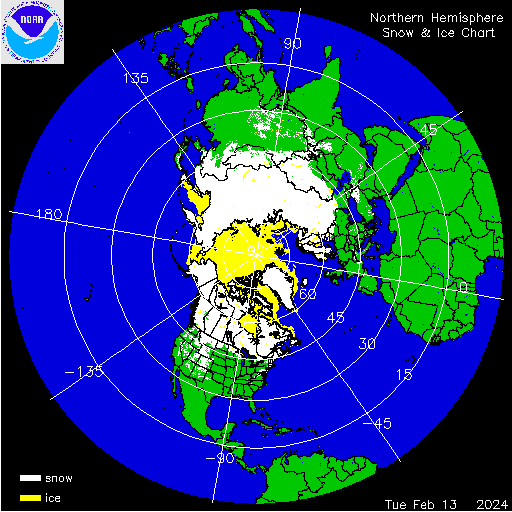
First I would like to present the current ice and snow cover maps for the northern hemisphere, most of the snow is contained above the 45th latitude except in the Rocky Mountain area, the extreme northern CONUS, and the northeastern seaboard (from yesterdays snowstorm)
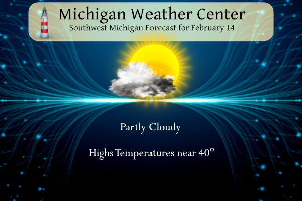
Today will be mostly sunny to partly cloudy and dry with highs in the upper 30s to near 40°. Things will be dramatically different on Thursday however. A quick-hitting snowfall is likely Thursday morning. Areas near and north of I-96, up through Central Michigan, have the greatest chance of 2 to 4-inch accumulations of wet snow. A brief mix or cold rain is more likely in southern Michigan. This should move out by early afternoon.
NWS Forecast
Weather History
1899: The record arctic cold wave begins to abate but not before Grand Rapids sets their all-time record low of 24 below zero.
On February 14, 1905, a very cold Valentine’s Day night was experienced in Detroit, with the temperature plummeting to -15 degrees!
Also on February 14, 2007, a two-day snowstorm ended leaving most of Metro Detroit with 6 to 8 inches of new snow. There was also considerable blowing and drifting of the snow with drifts reported as high as 2 to 4 feet in some locations.
1895: The most significant snowfall in the history of Houston, Texas, occurred on the 14th and 15th. The Houston area saw 20 inches of snow. Click HERE for more information from Space City Weather.

1940: A St. Valentine’s Day Blizzard blankets New England with up to 18 inches of snow. Gale force winds associated with the storm strand many in downtown Boston.
1982: A “meteorological bomb” exploded in the Atlantic southeast of Newfoundland. The term is used to describe a storm that rapidly intensifies. The intense cyclone off the Atlantic coast capsized a drilling rig killing 84 persons and sank a Soviet freighter resulting in 33 more deaths. The cyclone produced 80 mph winds that whipped the water into waves fifty feet high.

The weather map above is from February 14th, 1982. In the upper right, you can see a tight pressure gradient, which indicates very strong winds. The 80 mph winds and center of 972 mb are equal to a category 1 hurricane.
1990: Valentine’s Day was a snowy one for many parts of Iowa and Illinois. Five to ten inches of snow fell across Iowa. Six to 12 inches of snow blanketed northern Illinois, and strong northeasterly winds accompanied the heavy snow. Air traffic came to a halt during the evening at O’Hare Airport in Chicago, where 9.7 inches of snow was reported. More than 250 traffic accidents were reported around Des Moines, Iowa, during the evening rush hour. In addition, an ice storm glazed east central sections of Illinois, causing twelve million dollars in damage in Champaign County alone.
2007: Light snow fell on Nepal’s capital, Kathmandu, for the first time in over 60 years. They also saw light snow on February 28th, 2019.
2010: Vancouver struggled with above-average, non-winter-like temperatures during the first weekend of the 2010 Winter Olympics. In fact, Vancouver was warmer, 48 degrees, than Miami, Florida, 45 degrees!
Forecast Discussion
- Briefly Heavy Accumulating Snow Thursday Morning

In coordination with DTX, bumped snowfall amounts upward relative
to what most guidance has provided. Our best guess, as things
stand now, is that the region just north of Lansing (including
the Saint Johns and Alma areas) could experience the most
intense snowfall, exceeding an inch per hour for a couple hours
or more and occurring around or shortly after 8 am. Please note
that the specificity of this scenario should not be confused
with forecast confidence. While we are reasonably certain that
the character of this event will play out along these general
lines, questions remain about the exact timing and placement of
heaviest snow. For reasons I`ll explain below, it`s probable
that there will be a substantial north to south gradient of
snow amounts, so this forecast is particularly sensitive to
placement.

As noted in the previous discussion, snow production will
depend on the low level thermal profile extending farther south
towards the I-94 corridor. It also will depend on how the mid-
level forcing and response evolve. In terms of forcing, we
expect mid- level fgen to be realized through pivoting/buckling
of the thermal gradient. The response should be strong and
narrow as there are indications of mid-level conditional
instability, via negative EPV, that will juxtapose with the
forcing region. This is why snowfall rates could be quite large
- but again, there could also be a substantial north to south
gradient in snow accumulation due to both warmer temperatures to
the south and the narrowness of the fgen response.


- Colder with Snow Showers Friday into Saturday

No real changes to previous thinking. A rather impressive upper
trough drops southeast into the western Great Lakes. As noted
before, we can expect a deepening of mixing layer heights ahead
of this feature. The best signal for lake effect looks to be
prior to 12Z Saturday when decreasing theta-e with respect to
height in the 0-2km layer suggests the depth of lake induced
conditional instability will be most pronounced. Lake effect
snow may be at maximum intensity in the 8 pm to midnight
timeframe on Friday when elevated CAPE will be well aligned
with the DGZ.
We are getting blasted with Snow! So much for those that said mainly rain! More delusions down the drain!
Let it snow, let it snow, let it snow!
Look at all of this snow coming in the lower 48, yet they keep saying winter is over! What a joke and total delusion!
https://www.pivotalweather.com/model.php?p=snku_acc-imp&rh=2024021418&fh=384
Breaking weather news>>>>>>we have plenty of winter weather to come! It could be a wild late winter! Get ready!
What? Another WWA! The warm weather nuts declared winter dead about 2 months ago! How wrong can they be? Incredible!
lol!!! Cold weather crazies are grasping at overnight lows now! Funny thing is highs over the next couple weeks are going to be in the low to mid 40’s! I’ll take temps in the teens and twenties while I’m sleeping!!! LLOLOOL!!
https://weather.com/weather/tenday/l/52aab230ef88e4f2bb12857231a5dd58392e78a71b90e01d57a11d827658eb55
Get ready for low temps in the teens! Wow, now that is some COLD air!
CPC has us switching back to mild temps again upcoming! So much for the big cold and snow the second half of February. Whoops!
Check it out today now Mookie! May need a BLOWTORCH WATCH! With spring right around the corner, not looking too good for old man winter!
Who is ready for a snowstorm and cold weather? Rock n roll baby!
The 14 day is looking great! Only a couple cooler days showing up.
https://weather.com/weather/tenday/l/52aab230ef88e4f2bb12857231a5dd58392e78a71b90e01d57a11d827658eb55
Great that shows every night below freezing, so plenty of snow chances! I love it!
Yep and plenty of highs in the 40’s so no accumulating snow! I love it!
According to the current GFS map. Looks like the low goes over Newaygo County. If that is the case, could be mostly rain tomorrow for this area. Either way, this is just a quick hitter and it’s back to the 40’s Monday.
Happy Valentines Day, friends! It was a good turnout at Mass this morning for Ash Wednesday. Have a great day!
Happy Love Day… that’s what our kiddos used to call it. Lol
What? Winter is not cancelled? Incredible!
The official H/L yesterday was 37/23 there was a trace of snowfall. The total for the month is now a trace. For today the average H/L is 33/19 the record high of 54 was set in 2023 the record low of -24 was set in 1899. The most rainfall of 0.90” fell in 1911 the most snowfall of 7.8” fell in 1946 the most on the ground was 21” in 1985 and 1936. Last year there was the record H of 54 and the low was 26.
Slim