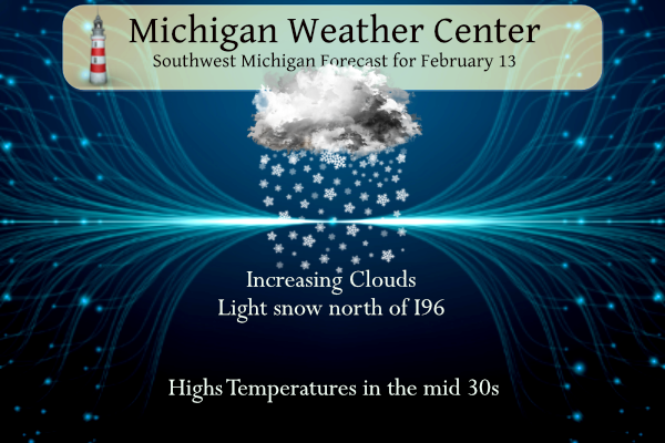
There is a chance of some light snow north of I96 today other than that our snow drought continues thanks to the strong El Nino in place. Great Lake ice cover is only around 2% of normal for February. The CPC predicts ENSO neutral conditions in the April to June timeframe and La Nina developing over the summer. Will this lead to cooler, wetter conditions for Michigan? I am not one for long-range guesses so we shall have to wait and see how this all plays out.
NWS Forecast
Weather History
1938: Heavy rain and warm temperatures prevail for the second day. Lansing records over three inches of rain from the storm and Grand Rapids over two inches and some minor flooding is noted across Lower Michigan.
On February 13, 2022, convective snow showers impacted Metro Detroit during the late afternoon to early evening. Snowfall rates in excess of an inch per hour were observed and some locations around Livonia received 6 inches of snow in total. This snowfall led to numerous accidents and the closing of several stretches of interstate highways.
On February 13, 2015, Flint set a daily record low of -8 degrees. This broke the old record of -7 which occurred in both 1970 and 1958.
Also on February 13, 1894, a two-day snowstorm dropped 12.8 inches of snowfall on Detroit.
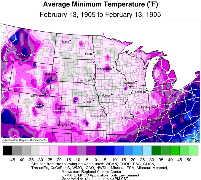
1905: Freezing temperatures were recorded over the states of Oklahoma, Arkansas, Kansas, and Missouri. Morning lows of 29 degrees below zero at Gravette, Arkansas, 40 below at Lebanon, Kansas, and 40 below at Warsaw, Missouri, established all-time records for those three states.
The low temperature at Vinita, Oklahoma, plummeted to 27 degrees below zero. The temperature would be tied at Watts in January 1930 and Blackwell and Medford in February 2011. The negative 27-degree reading is cold enough to be the 2nd lowest temperature on record in Oklahoma. The coldest is currently 31 degrees below zero, recorded at Nowata on February 10, 2011.
1995: A National Weather Service Survey Team concluded a weak (F1) tornado occurred at the General Motors Desert Proving Grounds facility in Mesa, Arizona. Moderate damage was observed. A roof was damaged, and about 20 vehicles were destroyed and moved around. One car was lifted, moved several feet, and set down inside a roped-off area containing solar exposure equipment. The tornado traveled northeast and lasted about five minutes. The image below is from the February 1995 Storm Data.

2000: Late in the day and into the early morning hours of the 14th, severe thunderstorms spawned six tornadoes over southwestern Georgia that killed 19, injured 202, and caused $35 million in damages. An F3 tornado hit southern Camilla, killing 11 people and wounding 175 others in the town.
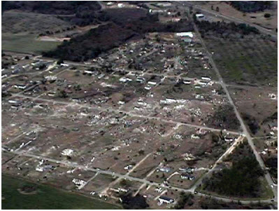
Above is an areal view is of a mobile home park destroyed by the F3 tornado in Mitchell County, just south of Camilla, Georgia.

Forecast Discussion
- Flurries in spots this morning and increasing clouds

APX radar and even MRMS radar mosaics indicate an area of light
snow over northwest Lower Michigan ahead of an upper shortwave
dropping southeast towards the region. Accumulations are not
expected, but did increase coverage of flurries near the
lakeshore and mainly north of I-96. Clouds associated with this
precipitation will spread southeast during the day.

- Snow likely Thursday with locally higher accumulations

After coordination with DTX have bumped snow amounts upward
Thursday for the I-96 corridor region east of Grand Rapids. This
is because there is a growing likelihood for mesoscale banding
associated with mid-level frontogenesis (fgen). Much of this
would occur after the Thursday morning commute, so the
risk/impact factor is not expected to be overly great. Pinning
down exact locations of fgen bands is challenging, but we will
have a growing number of CAM model options to assist with this
effort as our forecast projection time continues to shrink.

- Lake effect snow showers late Thursday into Friday

Accumulations are not expected to be significant during this
time. A signal for lake induced conditional instability appears
Thursday afternoon in the immediate wake of the synoptic snow
and persists into early nighttime. By Friday, colder 850 mb
temperatures notably below -10 C will help with static destabilization,
but it`s unclear how much moisture will be present to assist
with snow production. Some guidance such as the Canadian suggests
a surface trough could drop through Lower MI around this time
and that could end up being another focus for additional snow,
but again, accumulations should be limited.
Bring it on and who wouldn’t want snow this time of year?
https://www.pivotalweather.com/model.php?m=ecmwf_full&p=sn10_acc-imp&rh=2024021312&fh=120
http://echo.wxcaster.com/models/gfs/00Z/CONUS_GFS_SFC_ACCUM-SNOW-40_120HR.gif
Another night with lows in the low 20’s and then a major cold front! WOW!
Let it Snow!!!!!
It’s nice seeing the flakes flying today! Maybe some accumulating snow on Thursday! Incredible!
Yes, accumulating snow is coming and then a major cold front with lows in the teens! Winter is back! Get ready to rock!
Breaking >>>>>>cold and snow is coming ! Wow!
We have now had 21 consecutive very mild days in what was supposed to be the heart of winter. And no snow!
It amazes me that Lake Erie only has 0.1% ice cover. Many years it freezes over. And it should be at 67%. Pretty crazy!
Current Great Lakes ice coverage
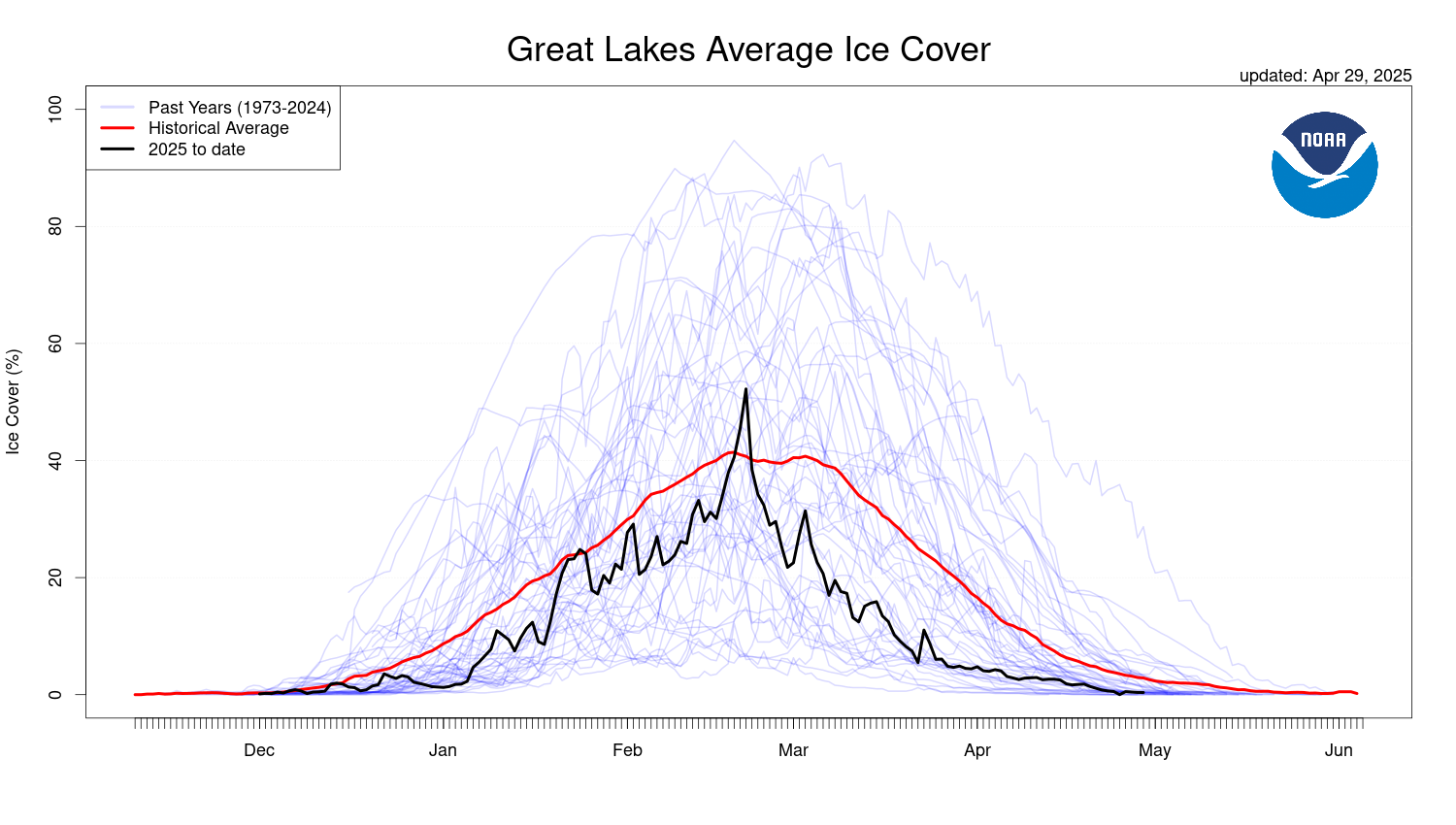
Wow. I have never seen that little of ice on the great lakes.
What is the long rang pattern for a La Nina? Well this from a Chicago TV station claims that it can (and it has) been warmer than average during a La Nina winter as well as a El Nino winter.
“In terms of impacts on Illinois, researchers say that summers tend to be warmer and drier than normal during a La Niña pattern, while fall tends to see cooler and wetter conditions.
Winters tend to be warmer during La Niña events, but Illinois is more prone to cold snaps and heavy snow events, according to researchers.” Here is the story.
https://www.nbcchicago.com/weather/as-a-la-nina-watch-issued-heres-how-the-pattern-could-impact-illinois-weather/3350978/#:~:text=In%20terms%20of%20impacts%20on,see%20cooler%20and%20wetter%20conditions.
So this summer could be warmer than normal or cooler than normal. And, it could be wetter than normal or drier than normal. Got it. 🙂
The official H/L yesterday at Grand Rapids was 42/21 there was no rain/snowfall. The sun was out 67% of the possible time. The highest wind was 19 MPH out of the SW. For today the average H/L is 33/19 the record high of 58 was set in 1938 that year also had the most rainfall of 0.68”. The most snowfall of 5.0” fell in 1900 the most snow on the ground was 21” in 2014 and 1936 there was 20” on the ground in 1985. Last year the H/L was 42/28.
Slim