The sun is expected to make an appearance today to start a generally quiet week for SW Michigan. The next chance of precipitation does not come until Thursday.
NWS Forecast
Weather History
1967: Temperatures plummet to 24 below zero at Lansing and 16 below at Grand Rapids as arctic high pressure moves across Lower Michigan.
On February 12, 2019, the Tri-Cities and Thumb regions saw 3 to 6 inches of snow while areas south of Metro Detroit saw persistent freezing rain. Tens of thousands of residents lost power during this storm.
On February 12, 2003, the city of Port Huron received 5 inches of snow due to a passing snowstorm.
1784: Ice floes were spotted in the Gulf of Mexico after passing out the Mississippi River in February 1784. Ice blocked the river in New Orleans, Louisiana. The ice in New Orleans is one of two times that this occurred during the Great Arctic Outbreak of 1899. The eruption of Laki in Iceland from June 8, 1783, through February 7, 1784, is the likely cause for the severe winter of 1783 – 1784.

1899: The bitter cold outbreak of February 1899 continued across the southern Plains, Texas, and the Deep South. The mercury dipped to 8 degrees below zero at Fort Worth, Texas, and 22 degrees below zero at Kansas City, Missouri. Nebraska’s temperature at Camp Clarke plunged to 47 degrees below zero to establish a state record. The all-time record low for Oklahoma City was set when the temperature fell to a frigid 17 degrees below zero, breaking the previous record low of 12 below zero, set on the previous day. Washington D.C. hit 15 degrees below zero, while Charleston, SC, received a record four inches of snow. Snow was also reported in Fort Myers, Tampa, and Tallahassee Florida.
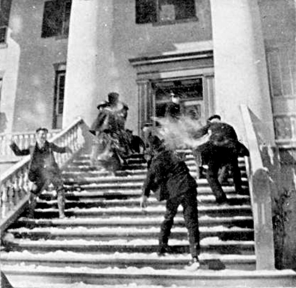
The image above is a snowball fight on the steps of the Florida Capitol building.
1958: Snow blanketed northern Florida, with Tallahassee reporting a record 2.8 inches. A ship in the Gulf of Mexico, 25 miles south of Fort Morgan, Alabama, reported zero visibility in heavy snow on the afternoon of the 12th.

2017: There was an imminent failure of the auxiliary spillway on the Oroville Dam in California.
6:08pm: #OrovilleDam itself is not compromised at current time. Failure would be on auxiliary spillway. See graphic for details. pic.twitter.com/LSxCwsthxC
Forecast Discussion
- Quiet with seasonable temperatures through Wednesday

While we won`t be seeing the 50s and 60s like last week, we are
still looking at mild and quiet weather by mid-February
standards.

Generally speaking, we will remain in between the northern and
southern streams for much of this week, a continuation of the El
Nino type pattern we have seen much of this winter. Ridging is
building in this morning, and it is strong enough to clear out
the lower clouds that plagued the area over the weekend. We will
see at least some sunshine today, with mid and high clouds also
moving through.

We will be close enough to the northern stream so that as a wave
dives ESE toward the area tonight, it will bring a small chance
of some flurries across the northern section of the area.
Moisture is quite limited with this wave and sfc reflection.
What will help out a bit is a northerly flow coming down Grand
Traverse Bay with sufficient over lake instability that a few
snow showers might result up toward Mason and Lake counties.

In the wake of this wave tonight, we will get back under the
influence of upper and sfc ridging for Tuesday and Wednesday.
Temperatures will drop a notch or two for Tuesday in the wake of
the system tonight, but we should still see highs in the mid
30s. Dry weather will persist then for Tuesday and Wednesday.

- Increasing chance of accumulating snow on Thursday

We continue to watch the potential impacts of a stronger wave
that will move through on Thursday, bringing some potential snow
accumulations to portions of the area. Confidence continues to
increase with good agreement amongst the models and ensemble
members. This agreement has got better over the last 24 hours.

What will happen is that there is some minor phasing of northern
and southern stream upper troughs very late Wednesday night into
Thursday. The southern stream trough will come out of the Four
Corners region, while a northern stream trough digs through the
upper midwest and supplies the colder air.

The southern stream does not look to be able to tap much, if any
Gulf moisture ahead of it. This will really limit the amount of
precipitation with this system. The forcing will be sufficient,
along with marginal moisture to bring some precipitation to the
area. A look at 850 mb temperatures indicates that we will see
a limited melting layer reach up almost to the I-96 corridor.
This will help with producing mainly rain across the south where
sfc temps will be warmer.

There will be a transition zone just south of I-96 where sfc
temps below freezing may overlap with some of the melting layer
aloft. This brings in a chance of a little bit of freezing rain.
Any freezing rain would be in short duration and limited
amounts. North of where the melting layer is, roughly I-96 and
to the north, precipitation should be mainly in the form of
snow.

This system is a quick hitter, with limited moisture as
mentioned before. We are looking at the heaviest band seeing 1-3
inches of a wetter snow just north of the sfc low and in
association with the deformation zone of the upper trough. This
could be a problem if we see the snow occur around the Thursday
rush hour. It does look like the precipitation should come
mostly to an end by the end of the day.

- Below average temperatures next weekend with snow chances

We will see colder air then move in behind the Thursday system
as northerly flow advects colder air in from Canada. 850 mb
temps are forecast to drop to below -10C by Friday. These type
of temperatures would be sufficient for some lake effect, and
could produce a few snow showers. Nothing significant or
organized looks likely however. This is because the northern
stream jet core never really stays in place long enough to get
lake effect going. We do not see the cyclonic portion of the jet
really drop into the area. This will keep inversion heights
lower.

We do see another short wave from the northern stream brush by
the area on Saturday once again that could provide some snow
showers. Again, the better placement of the upper wave and jet
core stays just north of the area. This will allow for colder
temperatures with a chance of snow showers.
Let it snow, let it snow, let it SNOW!
https://www.pivotalweather.com/model.php?p=snku_acc-imp&rh=2024021218&fh=120
I heard we will get some snow later in the week. Not much. It won’t stick around long I’m sure. Although we all know winter is not over yet. I have seen a snow storm here the first week of April – just in time for Spring break.
Bring on the SNOW!!!!
The official H/L yesterday at Grand Rapids was 38/28 there was no rain/snowfall. The sun was out only 6% of the possible time. For today the average H/L is 33/19 the record high of 55 was set in 1984 the record low of -23 was set in 1899. The most rainfall of 1.70” fell in 1938 the most snow fall of 5.1” fell in 2019. The most snow on the ground was 21” in 2014. Last year the H/L was 48/28.
Slim
It looks like the official overnight low was 21 that is the coldest it has been this February so far. The low here in MBY was 20 and the current reading here in 24 with broken clouds.
Slim