Yesterday we had a high of 78° and the low was 55° with 100% sun – a perfect day. We have another in store for today with temps warmer than yesterday into the 80s. At this time the only chance of rain appears to be late tomorrow night into Tuesday morning. Below is the SPC forecast for tomorrow.
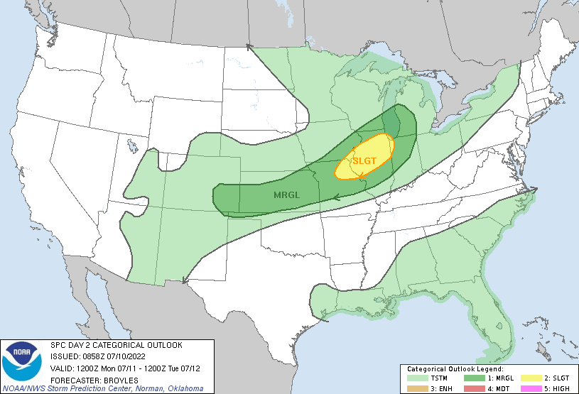
 A shortwave trough will move east-southeastward across the
   north-central states on Monday, as a cold front advances
   southeastward into the mid Mississippi Valley. A corridor of
   maximized low-level moisture will exist ahead of the front, with
   surface dewpoints in the upper 60s to lower 70s F. Moderate
   instability is expected to develop along this corridor during the
   afternoon, with convection initiating near the front during the
   afternoon. A couple of clusters of storms are forecast to organize
   in northeast Missouri and northwest Illinois, moving eastward across
   parts of central and northern Illinois during the late afternoon and
   early evening. NAM forecast soundings from northeast of St Louis to
   near Chicago at 00Z/Tuesday have MLCAPE in the 2000 to 3000 J/kg
   range, with 0-6 km shear of 40 to 50 knots. 0-3 km lapse rates of
   7.5 to 8.0 C/km, along with veered low-level winds to the southwest,
   should be favorable for line segments with wind-damage potential.
The rest of the week will be dry with near-normal temps. As we approach next weekend we will be back to the mid to upper 80s. Above normal temps are predicted to be around through most of the rest of the month.
Forecast Discussion
--Warmer today, but not humid--

High pressure is overhead early this morning, but will drift east
later today. We`re still seeing the drier air from Ontario flow into
the cwa, but that will change later today as the high moves east and
a south to southwest flow develops. Highs today will climb into the
lower to mid 80s, but dewpoints will remain in the lower 50s.

--Showers/storms possible Monday, but moisture is an issue--

A northern stream short wave will push a trough across Lake Superior
and northern Lower tonight. The llj increases to around 40 knots
over northern Lower and this is also where moisture transport vectors
are the largest. That said, the moisture isn`t coming north directly
from the Gulf. Instead, it`s taking a circuitous route from southern
Texas to New Mexico and northeast across the Plains. This may limit
the amount of moisture available for showers/storms. The NamNest is
most bullish on convective activity late tonight over northern Lower
with showers diminishing toward morning as the move south across the
cwa. The GFS doesn`t have much of anything over the cwa and given
how dry forecast soundings are even on the Nam, we`ll have very low
pops in the grids.

If we`re going to see precipitation, Monday night is the best bet,
but even that isn`t all that impressive. Moisture profiles are a
little better, but not much. NamNest shows a line of convection
Monday evening, but the GFS essentially bifurcates the region; some
precipitation falls over the northern cwa and some over the far
southern cwa. The ECMWF shows the most precipitation with a skew
toward the northern cwa/northern Lower and the rest over the
southern cwa.

MUCAPE is maximized during the evening, so if we`re going to see
showers/storms 02z-05z looks like the most likely time. Given
limited moisture, qpf won`t be much more than a tenth or so.

--Dry the rest of the week--Whatever rain we receive Monday night
will likely be it for the rest of the week, which isn`t good
considering the abnormally dry/moderate drought conditions over the
central cwa. There could be a brief shower over the northeast cwa
Tuesday afternoon where the upper trough and cooler temperatures
aloft create some instability but we`re not counting on much if
anything. High pressure rolls in again for the rest of the week.

We will keep a low chance pop in for Saturday when the models show
another short wave moving over the state.

Temperatures will slowly climb to the upper 80s by the end of the
week.
Holy cow, can we have any better weather than this weekend? Simply amazing. My boy and are hitting the links again.
Not only has it been rather dry there continues to be a thunderstorm drought. At Grand Rapids there were only 4 thunderstorms in June (remember the term thunderstorm for this purpose can mean only one detected lightning flash in the area) and there has only been one reported “thunderstorm” so far in July at Grand Rapids. That one did indeed have some moderate lightning with it.
Slim
Yesterday was another great summer day with an official H/L of 80/55. There was once again no rain fall and 99% of possible sunshine. While the sunshine has been great it continues to be rather dry. For today the average H/L has reached the highest for the 30 year average with an average H/L of 83/63 and it will stay at that 83/63 until July 31st for the new 15 year average the average is now at 84/64 and that will stay the same until July 27th so this is on average the warmest days of the year at Grand… Read more »