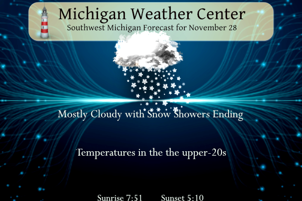
We have 8 inches of snow on the ground this morning. Southern Allegan County seems to have taken the brunt of the lake effect snow bands overnight. Lake effect snow showers will continue this morning off of Lake Michigan. Local accumulations of 1-3 inches are possible this morning, near/west of Highway 131. Expect some slippery spots with temperatures in the teens and 20s this morning. Snow showers will taper off this afternoon. Highs today will top out in the upper 20s to around 30. Brisk northwest-to-west winds will make it feel colder. The winter weather advisory for Mason-Lake-Oceana-Allegan-Barry-Van Buren-Kalamazoo-Calhoun Counties expires at 11 am.
Forecast
Weather History for Southwest Michigan
1955: Bitterly cold arctic air is firmly entrenched across Lower Michigan. The high temperature at Lansing is only 15 degrees, after a morning low of 6. Meanwhile, a foot of lake-effect snow piles up at Muskegon.
Weather History for Southeast Michigan
On November 28, 1991, a winter storm moving through the Great Lakes brought snow, sleet, and freezing rain across the Flint area, leaving 4.4″ of snow by the 28th.
U.S.A and Global Events for November 28th:
November 28, 1921:
New England was in the midst of a four-day ice storm, their worst of record. Ice was more than three inches thick in many places following the storm, and property damage was in the millions of dollars. Northern New England received heavy snow with more than two feet reported in some areas. Overnight freezing rains continued through the day at Worcester, MA while the wind increased to a gale. Streets became impassable even on foot, and whole towns were plunged into darkness without communication. The storm caused 20 million dollars in damage to power lines, telephone lines, and trees.
Forecast Discussion

Current headlines look to be in good shape this morning as lake
effect snow showers, locally heavy at times, continue across parts
of Western Michigan. Ample overlake instability is fueling lake
effect snow showers affecting our traditional northwest flow lake
effect belts. The heaviest of these are affecting
Allegan/Kalamazoo/Van Buren counties at this time. The showers
will continue into the morning hours resulting in areas of slick
travel Tuesday morning across the advisory area. Wind gusts around
20 mph could also cause localized blowing snow.

The trough that has been over the area in recent days exits Tuesday
morning with moisture depth and inversion heights falling under 5000
ft during the day Tuesday. This will cause snow showers to diminish
Tuesday afternoon and evening, drifting northeast while they
dissipate as flow becomes southwesterly in weak ridging.

The next round of snowfall is expected Tuesday night into the start
of Wednesday. Isentropic upglide/warm air advection will take
advantage of increased moisture depth to produce light snow showers
across the northern half of the CWA. Accumulations will be minor,
only an inch or two at most. Snow showers end Wednesday morning as
weak mid-level height rises and subsidence return and moisture depth
decreases once again.

Quieter weather is expected during the long term period of Wednesday
night through next Monday. We will have a few chances for
precipitation, but as WPC guidances shows (7 day QPF of less than a
half inch), much of it will be light. As far as temperatures go, we
will be near normals for this time of year which are highs around 40
and lows around 30.

As for the details regarding sensible weather goes the upper trough
currently in places lifts out to the north during the short term
leaving a zonal upper flow for the most part in the long term with
higher heights leading to a moderation in temperatures. The first
system to watch will be a low that will be centered over MO/AR by
Friday morning. The low shears out towards the eastern Great Lakes
on Friday spreading light precipitation into Southern Lower Michigan
on Friday. Temperatures should be just warm enough for the
precipitation to fall as rain, but there could be a bit of a rain
snow mix on the northern fringes near I-96. The precipitation should
end Friday night as the system moves away/weakens.

The forecast is less clear as we head through the weekend and into
next week. Operational runs of the ECMWF and GFS have differing
solutions with regard to the strength and location of shortwaves
embedded in southwest flow aloft on Saturday. In general they agree
on upper troughing developing in the Plains over the weekend and
moving into our area by Monday. At this point it looks like fairly
good chances for a cold rain during the Sunday/Monday time frame.

Bottom line...no major systems to deal with at this point with near
normal temperatures.
Lake effect totals of 16” south of Buffalo. Upstate New York the top total I could find so far is 23”
We have 6.5-7 inches.. north of MV by about 10 mins.
Below average snow about to melt. CPC looks warm!
What a fantastic winter day! Fresh snow, cold temps and sun! Get outside and enjoy! I will be heading out for an incredible winter hike this morning! I love these temps! Wow, just wow, WOW!!!!!!!
Only about an inch here at my house. It’s actually sunny out right now. It’s currently 17 here.
The official H/L yesterday at Grand Rapids was 33/21 there was 0.04” of water in 0.9” of snow fall. At 7AM there was a trace of snow on the ground. There was 0% of possible sunshine. For today the average H/L is 42/29 the record high of 67 was set in 1905 and the record low of 5 was set in 1969. The wettest November 28th was in 1968 with 1.58” of rain fall. The most snow fall of 7.9” fell in 1965 and the most on the ground was 6” in 1940. Last year the H/L was 43/32. At… Read more »
Impressive snowfall, MV! My wife drove home from Chicago last night. It took her 90 minutes longer than usual.
Glad she made it home alright. Here in MBY there is only around a half inch of snow on the ground.
Slim
My dad used to race over there…we would always joke how snow storms would always come in on the days he raced