Yesterday was great with all sun and the temperatures in the low 60s. This week it will be time to put down the lawn fertilizer with weed deterrents. I have started the tomatoes inside anticipating fresh tasty fruit this summer. Yes, the tomato is a fruit, I don’t care what the government says. Tomatoes are botanically defined as fruits because they form from a flower and contain seeds. Still, they’re most often utilized like a vegetable in cooking. In fact, the US Supreme Court ruled in 1893 that the tomato should be classified as a vegetable based on its culinary applications. Must have been a slow day. 🙂
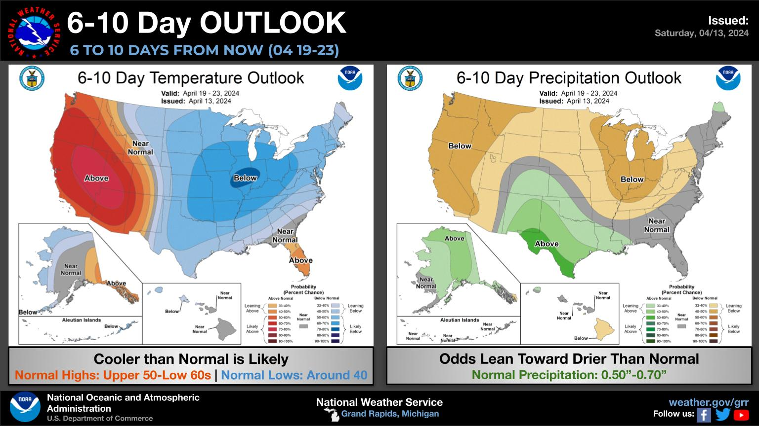
CPC Outlook
NWS Forecast
Weather History
1953: It is a cold morning across Lower Michigan. Record low temperatures include the 20 degrees at Muskegon and the 21 degrees at Grand Rapids.
On April 14, 2018, a mid-season Spring storm spanning April 13th-15th reached its peak. After widespread rain the night of April 13th ended as freezing rain and accumulating sleet the morning of the 14th, precipitation wound down and strong marine winds continued for the remainder of the day. Wind gusts over 50 mph were common in Saginaw Bay and the shoreline of Bay County where storm surge inundated coastal communities. Severe coastal flooding was also observed in Monroe County along the Lake Erie shoreline. Freezing rain and sleet redeveloped early on the morning of the 15th before ending as rain that afternoon. All told, Southeast Michigan had observed 2-3″ of heavy rain, 2-3″ of sleet, and 1/4″ to 1/2″ of ice from freezing rain. DTE and Consumers Energy reported power outages for nearly 500,000 customers due to the event.
In addition, the 0.6″ snow measurement, which was mostly sleet, made on the 15th tied Flint for its snowiest winter on record at 83.9″. This tied the record set just 4 winters prior in 2013-2014.
Also on April 14, 1967, Saginaw County reported an F1 tornado around 7:20 pm. Property damages were recorded at $250,000.
1886: The deadliest tornado in Minnesota history razed parts of St. Cloud and Sauk Rapids, leaving 72 dead and 213 injured. 11 members of a wedding party were killed including the bride and groom. The bottom of the Mississippi River was seen during the tornado’s crossing. Click HERE for more information from the StarTribune.
1912: On her maiden voyage, the RMS Titanic rammed into an iceberg just before midnight. The “unsinkable ship” sank two hours and forty minutes later into the icy water of the Atlantic Ocean near Newfoundland, Canada. Tragically, 1,517 passengers including the crew were lost. A nearby ship, the Carpathia, rushed to the Titanic and was able to save 706 people.
1922: The Mississippi River reached a record height of 21.3 feet at New Orleans, Louisiana, and the river was still rising, with the crest still a week away. Understandably, the City of New Orleans was nervous as reports of levees failing upriver reached the city. A crevasse below New Orleans would relieve the pressure on the town’s strained levees on the 27th, spared the city from disaster.
1935: Black Sunday refers to a particularly severe dust storm that occurred on April 14, 1935, as part of the Dust Bowl. During the afternoon, the residents of the Plains States were forced to take cover as a dust storm, or “black blizzard,” blew through the region. The storm hit the Oklahoma Panhandle and Northwestern Oklahoma first and moved south for the remainder of the day. It hit Beaver around 4:00 p.m., Boise City around 5:15 p.m., and Amarillo, Texas, at 7:20 p.m. The conditions were the most severe in the Oklahoma and Texas panhandles, but the storm’s effects were felt in other surrounding areas.
1999: In Sydney, Australia, a hailstorm causes $1.6 billion in damage, making it the costliest hailstorm to strike a populated city in the country. The hail damaged some 22,000 homes and more than 60,000 vehicles. Also, aircraft damage at Sydney Airport was extensive.
Forecast Discussion
- Mostly sunny and mild today/Monday

Interesting little system moving across northern
Wisconsin/northern Lower early this morning. A strong surge of
warm air aloft coupled with robust mid level lapse rates is
helping to produce showers/storms over northern Wisconsin/northern
Lower. Present indications are such that almost all of the rain
will remain north of the cwa, but it`s possible that the northern
row of counties could get clipped with a few showers.

We`ll be solidly in the warm sector today and temperatures will
respond by climbing into the lower to mid 70s before the trailing cold
front moves through later this afternoon.

High pressure will build into the region Monday rendering clear
skies and slightly cooler temperatures compared today. However,
highs in the upper 60s will still be 10 degrees or so above
normal.

- Risk for Thunderstorms Remains Late Tuesday into Wednesday

An upper jet at 250 mb is currently digging into CA/NV and will move
east over the coming days, strengthening as it does so. By Late
Tuesday into Wednesday, Lower Michigan is likely to be positioned in
the left exit region of this upper jet, with upper divergence
present overhead. At 500 mb, models continue to forecast upper low
development over the Rockies and central Plains by late Monday into
Tuesday with a low level jet developing as well as surface
cyclogenesis. Surface low occlusion is forecast to quickly take
place shortly thereafter across the Midwest by Tuesday night. This
low is expected to track over Lower Michigan Wednesday. The
GEFS/CMC/ECE probabilities for measurable rainfall during this
period from Tuesday night into Wednesday is 90%-100% region-wide.

During the day Tuesday, not much may be happening as we await warm
air advection aloft and a rise in low level moisture. This may be
delayed until late in the day. Areas south of I-96 are most at risk
for some showers primarily after 18z Tuesday. Model trends seem to
be delaying this threat a touch so in a reality much of the region
may stay dry for a good portion of the day before a surface warm
front is slated to arrive Tuesday night. It is during the 00z-06z
Wednesday time frame that the environment may start to be conducive
to some showers and elevated thunderstorms.

Showers and some thunderstorms are likely to be ongoing at the start
of Wednesday morning. The ECMWF and GEM have slightly slowed the
arrival of a surface cold front across the region Wednesday
afternoon, which may give areas especially near and south of I-96 a
chance to build some surface based instability depending on what
happens with the morning activity. Numerous ensemble members as well
as the deterministic runs of the GFS and GEM show the potential for
1000+ J/kg of SBCAPE to develop. Tough to say at this point whether
this will be reality, but the risk is certainly there. Fairly strong
winds aloft at 850 mb (40 kts) and 500 mb (40-50 kts) could be
tapped with any convection that develops, though deep layer shear
does not look overly impressive at 30-35 kts. Still, thunderstorms
with strong wind gusts look to be the main hazard on Wednesday. With
a warm front lifting at least as far north as I-96, we`ll also have
to watch for potential for any surface based storms that can tap
into extra low level shear and storm relative helicity along that
boundary.

- Turning Cooler Late Next Week

GEFS mean 500 mb heights indicate troughing will be dominant across
the Great Lakes late in the week and weekend. Cold air advection at
850 mb looks to be slow but steady from Thursday into the weekend.
Declining temperatures at the surface can be expected during this
time as highs retreat into the 50s Thursday and Friday, then
possibly 40s for Saturday. Periodic rain showers are possible during
this time. Depending on cloud cover over the weekend, frost/freeze
conditions may develop.
70 before noon. Shorts weather. Gorgeous day to be outside.
Absolutely perfect day out! Who wouldn’t want weather like this in April??
A bit to warm for this time of year, but it is only going to last a couple days!
Yep, the cool down is only going to last a couple days then right back to beautiful spring golf weather again!
https://weather.com/weather/tenday/l/52aab230ef88e4f2bb12857231a5dd58392e78a71b90e01d57a11d827658eb55
Not that cool, actually. The average high is 57. For comparison purposes, it’s 77 here now.
Agreed, mid 50’s is pretty darn normal for this time of year!
Enjoy the next couple days, because after that the bottom is going to fall out! Get ready!
Boy gardens are on the minds…
We only do a few things… our soil (sand…even when I put soil in) and the wild critters will have their way with free food.
My raspberries do have leaves on some of the plants I noticed last week.
The official H/L yesterday was 58/42 there was no rainfall, the sun was out 100% of the possible time. The average wind speed was 11.3 MPH and the peak gust was 29 MPH out of the W. For today the average H/L is 57/37 the record high of 83 was set just last year. The record low of 21 was set in 1943 and 1953. The most rainfall of 1.07” fell in 1987 the most snowfall of 4.1” was in 2019 the most on the ground was a trace in several years. Last year had that record high of 83… Read more »