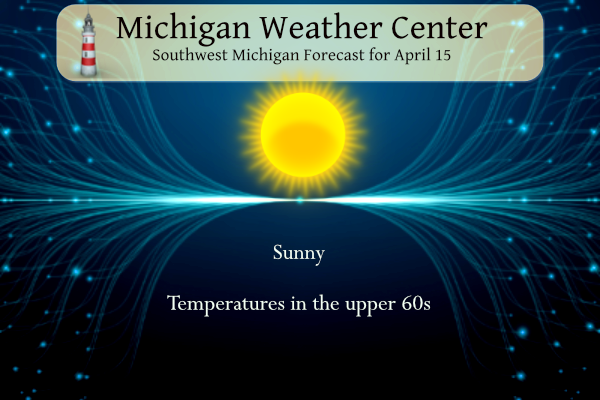
Yesterday we reached 76° with lots of sun and low dewpoints. No mosquitoes yet but beware there are ticks so check yourself and your pets when you come in from outside. Today will be another sunny day with temperatures once again near 70°, just a bit cooler than yesterday. Our mild pattern will continue through tomorrow but a wave of low pressure moves in for Wednesday. This system will bring showers and a risk for thunderstorms with it. Cooler weather will follow at the end of the week.
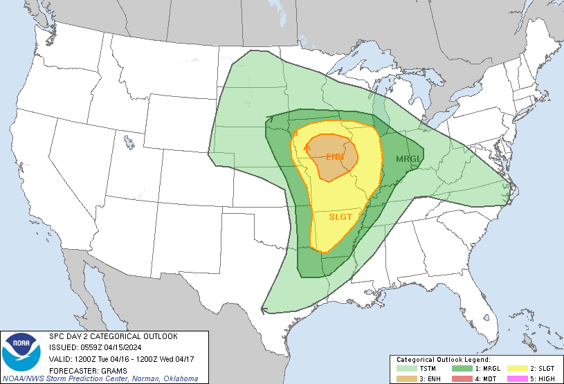
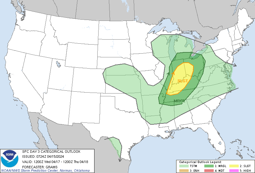
SPC Outlook for Tuesday and Wednesday
NWS Forecast
Weather History
1943: Temperatures plunge into the teens as snowflakes swirl in the arctic winds. Record lows include 16 degrees at Muskegon and 18 degrees at Grand Rapids.
2002: Four days of record warm weather peaks across Lower Michigan with Grand Rapids hitting 86 degrees and Lansing 84.
2018: A late-season winter storm brought up to 4 inches of snow, 2 inches of sleet, and almost half an inch of icing along with strong winds across Lower Michigan from the 14th to the 17th. Almost half a million people lost power.
On April 15, 2023, a period of anomalously warm early April conditions came to an end. High temperatures in the 80s set new records at Detroit, Flint, and Saginaw, on April 12, 13, 14, and 15. This was the second warmest start to April on record at Flint and Saginaw, behind 2010.
On April 15, 2014, light snowfall, the last of the season, blanketed Southeast Michigan. Detroit and Flint received 3.2″ and 1.3″, setting a new record for the snowiest winter at each location. Detroit recorded 94.9″ for the 2013-2014 winter season while Flint finished with 83.9″. Saginaw would eventually finish the season at 60.3″, its 15th snowiest winter.
Also on April 15, 1904, a two-day snowstorm ended in Saginaw. The storm left the city with 12.5 inches of snow.
Also on April 15, 1976, the county of Midland was hit by an F1 tornado at 3:30 PM causing $25,000 in property damage.
1927: The Great Mississippi River Flood of 1927 continued to rage. Tremendous rains all over the Mississippi River Valley during the preceding autumn and winter sent floodwaters raging southward over a wide area. On this date, the government levee at Dorena, MO collapsed. The surge of floodwater continued pushing downriver toward the Mississippi Delta, bursting more dams as it went. Also on this day, New Orleans saw 15 inches of rain in 18 hours. More than 4 feet of water covered parts of the city.
1998: An F3 tornado hits downtown Nashville causing extensive damage but no loss of life. An additional 62 tornadoes touched down in Arkansas, Kentucky, and Tennessee. These tornadoes caused 12 fatalities and approximately 120 injuries.
2000: What a difference a day made (with the help of a strong cold front). Yesterday’s 86 degrees in Goodland, Kansas, tied the record high for the date. Today’s high of 29 degrees was also a date record high, but a record low high. It was a new record by 3 degrees.
Forecast Discussion
- Sunny and mild today, Increasing clouds Tuesday

Latest satellite imagery shows mostly clear skies across the upper
Great Lakes thanks to high pressure building into the region.
North winds aloft will result in cooler temperatures today
compared to yesterday; mid 60s to around 70.

Clear skies tonight will send temperatures down to near freezing
near US-10 and to the mid 40s near I-94.

A developing Plains low will move in this direction Tuesday. We`ll
see increasing clouds during the afternoon. Strong warm front
activity will see showers and storms develop over the MS Valley
and move east toward Lower MI. Most likely, precipitation will
hold here off until Tuesday evening.

We`ll see east winds strengthen Tuesday, so highs in the lower to
mid 60s will feel a bit cooler than that.

- Risk for Thunderstorms Tuesday Night into Wednesday

The arrival of a low level jet, weak elevated instability and a low
level Theta-E ridge will support an increased risk for a few
thunderstorms Tuesday night.  An approaching upper level wave from
the southwest will also generated diffluence aloft so deeper lift
lift is looking likely.  As a result, we will maintain the risk for
showers and thunderstorms then.

On Wednesday, the mid to upper wave tracks through.  Models are
generating some surface based instability with the highest values in
southern parts of the CWA. The ECMWF and GFS generally keep the
instability limited with values under 750 J/kg but the CMC is much
higher with values topping 1000 J/kg in the afternoon. Afternoon
deep layer shear values are generally shown to be in the 30 to 40
knot range so some organized convection is possible.


- Steady cool down for the end of the week

The wave that tracks through the region on Wednesday lifts up into
Southern Hudson Bay on Friday.  Cold air advection on the backside
of this system strengthens over the Great Lakes Region resulting in
steadily falling 850 mb temperatures. The 850 mb thermal trough
arrives on Saturday, with values around -8 deg C, so a cooler than
normal temperature pattern is expected.  Ridging moves in by Sunday
so that will help to scatter the clouds out.  With some potential
for clearing and a ridge moving in, we will potentially see
overnight lows dipping down to around the freezing mark both
Saturday night and Sunday night.
No 70’s in sight! Facts are facts people! Incredible!
70:degrees? May not see that again for weeks! WOW!
Rocky (Rockford)
There is a very small chance that GR hits 70 degrees tomorrow, but after that no 70’s in sight for weeks on end, despite the constant hype! WOW!
April 7, 2024 8:55 am
Rocky (Rockford)
Don’t look now, but below normal temps are right around the corner (by next weekend)! Enjoy the temps around 70 degrees on Sunday and Monday, because that will be the end of it for awhile! Get ready to Rock!
April 12, 2024 8:10 am
Breaking News>>>>> today actually was a good weather day for golf! Temps around 70 degrees, sunny and a light wind! Not the temps in the 50’s with 20 to 30 mph winds! Incredible! Don’t get used to sun and temps in the 70’s because those days are over for a while! Just the facts people! Get used to it!
Went to Oval Beach yesterday. Lots of people enjoying summer-like temps in mid April. Saw two swimmers. Car said 78 degrees on the way home.
That sounds awesome, just a perfect day yesterday! I just can’t understand how anyone would be rooting for highs in the 40’s and lows around freezing this time of year???
Get ready – lows around freezing this weekend! Wow!
The official H/L yesterday was a very warm 76/47 there was no rainfall and there was 97% of possible sunshine. The average wind speed was 12.1MPH and the highest gust was 32 MPH out of the SW. For today the average H/L is 58/37 the record high of 84 was set in 2002 and 2003 the record low of 18 was set in 1943 the most rainfall of 1.40” was in 1991 the most snowfall of 4.0” was in 1919 that year also had the most on the ground with 3” Last year the H/L was a warm 81/59.
Slim
It was a spectacular day yesterday. We spent quite a bit of time outdoors. I should have used some sunscreen, though. My face and arms are a little pink today.
It certainly was… I thought my face looked like it got a little color too. Lol. We were out pretty much all day.