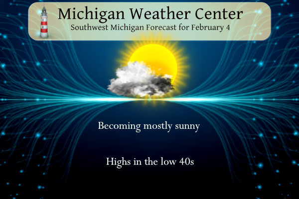
We have very mundane weather to start the month of February. Our next system won’t come until late in the week. Areas that see fog this morning and overnight tonight could see some slick spots on roads and sidewalks along with the reduced visibilities. Partly cloudy skies are expected over the next few days with highs in the upper 30s to low 40s. Thursday and Friday may see temperatures in the low to mid-50s with rain moving in.
Forecast
Weather History
On February 4th 2018, a period of accumulating snow spanning two days came to an end. Most of Southeast Michigan saw 4-6″ with a peak observation of 6.1″ near the town of Peck.
Also on February 4, 2006, the city of Fairgrove in Tuscola County received 10.0 inches of snow. The snowstorm lasted from the 4th to the 5th.
Also on February 4, 2007, arctic air plunged over the Great Lakes Region with strong winds. The high temperature at Detroit was only 8, Flint was 4 and Saginaw was 5 above zero. The arctic air mass remained in place through the 6th.
1838: An ice jam on the Grand River causes flooding of much of Grand Rapids during early February. Several people had to be rescued from flooded neighborhoods and at the fur trading post.
1996: One of the coldest arctic outbreaks of the 20th century sends the thermometer down to 17 below zero at Grand Rapids and 19 below at Muskegon, both records for the date.
U.S.A and Global Events for February 4th:
1842: A dreadful tornado passed over Mayfield, Kirkland, and other Cuyahoga and Lake Counties in Ohio. According to the Cleveland Herald, no less than 30 houses, barns, and buildings were entirely demolished or very much shattered. A “report from Kirtland says that one man and one child are dead.”

The Evening Post-New York, New York 18 Feb 1842, Fri • Page 2
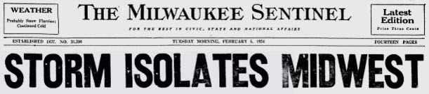
1924: In Milwaukee, Wisconsin, 20.3 inches of snow fell in 24 hours. This ranks as the most snowfall in 24 hours since 1884. This storm caused over $1 million in damage. Streetcar and train service crippled. Snowdrifts of 8 to 10 feet high were common, along with much ice on trees and wires. Schools were closed, and several plate glass windows were broken.
1995: A massive nor’easter pounded areas from the southern Mid-Atlantic to northern New England. It would be the only significant storm in the 94-95 winter season. Over 20 inches of snow buried parts of upstate New York. Wind chills dropped as cold as 40 degrees below zero. Behind the storm, arctic air crossing the relatively warm waters of the Great Lakes produced intense lake effect squalls for nearly two weeks from the 4th through the 14th. Snowfall totals for the storm ranged from near two to seven feet. During the storm east of Lake Ontario, snow was falling at the incredible rate of five inches an hour! The heavy snow combined with strong winds produced whiteouts and hazardous driving. Actual storm totals downwind of Lake Erie included: Erie County: West Seneca 39 inches, Orchard Park 36 inches, Cheektowaga 36 inches, Colden 32 inches, and Buffalo Airport 31 inches; Genesee County: Corfu 38 inches; Chautauqua County: Sinclairville 27 inches and Jamestown 15 inches. Downwind of Lake Ontario, storm totals included: Oswego County: Palermo 85 inches, Fulton 60 inches, and Oswego 46 inches; Lewis County: Montague 66 inches, Highmarket 48 inches, and Lowville 36 inches; Cayuga County: Fairhaven 36 inches, Wayne County: Wolcott 22 inches; and Jefferson County: Adams 47 inches.

Above is the surface map of the nor’easter on February 5th, 1995.

The snowfall graphic above is courtesy of the Midwest Regional Climate Center.
2011: A winter storm settled four to six inches of snow over northern Texas, including Dallas, just days before the Super Bowl between the Pittsburg Steelers and the Green Bay Packers. Click HERE for more information from the CBS News in Dallas/Fort Worth. Click HERE for more information from NASA.
Forecast Discussion
- Freezing Fog possible Sunday and Monday mornings

High pressure continues to dominate the pattern through early
week. Unlike last night the winds remain mostly calm so there
isn`t the consistent low clouds spreading from the east. With
the ridge of high pressure situated over Michigan moisture
continues to stream around it. The dry air alfot will stifle
any clouds. The big question is moisture infiltrating from the
south and encroaching form the north. This will allow for low
stratus along the I 94 corridor and in and around Ludington
respectively.

 As the lows drop overnight and low level moisture pools, expect areas
of patchy to dense fog to form towards morning. With
temperatures already in the mid to low 20s and dewpoints
hovering between 20 to 25, any fog that forms will be freezing.
Though timing remains in question any freezing fog that forms
could allow for some icy spots on roadways.
 Temperatures should warm to above freezing mid to late morning
which should allow for any fog to lift and dissipate. Any low
clouds should dissipate as well allowing for mostly clear skies
this afternoon into evening.

  Another round of freezing fog and low clouds will be possible
Sunday night into Monday. High pressure pressure will retrograde
westward. Expect low clouds to move in from the east Sunday
night into Monday morning. Along with that will be the potential
for patchy freezing fog which could be problematic for the
Monday morning commute.


- Warm Temperatures and Periods of Rain Thursday Into the Weekend

Temperatures warm Tuesday through the end of the work week as we
move more into southwest flow starting Tuesday night and the ridge
gradually shifts east. Highs in the 40s with lows in the 20s and 30s
are expected initially, but with the warm air advection with the
southwest winds ramping up into Thursday and Friday temperatures
could get into the 50s with lows mainly in the 40s. This is also
seen in the ensembles with more members than not showing highs in
the 50s and correlates well with 925 mb temperatures with values
around 6 Celsius.

The support from warm air advection and strong southwest flow with
the low level jet will also bring the potential (50 to 70 percent)
for rain. Ensemble members highlight this well with members bringing
in measurable precipitation mainly Thursday night into Friday. At
this time Friday doesn`t look to be a complete washout as the
shortwave embedded within the broad through moves through quickly.
Within this pattern there could be some additional shortwave troughs
with associated vorticity maximums. Timing of these is not exact
this far out, therefore no changes to the probability of
precipitation from the NBM around 20 to 30 percent through the
weekend.
It is absolutely wild in California.
…WINTER STORM WARNING REMAINS IN EFFECT UNTIL 4 AM PST TUESDAY
ABOVE 5000 FEET…
* WHAT…Heavy snow expected above 5000 feet. Total snow accumulations of 4 to 6 feet. Total snow accumulations as high as 8 feet are possible at elevations above 8,000 feet. Winds gusting as high as 75 mph.
WOW, just wow, WOW!!!!
The sun is good but it would be a lot better, if it was with fresh snow on the ground and temps around 20 degrees! Bring on the real winter weather baby! Rock n roll will never die!
Another gorgeous sun warmed afternoon! Who would have thought??
A rare Level 4 of 4 risk of excessive rainfall was expanded Sunday to include Los Angeles, in addition to Santa Barbara and Oxnard in Southern California, with the weather prediction center warning of “life threatening flash and urban flash flooding.” Rainfall rates up to an inch per hour will bring 3 to 6 inches of rain across the area. A more widespread Level 3 risk exists for much of coastal California, including San Francisco.
https://www.cnn.com/2024/02/04/us/california-atmospheric-river-flooding/index.html
I remember this song from my teenage years
https://youtu.be/meDpNwem0Vo
That tornado west of Miami is literally coming directly at me. Still 15 miles away though but maybe I’ll be able to see it in the distance
I will take this sunny mundane weather over the clouds!!!
“It’s well likely that some winters in the near future will be even warmer in relativity than the one we’re experiencing right now.”
https://www.mlive.com/weather/2024/02/michigans-upper-peninsula-smashes-records-in-warmest-start-to-winter-on-record.html
Another very cold morning! Who would have thought?
That’s a cool write up on the tornado outside of Cleveland. A tornado in the middle of winter is just crazy.
The overnight low here in MBY so far has been 22. And that is the current reading with a lot of frost.
Slim
The official H/L yesterday at Grand Rapids was 35/25 there was no rain/snow the sun was out 48% of the possible time. For today the average H/L is 31/18 the record high of 53 was set in 1962 and the record low of -17 was set in 1996. The biggest snowfall of 10.0” fell in 1900 the most snow on the ground was 20” in 1959. Last year the H/L was 35/9 and there was 5” of snow on the ground.
Slim