The sunshine and warmer temperatures we had yesterday are once again in store today. We reached 50° yesterday. We’ll see continued sunshine during the first half of the week. Rain returns Thursday night with the next storm system. Temperatures during this time will gradually warm with highs likely near 60° Thursday before dropping back into the 40s for the weekend.
Forecast
Weather History
1890: Temperatures more like April than February prevail during one of the mildest winters on record in Lower Michigan. Lansing sets a record high of 61 degrees for the second day in a row.
1918: Frigid weather holds on across Lower Michigan with the temperature falling to record lows of 16 below zero at Muskegon and 21 below at Lansing.
On February 5, 2014, a winter storm 6 to 8 inches of snow to Southeast Michigan. The highest accumulations were measured in Wayne, Washtenaw, and Monroe counties including 8 inches in Detroit. Flint recorded 5.8 inches while Saginaw recorded only 4 inches.
Also on February 5, 1918, the overnight temperature dropped to -23 degrees in Saginaw. This is the record low for this city!
USA and Global Events for February 5th:
1745: Today is National Weatherman/Meteorologist Day, commemorating the birth of John Jeffries in 1745. Jeffries, one of America’s first weather observers, began taking daily weather observations in Boston, MA, in 1774, and he made the first balloon observation in 1784. You can read a narrative from the Library of Congress of the two aerial voyages of Doctor Jeffries with Mons. Blanchard: with meteorological observations and remarks. The first voyage was on November 13th, 1784, from London into Kent. The second was on January 7th, 1785, from England into France.
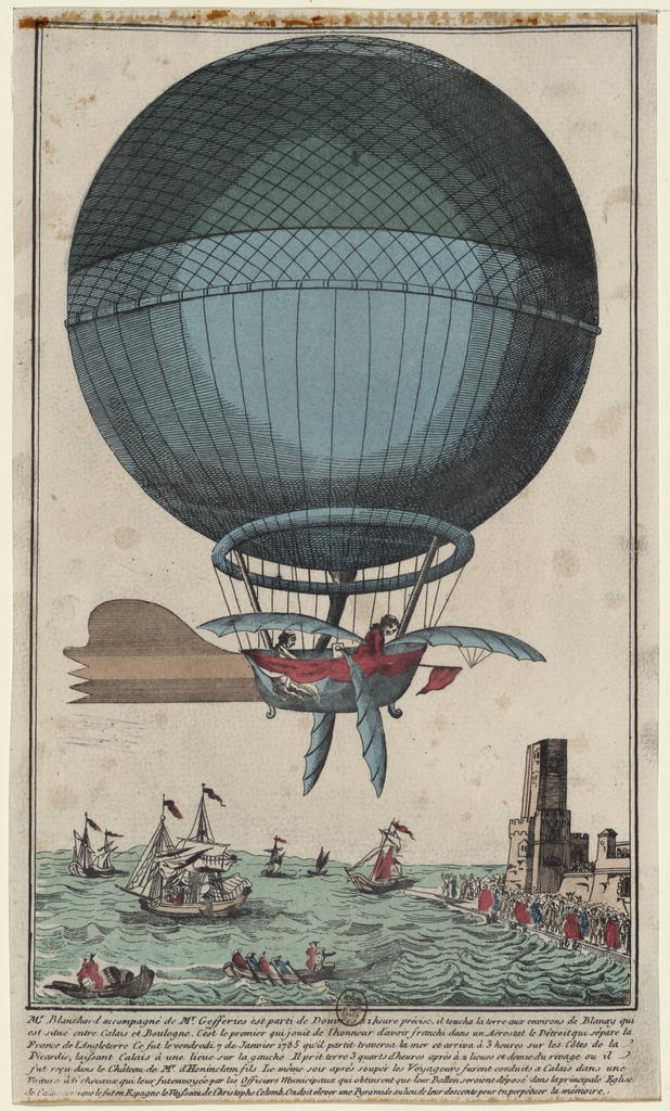
The image above is from the Library of Congress.
1887: San Francisco experienced its most significant snowstorm of record. Nearly four inches was reported in downtown San Francisco, and the western hills of the city received seven inches. Excited crowds went on a snowball throwing rampage.

The image above is from the Chronicle archives. Additional photos can be found here.
1920: An intense nor’easter dumped 17.5 inches of snow over three days in New York City Central Park, New York. Boston, MA, saw 12.2 inches of snow on this day.

The image above of Hudson St., New York, is courtesy of the Library of Congress.

The image above of West St., New York, is courtesy of the Library of Congress.

1976: Record-breaking snowfall of just two inches fell in Sacramento, California. February 5, 1976, is the only time since November 1941 when snow was reported in Sacramento.

The picture above is from The Sacramento Bee Sacramento California 05 Feb 1976, Thu • Page 7

1986: A supercell thunderstorm tracked through the Tomball area northwest of Houston, TX, and produced four tornadoes along with damaging microburst winds and up to tennis ball size hail. An F3 tornado killed two people, injured 80 others, and devastated a mobile home park and the David Wayne Hooks Airport. In addition, 300 aircraft were either damaged or destroyed. Much of the more substantial hail was propelled by 60 to 80-mph winds, resulting in widespread moderate damage. The total damage from this storm was 80 million dollars.

2008: The Super Tuesday 2008 Tornado Outbreak has been one of the deadliest tornado outbreaks in the US, with 59 fatalities reported. So far, it ranks in the top 15 deadly tornado outbreaks (and the highest number of tornado deaths since 1985). According to the SPC Storm Reports, there were over 300 reports of tornadoes, large hail (up to 4.25 inches in diameter in Texas, Arkansas, and Missouri), and damaging wind gusts from Texas to Ohio and West Virginia. The outbreak produced at least 64 tornadoes, some producing EF-3 and EF-4 damage. Click HERE for Satellite information.

Forecast Discussion
- Fog and Low clouds possible Monday and Tuesday morning

 Patchy fog/freezing fog will be possible early this morning
which could allow for some slick spots for the morning commute.

 High pressure will continue to dominate the weather pattern
through mid week. As such one of the main weather concerns will
be nightly to early morning low clouds and fog. As the last few
days have shown, a sunrise surprise of patchy fog should be
expected. Unlike last night the predominately mid level flow is
northerly, moving off of Lake Huron and Lake Michigan. This is
unlike last night where there was a large wind component moving
in from Lake Erie which affected the I 94 corridor.
 The winds this morning will cause the clouds to encroach from
the north and the northeast especially along the US 127
corridor. The northeast winds off of Saginaw Bay are bringing in
clouds which have enhanced the moist low level flow enough to
bring light snow in addition to freezing fog .

Calm winds at the  surface and dewpoints in the low 20s should
allow for an environment for freezing fog. Clear skies aloft
should allow for temperatures to drop low enough just before
sunrise for this to happen. Low clouds and patchy fog should
lift and dissipate late in the morning into early afternoon.
After that, clearing skies and unseasonably warm temperatures
will occur but that will be discussed in the section below. As
high pressure will continue to dominate the weather pattern
through at least tomorrow expect another round of fog/low clouds
to occur tonight into Tuesday morning.

- Record Max Temperatures possible this week

 Well above normal temperatures are likely through Thursday with
highs in the 50s likely and potentially upwards of 60 possible.

As stated above once the clouds clear the big issue will be
unseasonable warm temperatures. The Climate Predictions Center
(CPC) has been indicating this trend for quite some time. The
mid to long range models as well have shown that above normal
temperatures through early February was likely. Yesterday
Muskegon tied its record high temperature for the day with 52
degrees. The other time that happened was 2019. Grand Rapids was
three degrees off its record. The 925 mb temperatures continue
to be warm today into tomorrow though the high pressure does
retreat briefly due to a back door cold front that will be
moving through the east side of the state. NAEFS and EC
ensembles continue to show that this warming will continue
through the week as anomalous temperatures will be +2 standard
deviations through Thursday. There is the potential for upwards
of 60 degrees by Thursday especially along and south of the I 96
corridor. Temperatures will drop down back closer to normal
towards and through the weekend.


- Rain Returns Thursday Night into Friday

Pressure heights decrease with positive vorticity advection and
moisture working their way over the area for Thursday night. It also
looks like the left exit region of the upper level jet will provide
some additional synoptic support Thursday night. Therefore have
bumped up the probability of precipitation Thursday night in the 60
to 80 percent range. Ensembles again are honing in on the later
start time. Gusty southwest winds are also expected due to the low
level jet overhead.

The main area of moisture and lift shifts east Friday, but some
lingering showers are possible (30 to 40 percent) through the
remainder of the day before the front moves through Friday night.

- Colder Temperatures and Chances For Light Snow This Weekend

There is some uncertainty with how the pattern evolves after the
frontal passage. This can also be seen in the ensembles with pockets
of measurable precipitation and dry conditions depending on the
member. However temperatures look to cool down, but remain above
normal for this time of year. Highs over the weekend are expected to
be in the upper 30s to 40s with lows in the 20s to 30s. With these
two pieces of the puzzle put together, stuck with the NBM
probability of precipitation (20 to 30 percent) and depending on the
temperature expect either rain or snow.
3pm with low clouds and ice still on the trees! Blowtorch? What blowtorch? Not here! Incredible!
Today marks our 14th day in a row of significantly warmer than average temps.
Yeah this 28 degrees and freezing fog at my house sure is sweltering for this time of year.
Currently in the mid 40’s again at GR!
The cold weather crazies are getting grumpy because this winter has been completely opposite of their fall wishcasts! Everyone knew going in that we were going to be in a strong El Niño, but the cold weather crazies all said no, we’re looking at 110 inches of snow and highs in the teens and twenties from November through the end of March! Well, as we near the end of winter, El Niño is winning the battle, quite handily as we are FAR BELOW normal snowfalls and FAR Above Temperature wise!
Today is National Weatherman/Meteorologist Day (see above}
Wow 50 for February 4th?? That is quite impressive for sure
Some very interesting weather history on this date. I did not know about the snowstorm in
San Francisco
Slim
It was once again a very frosty night and the overnight low here in MBY was 19. At this time it is clear and 25.
Slim
The official H/L yesterday at Grand Rapids was 50/23 that 50 was the 3rd warmest February 4th at Grand Rapids. There was no rain/snowfall. The sun was out 100% of the possible time. For today the average H/L is 31/18 the record high of 52 was set in 1991 and the record low of -16 was set in 1985. The most snow on the ground was 21” in 2014 there was 20” on the ground in 1959. Last year the H/L was 39/29 and there was 5” of snow on the ground.
Slim
Another very cold morning and the pattern will be changing to a real winter pattern next week! This week is horrible winter weather!
Eeeee Eeeee Blowtorch warning remains in effect!