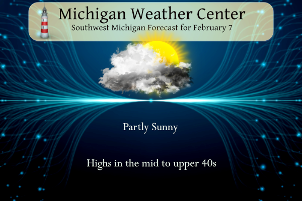
We will see more clouds than in the past few days. We will see sunshine at times with a breeze from the south. Temperatures will gradually warm with highs likely in the 50s for most of the area Thursday. Conditions cool over the weekend into early next week.

Enjoy the warmth expected across southwest Michigan through Friday as a cooldown is on the way. High temperatures fall into the upper 30s by the weekend and into the low to mid 30s after Valentine’s Day.
NWS Forecast
Weather History
1899: The greatest arctic outbreak in United States history begins a period of extreme cold in Michigan. Grand Rapids hits 15 below zero. During the next week, temperatures will fall to all-time record lows across the state and much of the continental U.S.
On February 7, 1895, the daytime temperature rose to only 2 degrees in Detroit, which is the record daily low daytime temperature. This was also the third day in a row (February 5-7) that daily low daytime temperature records were set.
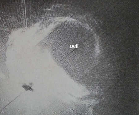
A blizzard raged across the Great Plains. Many pioneers, unprepared for the cold and snow, perished in the tristate region of southwest Minnesota, northwestern Iowa, and southeastern South Dakota. Visibility was down to three feet. Cows suffocated in the deep drifts, and trains were stuck for days. More than 70 people died; some bodies were not found until spring.
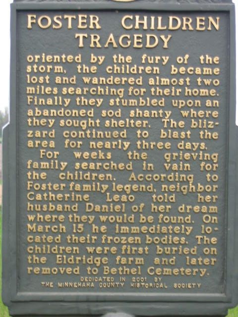
The following appears on pages 260-261 in the “History of Dakota Territory” by George Kingsbury. “On the 7th of January, 1873, a brother and sister of “John Foster,” aged respectively fourteen and twelve years, went a short distance from home and soon afterward a blizzard came up suddenly. The children wandered in the storm to an old sod house that stood out on the prairie and there sought shelter from the driving snow. However, as the house was roofless, it afforded but poor protection against the blizzard, and the children perished, their bodies being buried in the snow. Our subject and the father were absent from home at the time. Weeks passed, and despite continued searching, the bodies of the children were not found, but in March, a neighbor dreamed that the children were in the old house, and on the 16th of that month, their bodies were found there.”

1966: Tropical Cyclone Denise dropped 45 inches of rain on La Reunion Island in the Indian Ocean in 12 hours and 71.80 inches of rain in 48 hours through the 8th. Click HERE for more information from Meteo France. Please note, the webpage will load in French.
1989: Empty foundations are all that remain of four homes on the southwest end of Allendale, Illinois after an F4 tornado ripped through. The tornado was extremely rare due to its strength and the fact that it occurred so far north during the middle of meteorological winter.

2008: A rare, EF3 tornado tracked across southeastern Wisconsin. Experiencing a tornado in Wisconsin in January is extremely rare. In fact, it had only happened once between 1950 and 2007, when an F3 tornado affected parts of Green and Rock Counties on January 24, 1967. That tornado in South Central Wisconsin was part of a much larger outbreak of 30 tornadoes across mostly Iowa, Illinois, and Missouri. Wisconsin ended up with 30 tornadoes in 1967.
Forecast Discussion
- Abnormally Warm Temperatures

Expect temperatures to warm over the next few days as the
southerly flow builds bringing in a warmer air mass. Normal
high temperatures for this time of year are around 31 degrees
with normal lows around 18 degrees. Looking at 925 mb
temperatures, today will be around 5C, Thursday around 7C, and
similar values before the front moves through Friday night
(especially over the southeast portion of the forecast area.
With the high clouds and winds paired with these warm
temperatures aloft we`re looking at highs today in the mid 40s
to low 50s, Thursday in the low to upper 50s (some spots could
hit 60), and Friday in the low to upper 50s along and south of a
Holland to Mount Pleasant line with upper 40s north of that
line. With these abnormally warm temperatures we have the
potential to tie or break records today through Friday for some
areas. Both record high and record warm low temperatures could
be set over the next few days. Check the Climate section below
for the record high temperatures for several areas across
western Michigan.

- Rain chances begin late Thursday Afternoon and continue
  through Friday

High pressure that has dominated the weather pattern will finally be
pushed eastward as a large upper level low moves through the Upper
Midwest. That large upper level low will be forcing an approaching
upper trough along with isentropic ascent which should bring late
afternoon to evening showers across lower Michigan. Fairly warm and
dry air out ahead of the approaching low should keep any
precipitation at bay. A deep band of moisture should move in by
Thursday evening. This will bring rain to southern Lower, especially
regions north of I 96, where the highest QPF is currently. Total QPF
is still below a quarter of an inch. Rain should continue into early
Friday as several waves of mid level moisture traverse the region.
  A slightly stalled boundary  along the Indiana border could allow
for rain to linger into Friday evening.

- Temperatures trend closer toward normal this weekend

As the before mentioned upper level system moves to the east, colder
northerly flow will move into the area Saturday. 850mb temps behind
this front will drop into the -5 to -10C range Saturday night. A
predominately zonal pattern will dominate the pattern through the
weekend. While Max temperatures through the weekend will remain
above normal, they will be much closer and should only be around 5
degrees above normal. There is some model trend of a clipper esque
upper level trough swinging through Sunday evening. That could
bring a chance for snow showers, especially given the cold air
advection and the westerly flow across the lake. However, this is a
low confidence at this point given timing and placement issues. No
impacts expected at this time.
Enjoy the “comfy” weather while it’s here. Hoping the return to reality isn’t too painful.
It will be especially for the people that are wimps!
Hey Mark,
Just to let you know I was able to scan the pix I asked about without removing the dried sticky. They look pretty good. This scanner is amazing. Hubby set it to fix tht color. It takes the orangish out…amazing to see what colors my clothes actually were. Lol.
Nice work!
Here are the record highs and record warmest minimums for today, Thursday and Friday. The record top highs for today at Grand Rapids are 52 in 2004, 51 in 1925, 48 in 1904, 47 in 2019 and 1928, 46 in 1965 and 1900. There will not be a near record warm low for today. At Lansing the record high for today is 54 in 1900, 52 in 2009, 51 in 2019, 50 in 1887 and 1882, 49 in 1878 and 1867. There will be no record warms minimums at Lansing for today
Slim
For tomorrow the top highs at Grand Rapids are 60, in 1925, 59 in 1900, 57 in 1990, 56 in 1937, 53 in 1938. The record warm lows are 49 in 1925, 36 in 1936, 34 in 1938. At Lansing the top record highs are 62 in 1900, 59 in 1869, 56 in 1925, 55 in 1990, 53 in 1937 and 1867. The record warm lows are 39 in 1966, 36 in 2023 and 1898, 35 in 1881.
Slim
And for Friday the top record highs at Grand Rapids are 55 in 1925, 54 in 1990, 53 in 1966, 52 in 1938, 49 in 2001. The top warmest lows are 41 in 1966, 36 in 1999, 34 in 1921. At Lansing the top record highs are 53 in 1990 and 1966, 52 in 1938 and 1925, 51 in 1991 and 50 in 2001. The top record warm lows are 39 in 1966, 36 in 2023 and 1898, 35 in 1881. We shall see how this plays out the next 3 days.
Slim
All long range models show a major cool down and about 6 more weeks of winter weather! WOW! Winter Weather Warning continues! Incredible! Get ready to rock!
Several record high temps and record high minimum temps could be broken over the next couple days! Wow! Blowtorch warning continues!
I have a list of the current record highs and record high minimums for today, Thursday and Friday
Slim
The sunrise this morning was incredible. The most colorful, brilliant sunrise I’ve seen in a long time. I hope my west side friends experienced the same thing.
The upcoming “cool down” will feel cool, relative to the three weeks preceding it. However, the temps appear to remain above average.
It was beautiful this morning. I can mostly see the clouds but they were beautiful!!
The current temperature here in MBY is 25 with mostly cloudy skies. The overnight low was 24 there is once again a good amount of frost here. There have now been 15 days in a row of above average temperatures. The mean at Grand Rapids is 34.1 that is +9.7 at Lansing the mean there is 32.8 that is +9.1 and at Muskegon the mean is 36.8 for a whopping +10.9.
Slim
The official H/L yesterday at Grand Rapids was 41/28 there was no rain/snowfall. For the season GR remains at 34.5” of snowfall that is -20.5” below average as of this date. There was 38% of possible sunshine. For today the average H/L is 32/18 the record high of 52 was set in 2009 and the record low of -15 was set in 1899. The record snowfall of 8.1” fell in 1933 the most snow on the ground was 23” in 2014. Last year the H/L was 45/32 and there was 2” of snow on the ground.
Slim