We have 39° at 5 am. Yesterday’s high in Otsego was 72° with low dew points, which was a perfect day in my mind. Dry conditions are expected through Thursday. Skies will be partly to mostly sunny during the daylight hours. Some smoke may drift overhead from wildfires from Alberta and British Columbia filtering out some of the sunshine. Highs will be in the 60s and 70s, with lows mainly in the 40s, and some 30s and frost possible Wednesday night. Rain chances will increase on Friday.
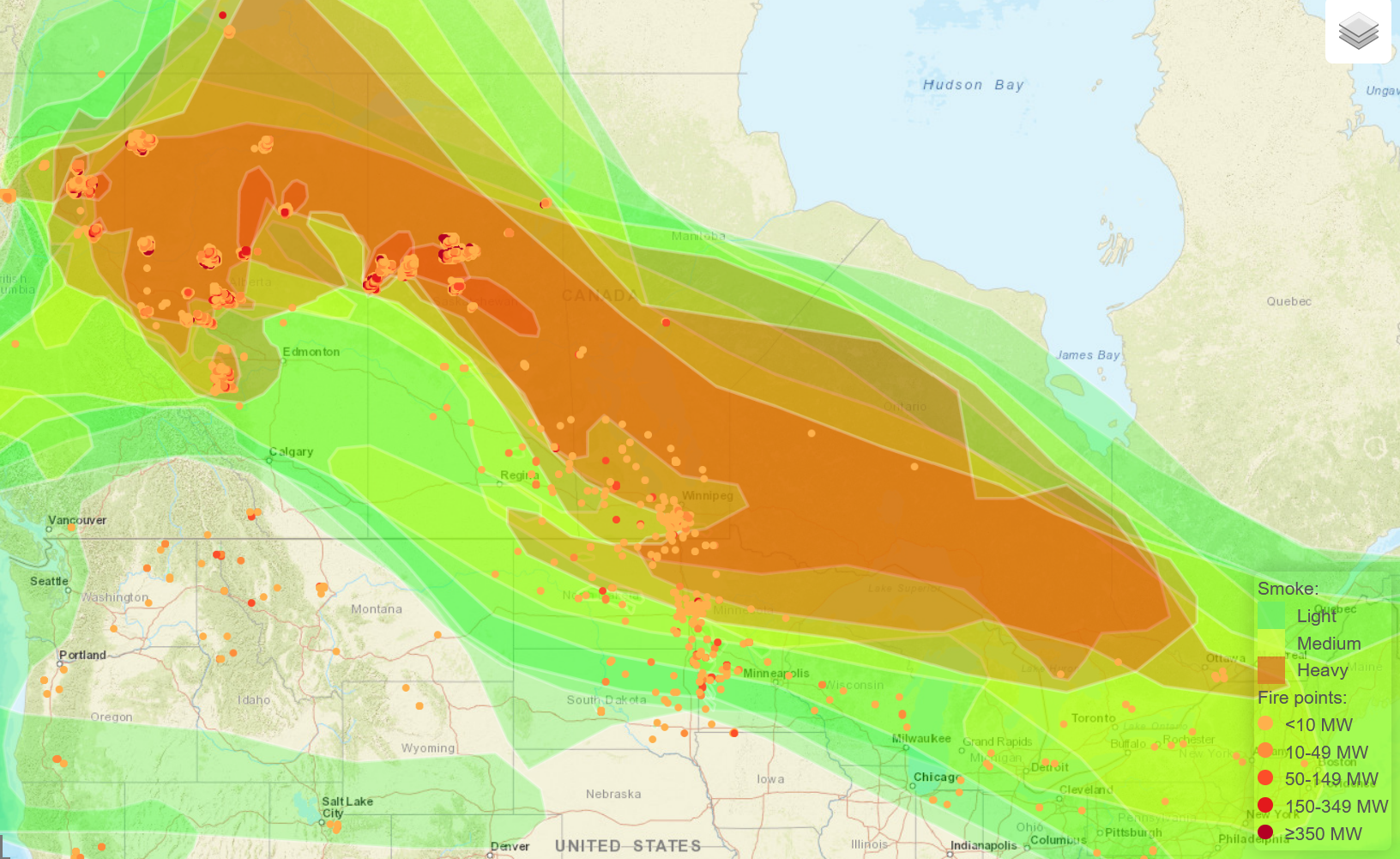
Smoke from Canadian Wildfires
U.S.A and Global Events for May 16th:
1874: The Mill Creek disaster occurred west of North Hampton, MA. Dam slippage resulted in a flash flood that claimed 143 lives and caused a million dollars in property damage. Click HERE for more information from the New England Historical Society.
1983: An unyielding spring storm dumped heavy snow across the Front Range in Colorado. High winds of 20 to 40 mph with gusts to 55 mph produced blizzard conditions at times. The Foothills received 1 to 2 feet of snow with 4 to 12 inches along the Foothills. Blowing snow whipped the snow into drifts several feet deep closing schools and highways. Power outages occurred; with 20 square miles of Denver blacked out. Hundreds of passengers were stranded as only half of the runways were open at Stapleton International Airport. The high temperature at Denver the next day of just 40° set a record low maximum. Much of the snow melted on the 18th as temperatures rebounded into the middle and upper 50s causing widespread street flooding.
1989: Thunderstorms developing ahead of a cold front produced severe weather in the south-central U.S. Thunderstorms spawned twenty tornadoes, and there were 180 reports of large hail and damaging winds. A tornado in Cleburne, Texas caused thirty million dollars in damage. A violent F-4 tornado touched down near Brackettville, Texas and a strong F-3 tornado killed one person and injured 28 others at Jarrell, Texas.
Grand Rapids Forecast
5 16 grrForecast Discussion
-- Dry Cold Front Today --

A large upper level low situated over north eastern Canada will
dictate the weather pattern today. This upper level low will move
southward driving a cold front across Michigan this afternoon and
evening. The models are in fair agreement on the placement and
the timing of this systems features so expect frontal passage to
be late this afternoon. There is decent dry air associated with
this so don`t expect any significant precipitation though a few
sprinkles along the US 127 corridor north of Lansing is possible.
The tight pressure gradient will however allow for gusty winds
this afternoon through at least the early evening hours.

-- Cold Overnight Lows through Thursday --

That cold northerly flow will continue through Wednesday. So cold
air advection is expected tonight into Wednesday morning. Couple
that with clearing skies and there will be the potential for frost
formation, especially along the US 10 corridor. The limiting
factor however is that a strong pressure gradient will persist due
to the strong low pressure system. That persistent wind should stifle
frost formation. So while patchy frost remains possible, the winds
should hold off on any frost/freeze headlines for now.

Mild  weather will continue Wednesday with another cold night in
store Thursday morning. However, the difference will be a
building high pressure system that could allow for weak winds and
another chance for frost.

-- Rain chances Late this week --

A building high will briefly reside over the area Thursday a
deepening upper level low approaches through the upper midwest.
There remains very little instability with this system so thunder
is not expected. There is however, a decent ribbon of moisture
associated with this system which should allow for a strong
frontal band of precipitation. Timing issue remains with the EC
slower as it deepens and closes the low as it enters the Great
Lakes region. However, ensembles seems to close in on
precipitation mainly Friday so the highest chance will be Friday
afternoon with rain potentially lingering into the evening. The
system should exit by Saturday with dry and mild weather in its
wake.
Get ready – the cool pattern continues. Low temps the next 2 nights in the upper 30’s, now that is some serious mid May cold! Wow, just wow, WOW!
This wildfire smoke is very thick. Not much sunlight shining through.
It reached 79 here. If not for the smoke, I think we would have had our 7th 80-degree day this spring. Speaking of which, our local TV met showed 80s for five days in next week’s forecast (Wed – Sun).
I like the sounds of the 80s in the forecast!
No 80’s are in sight! Cool nights and highs in the 60’s and low to mid 70’s!
You must be blind…
https://weather.com/weather/tenday/l/b523690bfd952b86fef3627c919dd9855281a8da16b83c10bdd381c64ae12cbc
Also we have wildfire smoke over the area right now with a wind from the NW. I think the wind direction will be changing to the east tonight and hopefully clear it out
It’s very thick. I feel like this is some of the thickest I’ve ever seen.
Looking a bit cool the rest of this week (especially at night). Hopefully we are able to avoid any frost… tomorrow night looks close to frost advisory criteria
8-14 day from the CPC is starting to look like a blowtorch!
It’s amazing how quiet the severe weather season has been in Minnesota, Wisconsin, and Michigan so far this year. As a matter of fact Minnesota has seen the least amount of all the midwestern states coming off last year being at the top. One has to wonder if this will be yet another below average severe weather year for Michigan or will the pattern flip more active into June and July? We shall see.
My sprinklers are working overtime in mid May. When was the last time that happened?
We are locked into a sunny and dry pattern already.
The next few days we will see below normal temps and then basically near normal temps after that, so the overall cool pattern still rocks!
It is absolutely delightful out. Cool mornings, warm afternoons, and lots of sun (only two cloudy days here this month). We could use some rain, though. My grass is beginning to dry out a bit.
It’s been a warm May so far and the new CPC shows nothing but warmth! And with all the sunshine and lack of rain, I’m beginning to think it’s 2022 all over again.
Yesterday was yet another below normal temp day and get used to it as the cool pattern is rocking!
Cool crisp May mornings are the best I must say most od Mays weather is the best we are transforming into Summer nice cool and slow with no heat waves in sight baby lets keep the coolness going into September yeahhhh great balls of fire INDY
Sounds good to me and no real heat is in sight! I love the cool pattern!
The next 5 days look to be a few degrees either side of average. There is a chance of frost away from the metro areas and to the north. And later towards the end of the week a chance of showers. At the current time it is 41 here in MBY a good 5° colder there than at GRR.
Slim
After a cold start yesterday was a very nice mid May day with a H/L of 73/38. There was no rain fall and 99% of possible sunshine. There were 9 HDDs and 0 CDDs The overnight low here in MBY for today was 40. For today the average H/L is 70/49 the record high of 89 was set in 1962 and 1977 the record low of 29 was set in 1997 the record rain fall of 1.97” fell in 1974.
Slim